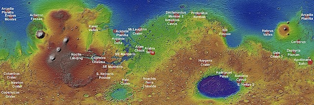
 We [the US Geological Survey] have created 39 regional semi-controlled CTX mosaics at 5m/pixel for the 2015 proposed Mars Human Exploration zones. They are individually available for download in GeoTiff format from the “Online Linkage” tag below. Cosmetically, mosaics will have hard edges between images due to seasonal, time, and calibration differences. [Note: the image files average 2 GB each in size.]
These regions were originally proposed during the Mars Human Exploration Zone meeting in October 2015. http://www.hou.usra.edu/meetings/explorationzone2015/.
The Context Camera (CTX) on the Mars Reconnaissance Orbiter (MRO) is a Facility Instrument (i.e., government-furnished equipment operated by a science team not responsible for design and fabrication) designed, built, and operated by Malin Space Science Systems and the MRO Mars Color Imager team (MARCI). CTX will (1) provide context images for data acquired by other MRO instruments, (2) observe features of interest to NASA’s Mars Exploration Program (e.g., candidate landing sites), and (3) conduct a scientific investigation, led by the MARCI team, of geologic, geomorphic, and meteorological processes on Mars. [More at links]


