THEMIS: False-color dunes in Proctor Crater

False-color dunes in Proctor Crater (THEMIS_IOTD_20180830)
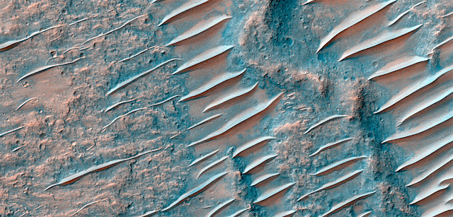
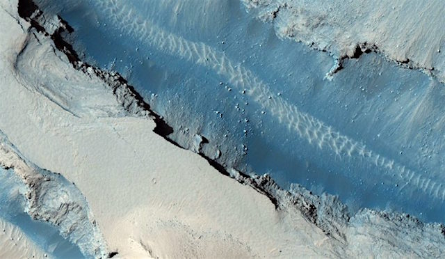
THEMIS Image of the Day, August 30, 2018. Today’s false-color image shows the floor of Proctor Crater, including the large dune field. Basaltic sands are typically blue in false-color images. Proctor Crater is located in Noachis Terra.

The THEMIS VIS camera contains 5 filters. The data from different filters can be combined in multiple ways to create a false color image. These false color images may reveal subtle variations of the surface not easily identified in a single band image.

See more THEMIS Images of the Day by geological subject.

Posted in Reports | Tagged , , , , , , , , , | Comments Off

HiRISE: Extensive layer exposures

tumblr_pe6utjvME81rlz4gso2_1280Extensive layer exposures. Be sure to read the caption of the stereo partner for this observation for some more information about the layers.

Beautiful Mars series. [More at links]

Posted in Reports | Tagged , , , , , , , , , | Comments Off

MARCI weather report, August 20-26, 2018

MARCI-August-22-2018Afternoon skies became less dusty as dust continued to settle out of the atmosphere this past week. In the middle of the week, local dust storm activity returned to Noachis Terra. During that time, a dust storm pushed southward over Xanthe Terra — later lofting a dust cloud over western Valles Marineris. Small transient storms were spotted along the seasonal south polar ice cap edge throughout the week. For most afternoons… [More at link, including video]

Posted in Reports | Tagged , , , , , , , , , , , , , , , | Comments Off

Searching for signs of marsquakes

part-of-the-cerberus-fossae-fault-hirise-mars-reconnaissance-orbiter-800x600Rovers and landers have been studying Mars’s surface for decades, but the inner workings of the Red Planet are still mysterious. No one yet knows for sure what sort of seismic activity rocks the Red Planet. That’s not for lack of trying: As far back as the 1970s, NASA attempted to detect “marsquakes” in much the same way that tremors on Earth are detected—with seismometers aboard the twin Viking landers. But the instruments aboard the landers either failed or collected compromised data.

Yet, despite the lack of confirmed quakes so far, researchers suspect—based on fault maps of the planet—that Mars likely has more tremors than the Moon but fewer than Earth. This suspicion may be confirmed in November 2018 with the first seismic-focused mission to Mars, the Interior Exploration using Seismic Investigations, Geodesy and Heat Transport (InSight) lander.

[Reporting in the Journal of Geophysical Research, Peter Grindrod and colleagues] took a different approach: The team studied images of Mars’s surface over nearly a decade to look for changes that might have been caused by marsquakes. The researchers used images of Mars’s surface from the High Resolution Imaging Science Experiment (HiRISE) and applied Co-registration of Optically Sensed Images and Correlation (COSI-Corr)—software that has been validated to track terrestrial glaciers, landslides, and quakes on Earth, as well as dune movement on Mars itself—to hunt for signs of displacement near fault zones.

The researchers focused on the Cerberus Fossae fault system, the youngest fault system on the Red Planet and thus the most likely to still be active. They used the average coregistration performance of each study image to determine that this method should be able to detect fault slip rates of 0.1–10 millimeters a year…. [More at links]

Posted in Reports | Tagged , , , , | Comments Off

Weather update from Gale Crater

Posted in Reports | Tagged , , , , , , , , | Comments Off

THEMIS: Pits and channels on Ascraeus Mons

Pits and channels on Ascraeus Mons (THEMIS_IOTD_20180829)THEMIS Image of the Day, August 28, 2018. This VIS image shows a portion of the northern flank of Ascreaus Mons. Multiple linear depressions cut across the surface lava flows, having formed after the surface in this region.

The chains of oval depressions typically form when a subsurface void is filled by collapse of the “roof” above it.

See more THEMIS Images of the Day by geological subject.

Posted in Reports | Tagged , , , , , , , , , , , , | Comments Off

Curiosity update: What a dump

2154MH0004650010802748C00_DXXX-br2Sol 2155 August 29, 2018, update by MSL scientist Ryan Anderson: Our second attempt at a dump was successful! The plan for Sol 2155 starts with a whole slew of Mastcam images to check out various components of the arm turret, plus a MAHLI observation of the dump pile. After that, Navcam will look toward the crater rim to measure the amount of dust in the air, and ChemCam will analyze the targets “Ben Macdui” and “Tarskavaig,” both of which appear to be interesting features where the bedrock chemistry and mineralogy may have been altered. Mastcam will take pictures… [More at link]

Posted in Reports | Tagged , , , , , , , , , , , , , | Comments Off

Opportunity: No word yet as skies begin to clear

NASA Mars Exploration Rover Status Report, August 23, 2018: No signal from Opportunity has been heard. The dust storm on Mars continues to decay.

There has been no new storm activity within ~1,864 miles (3,000 kilometers) of the rover site. The atmospheric opacity (tau) over the rover is decreasing. As reported previously, it is expected that Opportunity has experienced a low-power fault, and then perhaps, a mission clock fault. (…)

The science team is also sending a command three times a week to elicit a beep if the rover happens to be awake… [More at link]

Posted in Reports | Tagged , , , , , , , , , , , | Comments Off

HiRISE: The land beaten by time

tumblr_pe6uetGwdA1rlz4gso2_1280The land beaten by time. This region is called Hydraotes Chaos and is about 418 km in diameter.

Beautiful Mars series. [More at links]

Posted in Reports | Tagged , , , , , , , , | Comments Off

Curiosity: Stoer drill and dump sites

2154-mastcam2154MH0004650010802746C00_DXXXSol 2154, August 28, 2018. With the rover parked at the Stoer drill site, the above Mastcam composite shows the drill site itself (right arrow) and the tailings dump site (left arrow).

2154MH0004650010802748C00_DXXXAt right are MAHLI images of the two places. (Click any image to enlarge it.)

Sol 2154 raw images (from all cameras).

Posted in Reports | Tagged , , , , , , , , , | Comments Off