HiRISE: Inverted channels

tumblr_p8s5z96tY41rlz4gso2_1280Inverted channels at the boundary of highlands and intercrater plains. This image targets inverted channels located at the boundary between Noachian highlands and Noachian intercrater plains bedrock. These channels are 200 to 500 meters wide, implying substantial fluvial activity. High-resolution imagery of these channels will aid in characterizing the amount of fluvial activity responsible for their formation. This location is also one of the few places where evidence of sedimentary processes operating to form intercrater plains has been clearly preserved.

Beautiful Mars series. [More at links]

Posted in Reports | Tagged , , , , , , , , , | Comments Off

How active is Mars seismically? A prediction

grl57054-fig-0003-mThe Interior Exploration using Seismic Investigations, Geodesy, and Heat Transport (InSight) mission arrives on Mars in November 2018. In anticipation of its arrival, a group of researchers led by Dr. Ana-Catalina Plesa have focused on the seismic experiments, which aim to probe the distribution of seismicity across Mars. They have conducted a series of numerical models based on convective stresses associated with cooling and planetary contraction. Their estimates [published in Geophysical Research Letters] place the total seismicity on Mars somewhere between that of the Earth and the Moon…

[From the Discussion section of the paper:] The upcoming InSight measurements will help determine the amount and distribution of Martian seismicity by monitoring the seismic activity for one Martian year. Although the mission provides only one seismic station, the presence of depth phases and the relative amplitude of surface waves with respect to body waves will provide constraints on the depth distribution of seismic sources.

On Earth, essentially all seismicity below the Moho is connected to plate boundaries and subduction of cold lithosphere. Mars, on the other hand, is a one‐plate planet and so far deep seismicity was not expected to exist. This view, however, is challenged by the HC models presented here, which suggest that the seismogenic volume could extend to depths of about 400 km, if the base of the seismogenic layer is marked by the 1073 K isotherm… [More at links]

Posted in Reports | Tagged , , , , , , , | Comments Off

HiRISE: North polar layered deposits

tumblr_p928baJg791rlz4gso1_1280North polar layered deposits. Beautiful Mars series. [More at links]

Posted in Reports | Tagged , , , , , , , , | Comments Off

THEMIS: Cerberus Fossae, source of floods

Cerberus Fossae source of floods (THEMIS_IOTD_20180522)THEMIS Image of the Day, May 22, 2018. Today’s VIS image shows a section of Cerberus Fossae. Located southeast of the Elysium Planitia volcanic complex, the linear graben was created by tectonic forces related to the volcanic activity.

The fossa cuts across features such as hills, indicating the relative youth of the tectonic activity. This fossa is also the source of several channels, some of which are visible on the lower half of the image.

More THEMIS Images of the Day by geological topic.

Posted in Reports | Tagged , , , , , , , , , , , , | Comments Off

Opportunity: Looking at La Joya

5091-miSol 5091, May 21, 2018. Mission scientists commanded the rover to use its Microscopic Imager to shoot a 2×3 composite image of part of the rock dubbed La Joya. In the plans is an additional survey of a different part of the rock. Click the image to enlarge it.

Opportunity raw images, its latest mission status, location map, and atmospheric opacity, known as tau.

Posted in Reports | Tagged , , , , , , , , | Comments Off

Curiosity update: Poised

2054ML0108870040800875E01_DXXX-br2
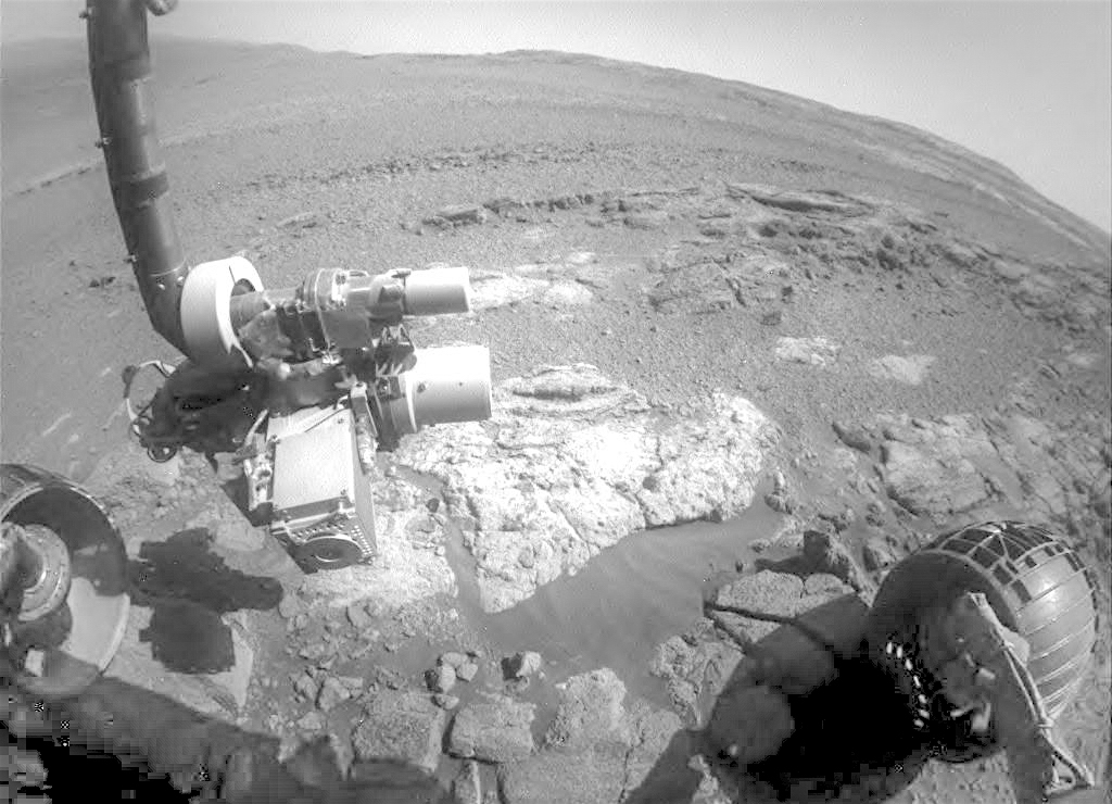
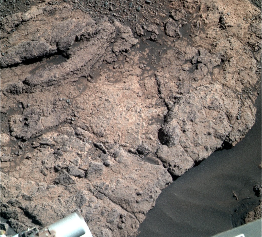
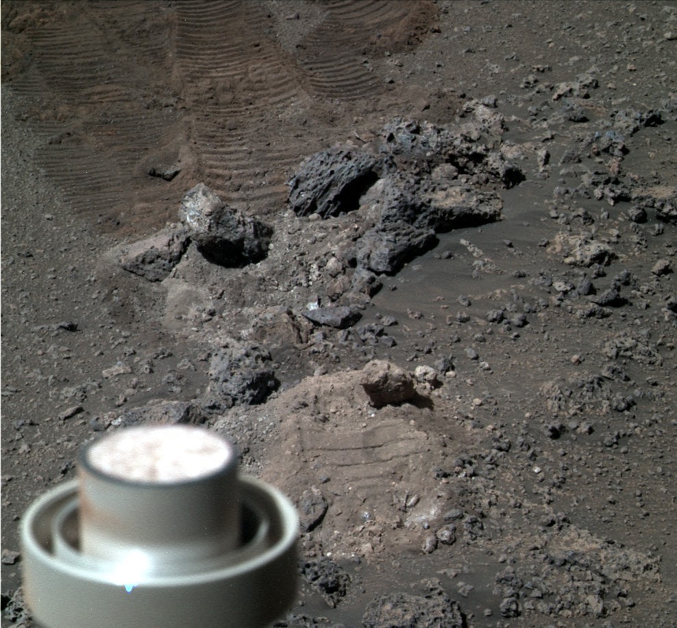
Sols 2056-58, May 21, 2018, update by MSL scientist Michelle Minitti: This weekend, Curiosity will attempt to sink the drill into the complexly-layered “Duluth” block. Before that, she will gather more data from the “Blunts Point” member rocks in front of and around us.

The Duluth target, neatly cleared of dust by the DRT in yesterday’s plan, will be observed by ChemCam’s passive mode and Mastcam’s multispectral mode to gauge what iron mineralogy was hiding beneath the target’s thin veneer of dust. ChemCam will shoot three targets to learn more about the chemistry of the layers within the Duluth block and similar blocks around it. Within the Duluth block, ChemCam will target “Chisholm,” the delicate layer curling up above the top of the Duluth block, and “Aitkin,” another layer jutting out from the side of the block.

The “Buhl” target sits off to the rover’s right and represents another example of the Blunts Point member for ChemCam to sample. Mastcam will then image two large blocks dubbed “Kabetogama” to learn more about the intricate layering of the Blunts Point member. Before drilling, Curiosity will also give the sky some attention. Images and movies acquired in the early morning will measure dust and look for clouds, while images and movies at mid-day will measure dust and look for dust devils. REMS and RAD will gather data regularly as the weekend progresses…. [More at link]
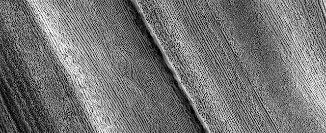
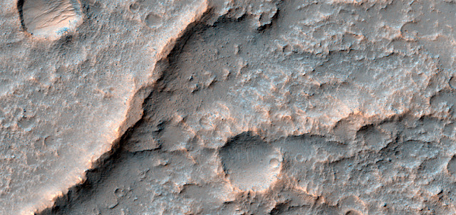
Posted in Reports | Tagged , , , , , , , , , , , , | Comments Off

THEMIS: Lava flows chopped by graben in Olympica Fossae

Grooves through lava flows (THEMIS_IOTD_20180521)THEMIS Image of the Day, May 21, 2018. The linear channel in the bottom half of this VIS image is part of Olympica Fossae. Olympica Fossae is a complex channel form located on the Tharsis plains between Alba Mons and Olympus Mons.

It was most likely created by volcanic flows, but was probably also affected by the formation of graben in the region. Graben are formed by the down-drop of material between paired faults. The collapse of the Alba Mons volcano resulted in a huge region of graben.

More THEMIS Images of the Day by geological topic.

Posted in Reports | Tagged , , , , , , , , , , , | Comments Off

HiRISE: Twin craters in Meridiani Planum

ESP_050849_1700This image shows two small impact craters located in Meridiani Planum. This is an example of the geologic principle of superposition: figuring out what happened first by looking at how features interact with each other. We can see that one of the craters must have hit the surface after the other was already there, but which came first?

We can see that the ejecta blankets look rougher on the right side of the image than they do on the left. This could mean that the right side ejecta is newer, and hasn’t been exposed to the wind as much as the left side has… [More at link]

Posted in Reports | Tagged , , , , , , , , | Comments Off

Opportunity: La Joya and disturbed soil

1F579785397EFFD2FCP1215R0M11P579784437ESFD2FCP2557L5M1_L4L5L5L5L6Sol 5087, May 16, 2018. Opportunity is parked at La Salinera, an exposed outcrop on the edge of Persevereance Valley. Scientists are using the Pancam to take multi-colored images of targets nearby, producing false-color composite images that reveal differences in surface materials.

1P579783320ESFD2FCP2558L5M1_L4L5L5L5L6Above is the front Hazcam’s view of the target rock La Joya, and at right are Pancam false-color (Holger Isenberg) reconstructions of La Joya and a patch of wheel-disturbed soil. Click any image to enlarge it.

Opportunity raw images, its latest mission status, location map, and atmospheric opacity, known as tau.

Posted in Reports | Tagged , , , , , , , , , | Comments Off

Curiosity update: Drill site perspectives from a Duluth native

FLB_579844232EDR_F0701752FHAZ00337M_-br2Sol 2055, May 18, 2018, update by MSL scientist Roger Wiens: I was excited to learn earlier this week that my native city was chosen as the name of the latest drill site on Mars! The name was selected by geologists on the mission to recognize the Duluth Complex, one of the largest intrusions of gabbro on Earth, along the north shore of Lake Superior. But, as the team likes one-word names, we are just calling the drill site “Duluth.” The name was almost changed yesterday when it was realized that “Duluth” was already used for a ChemCam target on Sol 292. Normally we don’t use names more than once, but the team decided an exception was warranted.

Duluth, my birth city, was at one time the busiest port in the United States in terms of gross tonnage, surpassing even New York for a while. It is still considered the largest freshwater port in the world even though it is one of the farthest inland, at 3770 km from the Atlantic Ocean. Duluth has one of the coolest climates in the US due to its proximity to the world’s largest and one of the deepest freshwater lakes. The drill target “Duluth” on Mars was also once near the shore of a large freshwater lake. Its climate is also relatively cool, so the name is apropos…. [More at link]

Posted in Reports | Tagged , , , , , , , , , , | Comments Off