HiRISE: Pits in the south polar layered deposits

tumblr_oyngfgJ4Sw1rlz4gso1_1280Pits in the south polar layered deposits. Beautiful Mars series.

Posted in Reports | Tagged , , , , , , , , , , | Comments Off

Curiosity: Rolling ahead

1864-navcamSol 1864, November 3, 2017. After a 25-meter (82-foot) drive, Curiosity halted and looked ahead with its Navcam. The rover is near a geological contact with a darker, thinly stratified layer which overlies the rock it has been driving on. Click image to enlarge it.

Sol 1864 raw images (from all cameras), and Curiosity’s latest location.

Posted in Reports | Tagged , , , , , , , , | Comments Off

THEMIS: Collapsed lava tubes on Pavonis Mons

Collapsed lava tubes on Pavonis Mons (THEMIS_IOTD_20171103)
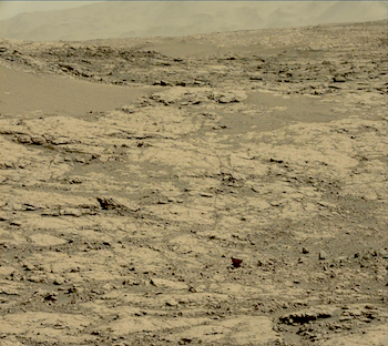
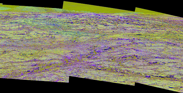
THEMIS Image of the Day, November 3, 2017. This image shows part of the southeastern flank of Pavonis Mons. Surface lava flows run down hill from the top left of the image to the bottom right. Perpendicular to that trend are several linear features. These are faults that encircle the volcano and also run along the linear trend through the three Tharsis volcanoes.

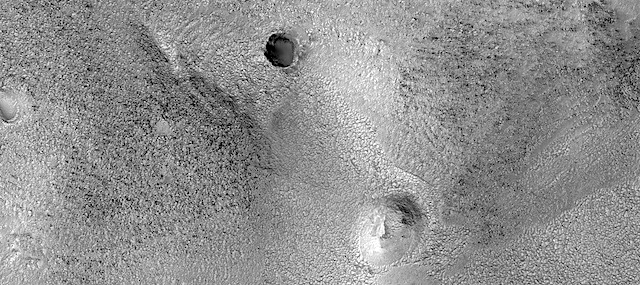
This image illustrates how subsurface lava tubes collapse into the free space of the empty tube. Just to the top of the deepest depression are a series of circular pits. The pits coalesce into a linear feature near the left side of the deepest depression.

The mode of formation of a lava tube starts with a surface lava flow. The sides and top of the flow cool faster than the center, eventually forming a solid, non-flowing cover of the still flowing lava. The surface flow may have followed the deeper fault block graben (a lower surface than the surroundings). Once the flow stops there remains the empty space lower than the surroundings, and collapse of the top of the tube starts in small pits which coalesce in the linear features.

Pavonis Mons is one of the three aligned Tharsis Volcanoes. The four Tharsis volcanoes are Ascreaus Mons, Pavonis Mons, Arsia Mons, and Olympus Mars. All four are shield type volcanoes. Shield volcanoes are formed by lava flows originating near or at the summit, building up layers upon layers of lava. The Hawaiian islands on Earth are shield volcanoes. The three aligned volcanoes are located along a topographic rise in the Tharsis region. Along this trend there are increased tectonic features and additional lava flows.

Pavonis Mons is the smallest of the four volcanoes, rising 14 km above the mean Mars surface level with a width of 375 km. It has a complex summit caldera, with the smallest caldera deeper than the larger caldera. Like most shield volcanoes the surface has a low profile. In the case of Pavonis Mons the average slope is only 4 degrees.

NASA’s Mars Odyssey spacecraft has spent over 15 years in orbit around Mars, circling the planet more than 69,000 times. It holds the record for longest working spacecraft at Mars. THEMIS, the IR/VIS camera system, has collected data for the entire mission and provides images covering all seasons and lighting conditions.

Over the years many features of interest have received repeated imaging, building up a suite of images covering the entire feature. From the deepest chasma to the tallest volcano, individual dunes inside craters and dune fields that encircle the north pole, channels carved by water and lava, and a variety of other feature, THEMIS has imaged them all.

For the next several months the Image of the Day will focus on the Tharsis volcanoes, the various chasmata of Valles Marineris, and the major dunes fields. We hope you enjoy these images!

More THEMIS Images of the Day by geological topic.

Posted in Reports | Tagged , , , , , , , , , , , , | Comments Off

Curiosity update: Planning to drive again

1850ML0096800030703100E01_DXXX-br2Sol 1863, November 1, 2017, update by MSL scientist Roger Wiens: Curiosity will finally be back on the move. The rover made an unexpected stop of nearly two weeks in the current location due to several things ranging from failed uplinks to insufficient arm heating and a camera glitch. It reminds us that everything must work just right to successfully operate a robot on Mars. In addition to thorough remote and contact analyses of this stop, Curiosity had several other notable accomplishments, including placing the drill down on the ground for a test, and dropping off a sample of “Ogunquit Beach” dune soil to SAM for evolved gas analysis.

The rover team is planning two sols of operation. Curiosity has a ~25 meter drive planned for Thursday, hoping to stop between the two sandy areas shown to the left and right in the image. Before the drive it is doing ChemCam observations on “Gravelotte,” “Sibasa,” and “Brooklands.” APXS will have an… [More at link]

Posted in Reports | Tagged , , , , , , , , , , , , , | Comments Off

MARCI weather report, October 23-29, 2017

MARCI-October-25-2017This past week dust-lifting near the edge of the perennial north polar ice cap transported dust to the plains of Arcadia and Acidalia. Meanwhile, an expanse of water-ice clouds, known as the aphelion cloud-belt continued to dominate the skies of the low latitudes. In the southern highlands, a few small transient dust storms were observed just south of Solis Planum. Ground frost and condensate water-ice clouds became more abundant…  [More at link, including video]

Posted in Reports | Tagged , , , , , , , , , , , , , | Comments Off

HiRISE: Light and dark in Ultimi Scopuli

tumblr_oyngdmHHV21rlz4gso1_1280Light and dark in Ultimi Scopuli. Beautiful Mars series.

Posted in Reports | Tagged , , , , , , , , | Comments Off

THEMIS: Summit caldera edge, Pavonis Mons

Summit caldera edge on Pavonis Mons (THEMIS_IOTD_20171102)THEMIS Image of the Day, November 2, 2017. This image shows part of the two summit calderas of Pavonis Mons. The surface in the majority of the image is the floor of the larger caldera. The smaller caldera occupies the bottom of the image. In both calderas the floor is predominately flat. The final summit flow would have pooled in the caldera and cooled forming the flat floor.

Pavonis Mons is one of the three aligned Tharsis Volcanoes. The four Tharsis volcanoes are Ascreaus Mons, Pavonis Mons, Arsia Mons, and Olympus Mars. All four are shield type volcanoes. Shield volcanoes are formed by lava flows originating near or at the summit, building up layers upon layers of lava. The Hawaiian islands on Earth are shield volcanoes. The three aligned volcanoes are located along a topographic rise in the Tharsis region. Along this trend there are increased tectonic features and additional lava flows.

Pavonis Mons is the smallest of the four volcanoes, rising 14 km above the mean Mars surface level with a width of 375 km. It has a complex summit caldera, with the smallest caldera deeper than the larger caldera. Like most shield volcanoes the surface has a low profile. In the case of Pavonis Mons the average slope is only 4 degrees.

NASA’s Mars Odyssey spacecraft has spent over 15 years in orbit around Mars, circling the planet more than 69,000 times. It holds the record for longest working spacecraft at Mars. THEMIS, the IR/VIS camera system, has collected data for the entire mission and provides images covering all seasons and lighting conditions.

Over the years many features of interest have received repeated imaging, building up a suite of images covering the entire feature. From the deepest chasma to the tallest volcano, individual dunes inside craters and dune fields that encircle the north pole, channels carved by water and lava, and a variety of other feature, THEMIS has imaged them all.

For the next several months the Image of the Day will focus on the Tharsis volcanoes, the various chasmata of Valles Marineris, and the major dunes fields. We hope you enjoy these images!

More THEMIS Images of the Day by geological topic.

Posted in Reports | Tagged , , , , , , , , , , | Comments Off

CRISM: Hydrated minerals in Chryse Planitia

Chryse PlanitiaThe Chryse Planitia is a smooth circular plain that has a diameter of 1600 km, and has a depth of 2.5 km below its average surface altitude, making it one of Mars’s lowest regions. Chryse Planitia was a landing site for the U.S Viking 1 (landed July 20, 1976), and the Mars Pathfinder (landed July 4, 1997). It is theorized that Chryse was once the site of a large body of water; many of the large outflow channels and ancient river valleys in the southern highlands, such as Mawrth Vallis, end at Chryse. These valley systems are thought to be evidence of past water erosion, suggesting that the water they carried flowed into Chryse.

This image is of the boundary of Chryse Planita, just north of Oyama crater and to the west of Mawrth Vallis. Iron-magnesium phyllosilicates (black), aluminum phyllosilicates (red/yellow), kaolinite (white) and alunite (cyan), a type of sulfate, are all detected. Phyllosilicates are clay and clay-like minerals formed during interaction between rock and liquid water. On Mars, iron-magnesium phyllosilicate is formed by reaction of igneous basaltic rocks with water, and is common in the southern highlands. The formation of aluminum phyllosilicates, however, implies… [More at link]

Posted in Reports | Tagged , , , , , , , , , , , , , | Comments Off

Vera Rubin Ridge brings out rover’s color talents

pia22065-special-filter[Editor’s note: See also here.]

Color-discerning capabilities that NASA’s Curiosity rover has been using on Mars since 2012 are proving particularly helpful on a mountainside ridge the rover is now climbing.

These capabilities go beyond the thousands of full-color images Curiosity takes every year: The rover can look at Mars with special filters helpful for identifying some minerals, and also with a spectrometer that sorts light into thousands of wavelengths, extending beyond visible-light colors into infrared and ultraviolet. These observations aid decisions about where to drive and investigations of chosen targets.

One of these methods for discerning targets’ colors uses the Mast Camera (Mastcam); the other uses the Chemistry and Camera instrument (ChemCam).

Each of the Mastcam’s two eyes — one telephoto and one wider angle — has several science filters that can be changed from one image to the next to assess how brightly a rock reflects light of specific colors. By design, some of the filters are for diagnostic wavelengths that certain minerals absorb, rather than reflect. Hematite, one iron-oxide mineral detectable with Mastcam’s science filters, is a mineral of prime interest as the rover examines “Vera Rubin Ridge.”

“We’re in an area where this capability of Curiosity has a chance to shine,” said Abigail Fraeman of NASA’s Jet Propulsion Laboratory, Pasadena, California, who leads planning for the mission’s investigation of Vera Rubin Ridge. [More at links]

Posted in Reports | Tagged , , , , , , , , , , , , | Comments Off

HiRISE: Exposed cross section of a flow

tumblr_oyng96tQcK1rlz4gso2_1280Exposed cross section of a flow in Phlegra Montes: Material may have moved down the valley, then been truncated. If this is indeed what happened, this could be important because it shows the inside of a flow.

Beautiful Mars series.

Posted in Reports | Tagged , , , , , , , , , | Comments Off