Valley networks point to much wetter past

press2vertical
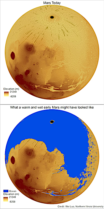
A new study led by Northern Illinois University geography professor Wei Luo calculates the amount of water needed to carve the ancient network of valleys on Mars and concludes the Red Planet’s surface was once much more watery than previously thought.

The study bolsters the idea that Mars once had a warmer climate and active hydrologic cycle, with water evaporating from an ancient ocean, returning to the surface as rainfall and eroding the planet’s extensive network of valleys.

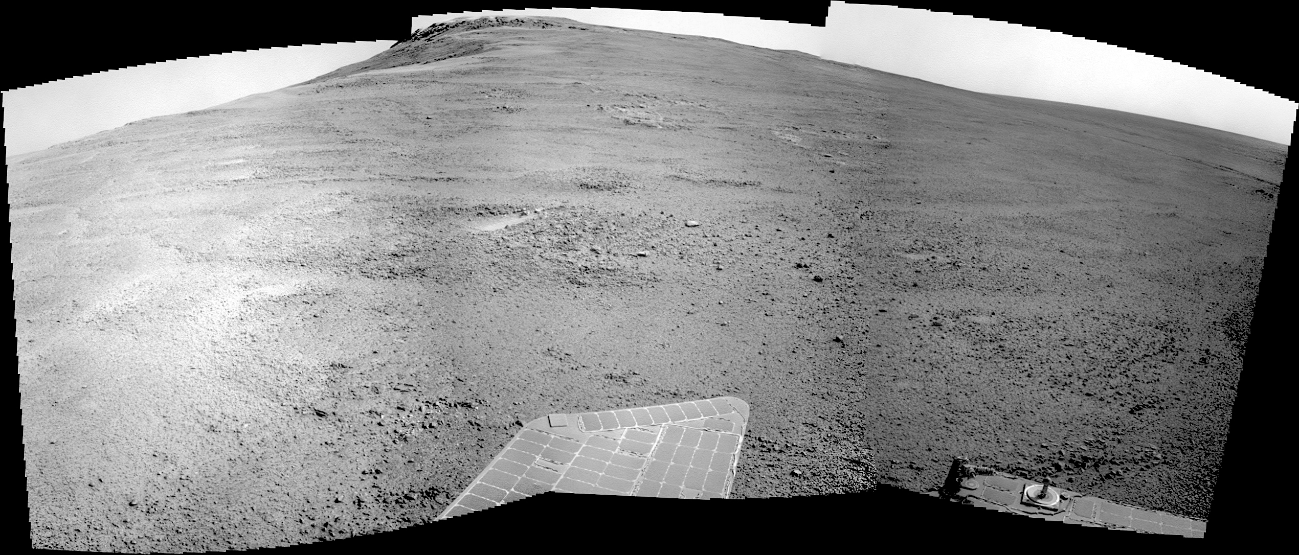
Satellites orbiting Mars and rovers on its surface have provided scientists with convincing evidence that water helped shape the planet’s landscape billions of years ago. But questions have lingered over how much water actually flowed on the planet, and the ocean hypothesis has been hotly debated.

In the new study, published June 5, in the online journal Nature Communications, Luo and colleagues used an innovative algorithm to more precisely calculate the volume of cavity space within Mars valleys and the amount of water that would have been needed to create those cavities through erosion over time. The majority of the valley networks are more than 3 billion years old.

“Our most conservative estimates of the global volume of the Martian valley networks and the cumulative amount of water needed to carve those valleys are at least 10 times greater than most previous estimates,” Luo said. [More at links]

Posted in Reports | Tagged , , , | Comments Off

THEMIS: Afternoon shadows near south pole

South polar afternoon shadows (THEMIS_IOTD_20170605)THEMIS Image of the Day, June 5, 2017. Today’s VIS image is of an unnamed crater near the south pole. This image was taken in the late afternoon, and the low sun angle created shadows cast by the crater rim and by a peak within the crater.

More THEMIS Images of the Day by geological topic.

Posted in Reports | Tagged , , , , , , , , | Comments Off

HiRISE: Gullies and craters and dunes, oh my!

ESP_050111_1305This unnamed, approximately 30-kilometer diameter crater, formed in the Southern highlands of Mars. Our image shows regions of geologic diversity within, making this an interesting spot for scientists to study how different Martian processes interact with each other.

Gullies, or channels formed by fluids such as water or lava, cut into the rim and sides of this crater. The presence of gullies can reveal clues about the ancient history of Mars, such as the amount of flowing fluid needed to form them and roughly how long ago that happened. This crater may also host features actively changing on the surface of Mars known as “recurring slope lineae” (RSL). Manifesting as dark streaks on steep slopes such as the walls of… [More at link]

Posted in Reports | Tagged , , , , , , , , , , | Comments Off

Curiosity update: Let’s try that again

1712ML0089330040701369E01_DXXX-br2Sol 1714, June 1, 2017, update by MSL scientist Lauren Edgar: Unfortunately the Sol 1713 activities were not uplinked due to an issue at the DSN station, so today’s plan is focused on recovering the activities that were planned yesterday.  The good news is that we’ll be in the same location for the start of the weekend plan, so we’ll be able to add some additional contact science targets at this interesting site.

I was the SOWG Chair today, and it was a pretty straightforward planning day since it was mostly a repeat of yesterday!  The plan kicks off with Mastcam mosaics of “The Whitecap,” “Trap Rock,” and “Pond Island” to document some nearby sedimentary structures.  Then ChemCam will target “Heron Island” and “McNeil Point” to investigate variations in chemistry within the darker gray rocks in this area… [More at link]

Posted in Reports | Tagged , , , , , , , , , , , , , , , , | Comments Off

HiRISE: Slide on down

tumblr_oq3rgxT9CJ1rlz4gso1_1280Slide on down. Beautiful Mars series.

Posted in Reports | Tagged , , , , , , , , , , | Comments Off

Curiosity: Fore and aft Hazcam views

FRB_549667645EDR_F0632086FHAZ00337M_Sol 1714, June 2, 2017. Two views from Curiosity’s Hazcams. (Rear Hazcam image is noisy.) Click either to enlarge the image.

Sol 1714 raw images (from all cameras), and Curiosity’s latest location.

RRB_549667694EDR_F0632086RHAZ00337M_

Posted in Reports | Tagged , , , , , , , | Comments Off

THEMIS: Proctor Crater floor in false color

Proctor Crater false color (THEMIS_IOTD_20170602)THEMIS Image of the Day, June 2, 2017. Today’s false color image shows part of Proctor Crater in Noachis Terra.

The THEMIS VIS camera contains 5 filters. The data from different filters can be combined in multiple ways to create a false color image. These false color images may reveal subtle variations of the surface not easily identified in a single band image.

More THEMIS Images of the Day by geological topic.


Posted in Reports | Tagged , , , , , , , | Comments Off

HiRISE: A triple crater

ESP_049987_1450This image (making a stereo pair with ESP_041350_1455) shows an elongated depression from three merged craters.

The raised rims and ejecta indicate that these are impact craters rather than collapse or volcanic landforms. The pattern made by the ejecta and the craters suggest this was a highly oblique (low angle to the surface) impact, probably coming from the west.

There may have been three major pieces flying in close formation to make this triple crater. Be sure to view the anaglyph for a more detailed look. [More at link]

Posted in Reports | Tagged , , , , , , , | Comments Off

Curiosity peels back layers on ancient martian lake

PIA19074_hiresA long-lasting lake on ancient Mars provided stable environmental conditions that differed significantly from one part of the lake to another, according to a comprehensive look at findings from the first three-and-a-half years of NASA’s Curiosity rover mission.

Different conditions favorable for different types of microbes existed simultaneously in the same lake.

Previous work had revealed the presence of a lake more than three billion years ago in Mars’ Gale Crater. This study defines the chemical conditions that existed in the lake and uses Curiosity’s powerful payload to determine that the lake was stratified. Stratified bodies of water exhibit sharp chemical or physical differences between deep water and shallow water. In Gale’s lake, the shallow water was richer in oxidants than deeper water was.

“These were very different, co-existing environments in the same lake,” said Joel Hurowitz of Stony Brook University, Stony Brook, New York, lead author of a report of the findings in the June 2 edition of the journal Science. “This type of oxidant stratification is a common feature of lakes on Earth, and now we’ve found it on Mars. The diversity of environments in this Martian lake would have provided multiple opportunities for different types of microbes to survive, including those that thrive in oxidant-rich conditions, those that thrive in oxidant-poor conditions, and those that inhabit the interface between those settings.” [More at links]

Posted in Reports | Tagged , , , , , , , , | Comments Off

Opportunity: Shifting position southward

4746-navcamSol 4746, May 31, 2017. Rover controllers drove Opportunity more than 18 meters (about 60 feet) to the south-southwest, exploring the head of Perserverance Valley. The Navcam view above (click to enlarge) shows Winnemucca mesa in the center and the plains of Meridiani off to the right.

Opportunity raw images, its latest mission status, location map, and atmospheric opacity, known as tau.

Posted in Reports | Tagged , , , , , , , | Comments Off