Curiosity: Navcam pan of ground ahead

1712-navcamSol 1712, May 31, 2017. The rover’s Navcam imaged the ground ahead, a jumble of layered rocks and sand, as Curiosity works its way forward toward Vera Rubin Ridge. (Click image to enlarge it.)

Sol 1712 raw images (from all cameras), and Curiosity’s latest location.

Posted in Reports | Tagged , , , , , , , , | Comments Off

HiRISE: Gullies in Ariadnes Colles

tumblr_oq3qvyXq3z1rlz4gso1_1280Gullies in Ariadnes Colles. Beautiful Mars series.

Posted in Reports | Tagged , , , , , , , , | Comments Off

THEMIS: Mega-dune in Russell Crater

Russell Crater megadune (THEMIS_IOTD_20170601)THEMIS Image of the Day, June 1, 2017. Today’s false color image shows part of Russell Crater in Noachis Terra. The large dune (probably basaltic sand) forms a ridge with interesting shapes on its surface, reworked by the wind.

The THEMIS VIS camera contains 5 filters. The data from different filters can be combined in multiple ways to create a false color image. These false color images may reveal subtle variations of the surface not easily identified in a single band image.

More THEMIS Images of the Day by geological topic.


Posted in Reports | Tagged , , , , , , , , , , | Comments Off

Curiosity update: Not enough hours in the sol

NLB_549481419EDR_F0632086NCAM00375M_-br2Sol 1713, May 31, 2017, update by MSL scientist Abigail Fraeman: Tosol on Mars was one of those sols where we simply did not have enough hours to get everything done that we had wanted to do.  Our Tuesday drive placed us perfectly in front of a very interesting outcrop that looked slightly different in color and texture from the typical Murray rocks we’ve been seeing for the last few hundred meters.  We had originally thought we would spend the morning doing contact science on this outcrop and then drive away in the afternoon, completing everything before the Mars Reconnaissance Orbiter flew overhead and it would be time to call home.  However, when the downlink came in this morning, the science team found there was a lot we wanted to look at that was accessible in our workspace.  The rover drivers also reported that the route ahead was clear and we would be able to do a nice long drive.  With all of these options but a limited amount of time available before the orbital pass, we concluded it would be best to plan to spend all of the sol doing science on the outcrop, and then wait until tomorrow to drive away. [More at link]

Posted in Reports | Tagged , , , , , , , , , , , , , | Comments Off

HiRISE: Active flows on steep slopes in Ganges Chasma

ESP_049981_1710This image covers a steep west-facing slope in southwestern Ganges Chasma, north of the larger canyons of Valles Marineris. The spot was targeted both for the bedrock exposures and to look for active slope processes.

We see two distinct flow deposits: lobate flows that are relatively bright, sometimes with dark fringes, and very thin brownish lines that resemble recurring slope lineae (or “RSL”). Both flows emanate from rocky alcoves. The RSL are superimposed on the lobate deposits (perhaps rocky debris flows), so they are younger and more active.

The possible role of water in forming the debris flows and RSL are the subjects of continuing debate among scientists. We will acquire more images here to see if the candidate RSL are active. [More at link]

Posted in Reports | Tagged , , , , , , , , , , | Comments Off

MARCI weather report, May 22-28, 2017

May-24-2017Weather on the red planet this past week was typical for this time of Mars year. Local-scale dust storms continued to sweep over the high southern latitudes. In the tropics, condensate water-ice clouds were observed over more areas such as; Elysium, Olympus Mons, Tharsis Montes, Tyrrhena, and the Claritas rise. This greater abundance of water-ice clouds suggests continued atmospheric cooling at those latitudes. Dust lifting events were spotted over Syria Planum in the second half of the week. Peering further north, a mélange of water-ice clouds and small short-lived dust storms pushed… [More at link, including video]

Posted in Reports | Tagged , , , , , , , , , , , , , | Comments Off

Curiosity update: Eyes on the prize

1707ML0089040020701311E01_DXXX-br2Sol 1712, May 30, 2017, update by MSL scientist Michelle Minitti: Despite the holiday weekend, the science and engineering teams were greeted with a plethora of data from Curiosity when they started planning Sol 1712 – like your birthday and your favorite winter (gift-getting) holiday rolled into one. The science team had beautifully illuminated MAHLI images of the unique texture of our weekend targets “White Ledge” and “Patty Lot Hill,” loads of ChemCam and APXS data from rocks and soils, and new atmospheric measurements courtesy of SAM, ChemCam, Navcam and Mastcam. The engineers had new drill diagnostic data, which…

The bedrock in front of the rover resembled the Murray formation bedrock we have seen over the last week or so, so the science team did not feel the need to acquire MAHLI and APXS on it before driving away. Instead, the team eyed an outcrop of gray toned, layered rock about… [More at link]

Posted in Reports | Tagged , , , , , , , , , , , , | Comments Off

Subsurface as the key to surface on Martian gullies

image1
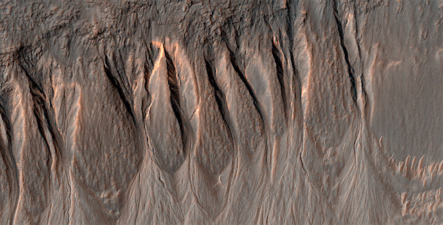
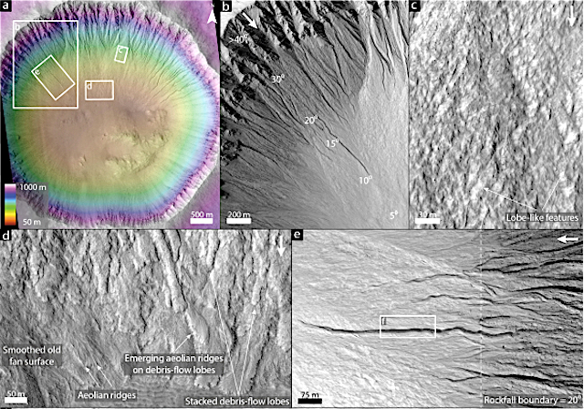
Planetary Geomorphology Image of the Month, May 31, 2017: T. de Has (Durham University). Martian gullies are composite landforms that comprise an alcove, channel and depositional fan. They are very young geological features, some of which have been active over the last million years. Water-free sediment flows, likely triggered by CO2 sublimation, debris flows, and fluvial flows have all been hypothesized to have formed gullies. These processes require very different amounts of liquid water, and therefore their relative contribution to gully-formation is of key importance for climatic inferences. Formative inferences based on surface morphology may be biased however, because of substantial post-depositional modification.

Many authors have used the surface morphology of gully-fans to infer the formative processes of gullies. In particular, the general absence of paired levees, distinct depositional snouts, and boulders >1 m in diameter, all characteristic of sediment-gravity flows such as debris flows and dry granular flows, has often been interpreted as evidence for gully-formation by fluvial flows. [More at link]
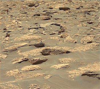
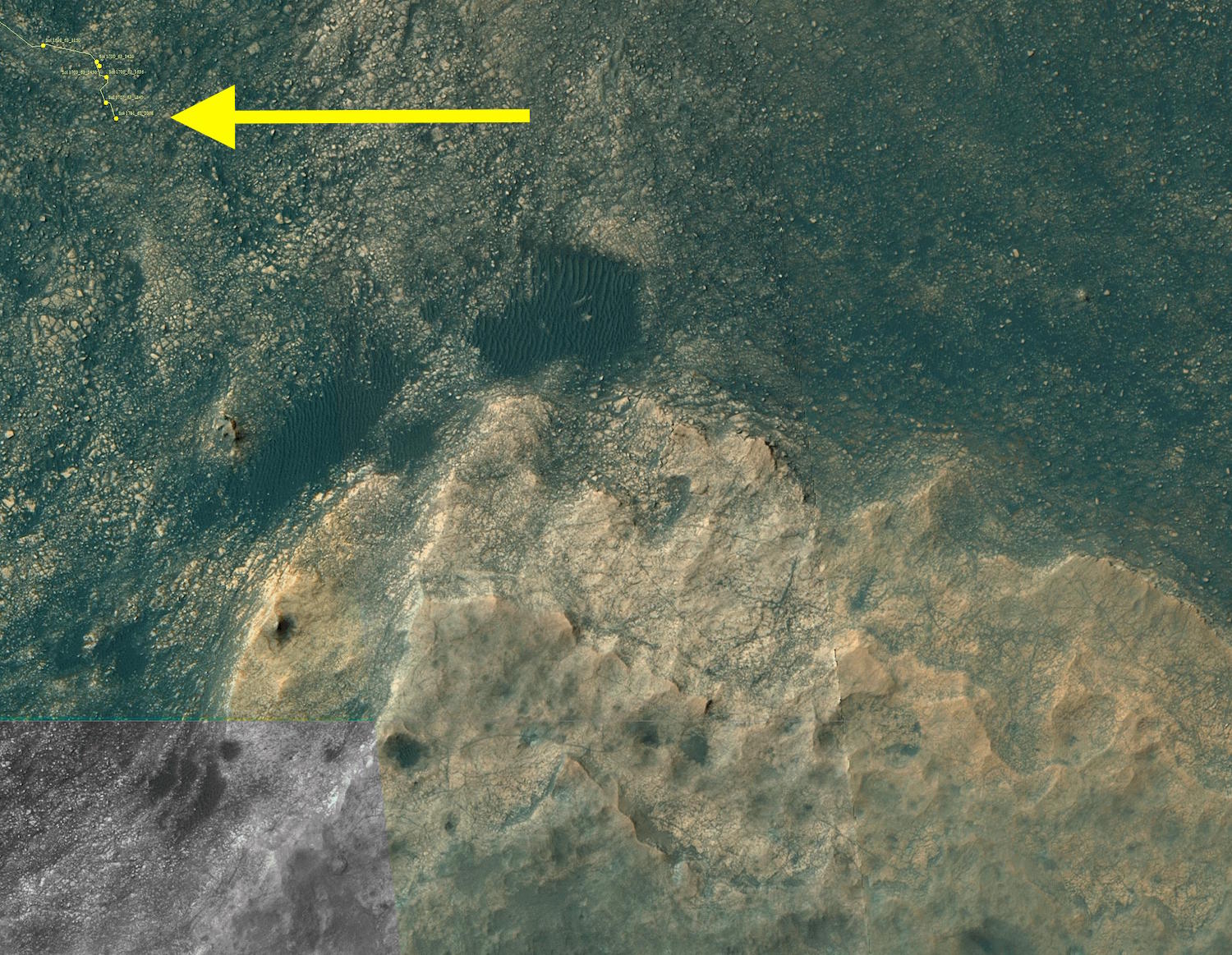
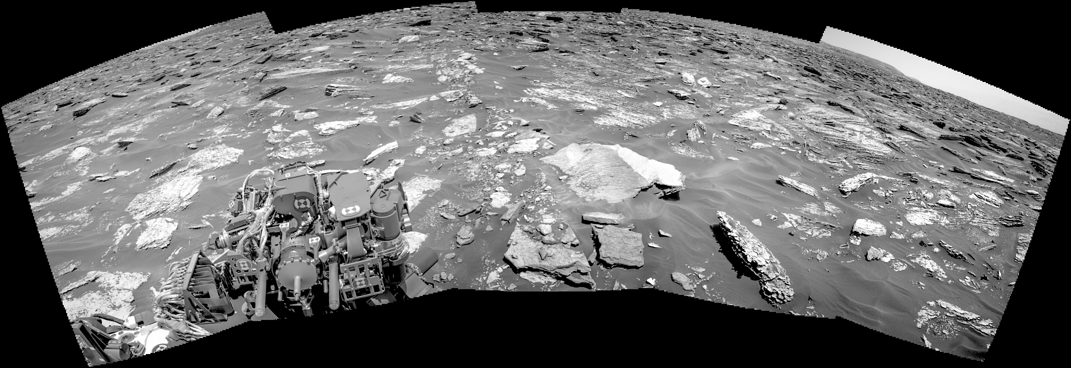
Posted in Reports | Tagged | Comments Off

Curiosity: Mastcam looks ahead

1711-mastcam34Sol_1711_loc_1200x900m-fullSol 1711, May 30, 2017. Using its 34 mm lens, the rover’s Mastcam shot a composite showing the way ahead toward more thinly bedded rocks. At right is Curiosity’s progress toward Vera Rubin Ridge (bottom). Click either image to enlarge it.

Sol 1711 raw images (from all cameras), and Curiosity’s latest location.

Posted in Reports | Tagged , , , , , , , , | Comments Off

THEMIS: Sand pile in Rabe Crater

Sand pile in Rabe Crater (THEMIS_IOTD_20170531)THEMIS Image of the Day, May 31, 2017. Today’s false color image shows part of the floor of Rabe Crater, including part of the dune field. Rabe Crater is located in Noachis Terra. The dunes’ blue tint in the image suggests the sand is made of grains of basalt, a volcanic rock common on Mars.

The THEMIS VIS camera contains 5 filters. The data from different filters can be combined in multiple ways to create a false color image. These false color images may reveal subtle variations of the surface not easily identified in a single band image.

More THEMIS Images of the Day by geological topic.

Posted in Reports | Tagged , , , , , , , , | Comments Off