Opportunity: At the valley’s head

4733-navcam-southSol 4733, May 18, 2017. With Opportunity perched at the top of the slope leading down into Perseverance Valley, mission scientists and rover drivers are imaging the terrain all around the rover. Above, the view toward the south with Winnemucca mesa standing high, while below is a view back toward the north showing the heights of Cape Tribulation. (Click either image to enlarge it.)

In places, small deposits of loose material have collected into dune-forms. Some of them appear bright in these Navcam views, matching the bright areas atop Winnemucca mesa. While the rover won’t get a chance to explore Winnemucca at close range, these nearby deposits may be similar to those up on the mesa.

Opportunity raw images, its latest mission status, location map, and atmospheric opacity, known as tau.

4733-navcam-north

Posted in Reports | Tagged , , , , , , , , , , | Comments Off

HiRISE: Hebes Chasma bedrock

tumblr_oq01zk9fTb1rlz4gso1_1280Hebes Chasma bedrock. Beautiful Mars series.

Posted in Reports | Tagged , , , , , , , , , | Comments Off

Tornado-like winds from impacts scoured surface

Santa Fe Infrared
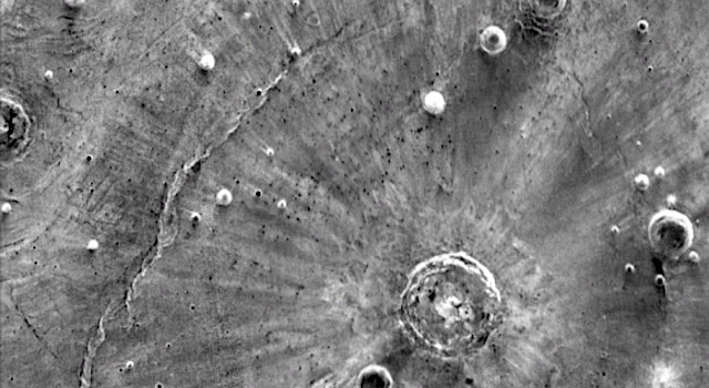
Plumes of vapor generated by ancient impacts on Mars created tornado-like winds possibly swirling at more than 500 miles per hour, which explain mysterious streaks seen near large impact craters on the Martian surface.

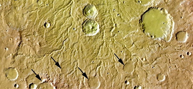
In looking at NASA images of Mars a few years ago, Brown University geologist Peter Schultz noticed sets of strange bright streaks emanating from a few large-impact craters on the planet’s surface. The streaks are odd in that they extend much farther from the craters than normal ejecta patterns, and they are only visible in thermal infrared images taken during the Martian night.

Using geological observation, laboratory impact experiments and computer modeling of impact processes, Schultz and Brown graduate student Stephanie Quintana have offered a new explanation for how those streaks were formed. The researchers show that tornado-like wind vortices — generated by crater-forming impacts and swirling at 500 miles per hour or more — scoured the surface and blasted away dust and small rocks to expose the blockier surfaces beneath.

“This would be like an F8 tornado sweeping across the surface,” Schultz said. “These are winds on Mars that will never be seen again unless another impact.”

The research is published online in the journal Icarus.

Schultz says he first saw the streaks during one of his “tours of Mars.” In his downtime between projects, he pulls up random images from NASA’s orbital spacecraft just to see if he might spot something interesting. In this case, he was looking at infrared images taken during the Martian nighttime by the THEMIS instrument, which flies aboard the Mars Odyssey orbiter. [More at links]
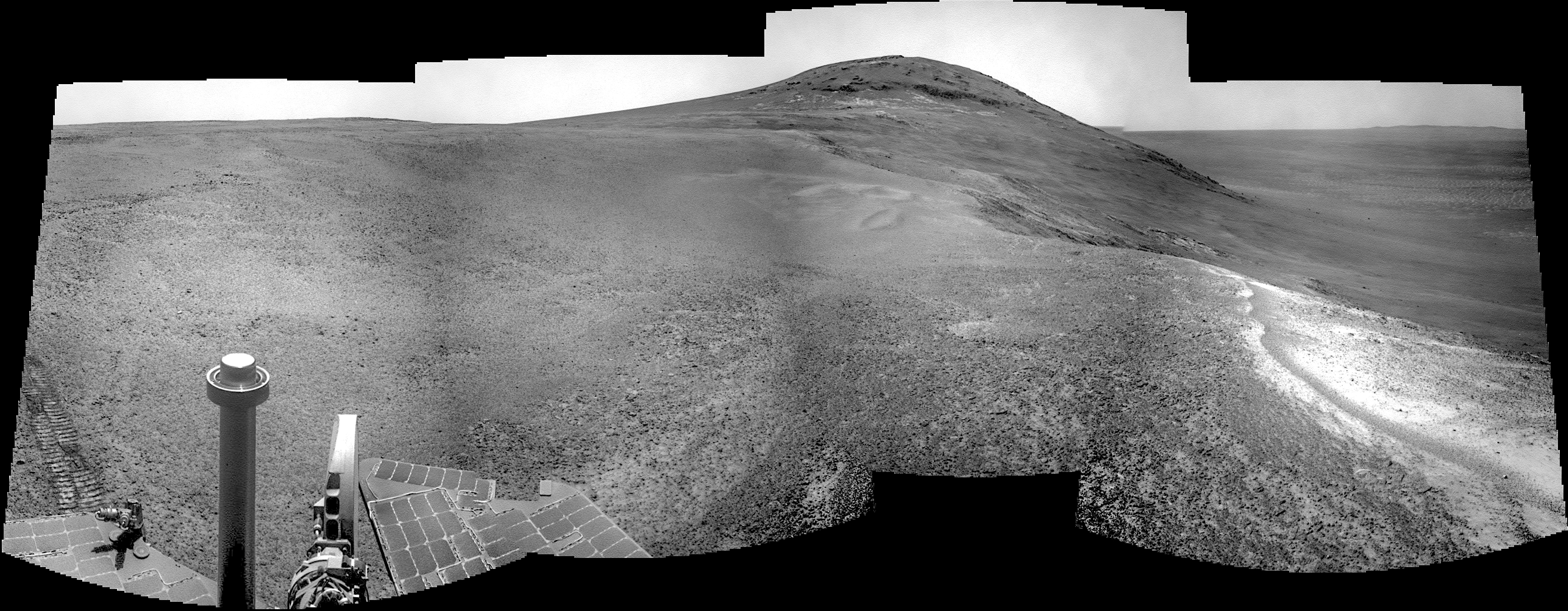
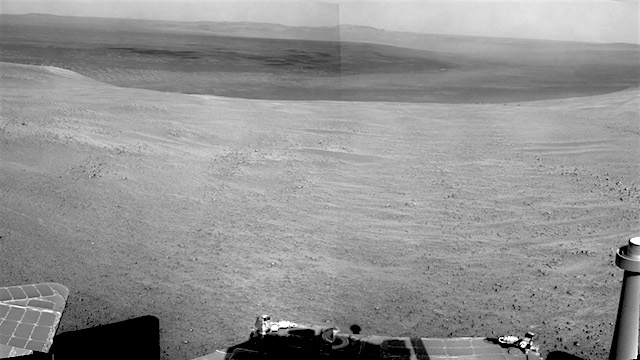
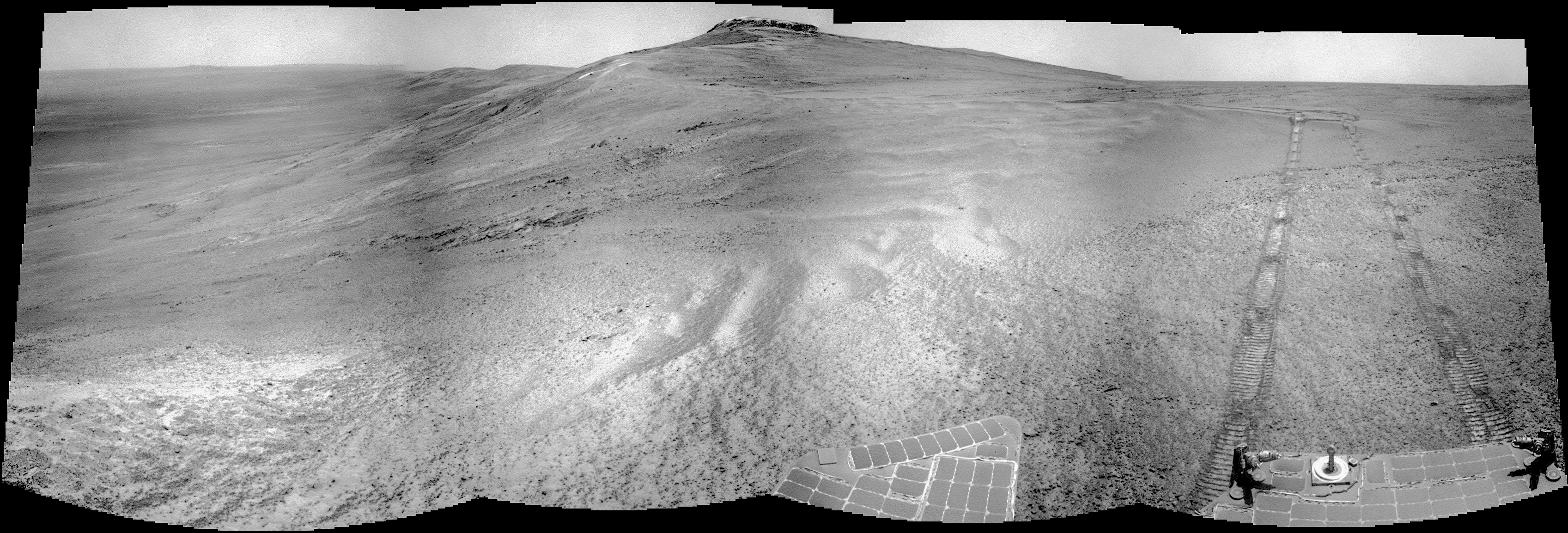
Posted in Reports | Tagged , , , | Comments Off

THEMIS: Among the Badlands of Cavi Angusti

Badlands of Cavi Angusti (THEMIS_IOTD_20170518)THEMIS Image of the Day, May 18, 2017. This is another VIS image showing late afternoon shadows. This image is located in Cavi Angusti, an area of extensive badlands in the southern highlands of Mars.

More THEMIS Images of the Day by geological topic.

Posted in Reports | Tagged , , , , , , , , | Comments Off

MARCI weather report, May 8-14, 2017

may-12-2017Short-lived local-scale dust storms continued to sweep over the southern high-latitudes of Mars this past week. In the northern plains, a mix of water-ice clouds and transient dust storms continued along the margin of the seasonal north polar ice cap, which has receded to ~59°N latitude. Condensate water-ice clouds lingered over the Tharsis… [More at link, including video]

Posted in Reports | Tagged , , , , , , , , , , , , , | Comments Off

HiRISE: Landslide!

ESP_050033_1920This image finally completes a stereo pair with another observation acquired in 2007. It shows a fresh (well-preserved) landslide scarp and rocky deposit off the edge of a streamlined mesa in Simud Valles, a giant outflow channel carved by ancient floods.

The stereo images can be used to measure the topography, which in turn constrains models for the strength of the mesa’s bedrock. Do look at the stereo anaglyph. [More at link]

Posted in Reports | Tagged , , , , , , , , | Comments Off

How hard did it rain on Mars?

How-hard-did-it-rain-on-MarsHeavy rain on Mars reshaped the planet’s impact craters and carved out river-like channels in its surface billions of years ago, according to a new study published in Icarus.

In the paper, researchers from the Smithsonian Institution and the Johns Hopkins University Applied Physics Laboratory show that changes in the atmosphere on Mars made it rain harder and harder, which had a similar effect on the planet’s surface as we see on Earth.

The fourth planet from the sun, Mars has geological features like the Earth and moon, such as craters and valleys, many of which were formed through rainfall. Although there is a growing body of evidence that there was once water on Mars, it does not rain there today.

But in their new study, geologists Dr. Robert Craddock and Dr. Ralph Lorenz show that there was rainfall in the past – and that it was heavy enough to change the planet’s surface. To work this out, they used methods tried and tested here on Earth, where the erosive effect of the rain on the Earth’s surface has important impacts on agriculture and the economy. [More at links]

Posted in Reports | Tagged , , , | Comments Off

Curiosity update: It’s touch-and-go on the climb to Vera Rubin Ridge

NLB_548058260EDR_F0630766NCAM00375M_-br2Sol 1698-99, May 16, 2017, update by MSL scientist Scott Guzewich: The road to Vera Rubin Ridge, a feature believed to be enriched in the mineral hematite, is getting steeper, so we are stopping frequently to study the composition of the bedrock beneath our wheels. Our intention is to use the APXS and ChemCam instruments to analyze the bedrock for every 5 meters of vertical elevation gain to see how it may change as we climb toward Vera Rubin Ridge. And we are climbing fast on many of our drives now! Today I was the Environmental Science Theme Group Lead as we planned Sols 1698 and 1699. Our first activity was… [More at link]

Posted in Reports | Tagged , , , , , , , , , , , , | Comments Off

THEMIS: Dunes besiege Terra Sirenum crater

Terra Sirenum dunes (THEMIS_IOTD_20170517)THEMIS Image of the Day, May 17, 2017. Not all Martian sand dunes are located in craters. This VIS image shows dunes located on the plains of Terra Sirenum.

More THEMIS Images of the Day by geological topic.

Posted in Reports | Tagged , , , , , , , , , | Comments Off

Opportunity begins study of valley’s origin

PIA21495_hiresNASA’s Mars Exploration Rover Opportunity has reached the main destination of its current two-year extended mission — an ancient fluid-carved valley incised on the inner slope of a vast crater’s rim.

As the rover approached the upper end of “Perseverance Valley” in early May, images from its cameras began showing parts of the area in greater resolution than what can be seen in images taken from orbit above Mars.

“The science team is really jazzed at starting to see this area up close and looking for clues to help us distinguish among multiple hypotheses about how the valley formed,” said Opportunity Project Scientist Matt Golombek of NASA’s Jet Propulsion Laboratory, Pasadena, California.

The process that carved Perseverance Valley into the rim of Endeavour Crater billions of years ago has not yet been identified. Among the possibilities: It might have been flowing water, or might have been a debris flow in which a small amount of water lubricated a turbulent mix of mud and boulders, or might have been an even drier process, such as wind erosion. The mission’s main objective with Opportunity at this site is to assess which possibility is best supported by the evidence still in place. [More at link]

Posted in Reports | Tagged , , , , , , , | Comments Off