Curiosity update: A smooth planning day

NLB_546374136EDR_F0621776NCAM00375M_-br2
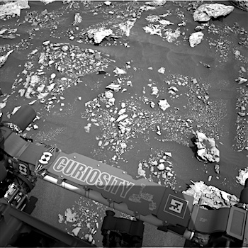
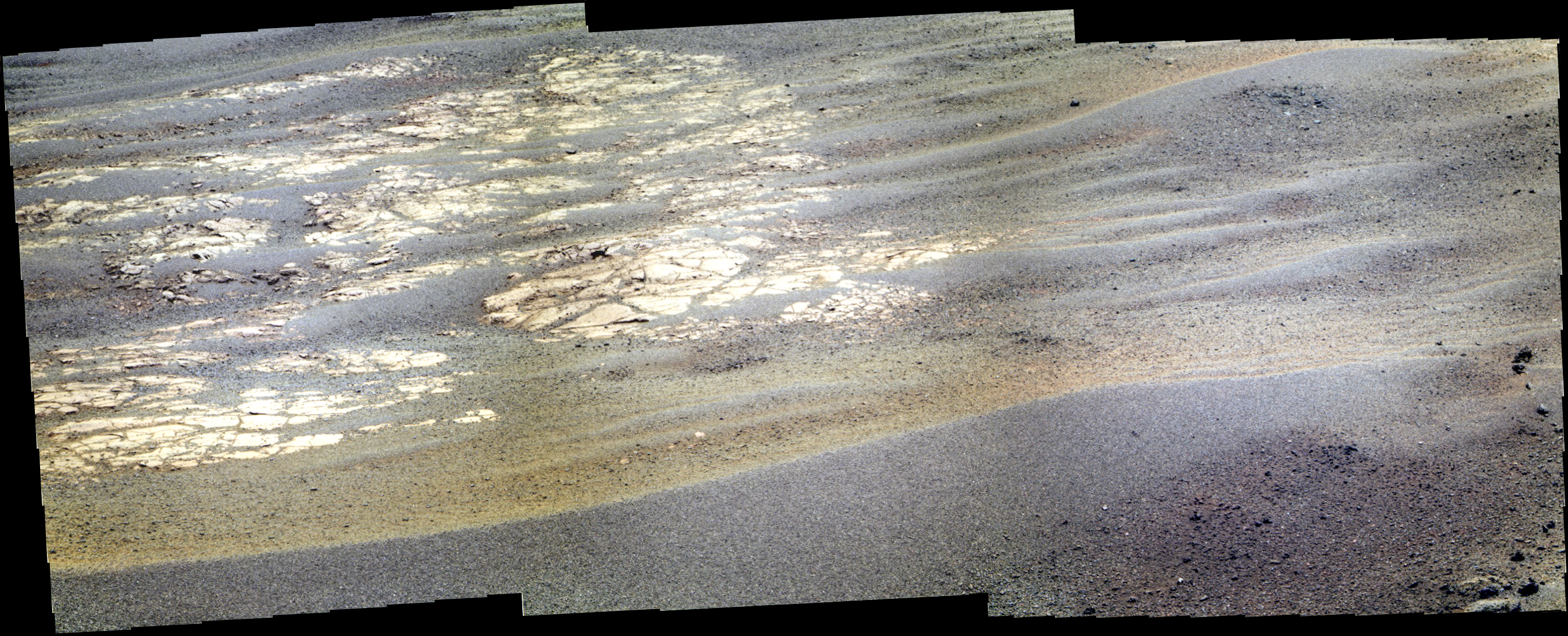
Sol 1678, April 26, 2017, update by MSL scientist Ken Herkenhoff: This MSL drove another 33 meters on Sol 1677, and again is surrounded by rocky outcrops partly covered by dark sand. Although Rover Planner support was available for “touch and go” contact science, the GEO science theme group decided that the limited reachable outcrop did not warrant contact science, and that driving is the top priority for this plan. APXS data were successfully acquired on Sol 1677, so are not urgently needed in this new location. The plan for Sol 1678 therefore focuses on remote sensing, with ChemCam 10×1 rasters on “Hancock Point,” a darker exposure of bedrock, and “Crocker Mountain,” a more normal-looking bedrock exposure. Mastcam context imaging of these targets will be… [More at link]

Posted in Reports | Tagged , , , , , , , , , | Comments Off

HiRISE: A volcanic fissure

ESP_019391_1960Although Mars is known for having the largest volcano in our Solar System, Olympus Mons, we also find small-scale volcanic features on its surface.

This fissure, less than 500 meters across at its widest point, lies in the Tharsis region and is believed to be a vent from which lava flowed in ancient eruptions.

The total volume of lava released from this fissure is much less than what would erupt from nearby volcanoes, but the mark left on the landscape is dramatic nonetheless. [More at link]

Posted in Reports | Tagged , , , , , , , , , | Comments Off

Curiosity: Rough pavement ahead

1678-navcamSol 1678, April 26, 2017. Curiosity has crossed the Bagnold Dune Field and is heading for Vera Rubin Ridge (formerly Hematite Ridge). As a result, the path ahead, as shown in the Navcam composite above, lies across slabby rocks with only small patches of sand between them. Click image to enlarge it.

Sol 1678 raw images (from all cameras), and Curiosity’s latest location.

Posted in Reports | Tagged , , , , , , , , , , | Comments Off

MARCI weather report, April 17-23, 2017

April-20-2017The red planet continued to display dust-lifting and water-ice clouds along the seasonal north polar ice cap edge this past week. The plains of Chryse and western Amazonis also experienced a local-scale dust storm or two in the second half of the week. Looking to the southern highlands, dust storm events pressed on affecting the regions from southern Promethei to southwest Argyre. As the seasons begin to transition from… [More at link, including video]

Posted in Reports | Tagged , , , , , , , , , , , , , | Comments Off

HiRISE: North Ismeniae Fossae scarp

tumblr_ookg8u4hH51rlz4gso2_1280North Ismeniae Fossae scarp. Beautiful Mars series.

Posted in Reports | Tagged , , , , , , , , | Comments Off

THEMIS: Aonia Terra crater ejecta in false color

Aonia craters in false color (THEMIS_IOTD_20170426)THEMIS Image of the Day, April 26, 2017. Today’s false color image shows several small craters in Aonia Terra. The false colors help show differences in the patterns of debris ejected in the impacts.

The THEMIS VIS camera contains 5 filters. The data from different filters can be combined in multiple ways to create a false color image. These false color images may reveal subtle variations of the surface not easily identified in a single band image.

More THEMIS Images of the Day by geological topic.

Posted in Reports | Tagged , , , , , , , , , , | Comments Off

Opportunity: Head of the valley just ahead

4711-pancamSol 4711, April 25, 2017. After a 36-meter (120-foot) drive to the southeast, the Pancam shows the head of Perseverance Valley as a shallow notch in the center of this three-frame composite. It lies about 100 meters (330 feet) away. The dark feature at left is rubble in a small, relatively fresh impact crater. Click image to enlarge it.

Opportunity raw images, its latest mission status, a location map, and atmospheric opacity, known as tau.

Posted in Reports | Tagged , , , , , , | Comments Off

HiRISE: Windblown sand in Ganges Chasma

ESP_019507_1725Dark, windblown sand covers intricate sedimentary rock layers in this image from Ganges Chasma, a canyon in the Valles Marineris system.

These features are at once familiar and unusual to those familiar with Earth’s beaches and deserts. Most sand dunes on Earth are made of silica-rich sand, giving them a light color; these Martian dunes owe their dark color to the iron and magnesium-rich sand found in the region.

Posted in Reports | Tagged , , , , , , , , , , , , | Comments Off

Mars’ big-impact history had a post-accretion lull

mars-impact_0From the earliest days of our solar system’s history, collisions between astronomical objects have shaped the planets and changed the course of their evolution. Studying the early bombardment history of Mars, scientists at Southwest Research Institute (SwRI) and the University of Arizona have discovered a 400-million-year lull in large impacts early in Martian history.

This discovery is published in the latest issue of Nature Geoscience in a paper titled, “A post-accretionary lull in large impacts on early Mars.” SwRI’s Dr. Bill Bottke, who serves as principal investigator of the Institute for the Science of Exploration Targets (ISET) within NASA’s Solar System Exploration Research Virtual Institute (SSERVI), is the lead author of the paper. Dr. Jeff Andrews-Hanna, from the Lunar and Planetary Laboratory in the University of Arizona, is the paper’s coauthor.

“The new results reveal that Mars’ impact history closely parallels the bombardment histories we’ve inferred for the Moon, the asteroid belt, and the planet Mercury,” Bottke said. “We refer to the period for the later impacts as the ‘Late Heavy Bombardment.’ The new results add credence to this somewhat controversial theory. However, the lull itself is an important period in the evolution of Mars and other planets. We like to refer to this lull as the ‘doldrums.’” [More at links]

Posted in Reports | Tagged , , , , , | Comments Off

Opportunity: Rover backtrail

4710-navcamSol 4710, April 24, 2017. The Navcam shot a semi-pan looking back north and showing the rover’s tracks as it came down from Cape Tribulation and across the level separating that cape from the next one south, Cape Byron. The interior of Endeavour Crater lies to the right, while the plains of Meridiani Planum extend to the left.

Below is a three-frame Pancam false-color composite from Sol 4709 (by Holger Isenberg) of the exposed bedrock-and-sand-ripple at left center in the image above. Click either image to enlarge it.

Opportunity raw images, its latest mission status, a location map, and atmospheric opacity, known as tau.

4709-pancam

Posted in Reports | Tagged , , , , , , | Comments Off