A geological history of NE Syrtis Major

NE_Syrtis_HiRISE_IRB_2_scalecrop2Brown University researchers have published the most detailed geological history to date for a region of Mars known as Northeast Syrtis Major, a spot high on NASA’s list of potential landing sites for its next Mars rover to be launched in 2020.

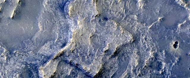
The region is home to a striking mineral diversity, including deposits that indicate a variety of past environments that could have hosted life. Using the highest resolution images available from NASA’s Mars Reconnaissance Orbiter, the study maps the extent of those key mineral deposits across the surface and places them within the region’s larger geological context.

“When we look at this in high resolution, we can see complicated geomorphic patterns and a diversity of minerals at the surface that I think is unlike anything we’ve ever seen on Mars,” said Mike Bramble, a Ph.D. student at Brown who led the study, which is published in the journal Icarus. “Within a few kilometers, there’s a huge spectrum of things you can see and they change very quickly.” [More at links]

Posted in Reports | Tagged , , , , | Comments Off

THEMIS: Proctor Crater’s sheet of sand dunes

Proctor Crater dunes (THEMIS_IOTD_201700421)THEMIS Image of the Day, April 21, 2017. Today’s false color image shows a portion of the large sand sheet with surface dune forms located on the floor of Proctor Crater in Noachis Terra.

The THEMIS VIS camera contains 5 filters. The data from different filters can be combined in multiple ways to create a false color image. These false color images may reveal subtle variations of the surface not easily identified in a single band image.

More THEMIS Images of the Day by geological topic.

Posted in Reports | Tagged , , , , , , , , , | Comments Off

Curiosity: Amid slabs of rock

1672-navcamSol 1672, April 20, 2017. Curiosity drove 23 meters (76 feet) to the south and halted amid a field of thin-layered slabby rocks, part of the Murray Formation. Click image to enlarge it.

Sol 1672 raw images (from all cameras), and Curiosity’s latest location.

Posted in Reports | Tagged , , , , , , , | Comments Off

HiRISE: It shrinks! It cracks!

ESP_049723_1880Given enough time, impact craters on Mars tend to fill up with different materials. For instance, some craters on Mars had lakes inside them in the past. When these lakes dried out, they left behind traces of their past existence, such as sedimentary deposits (materials that were carried along with the running water into the lake inside the crater and then settled down). Some craters, especially in high latitudes, contain ice deposits that filled the crater when an earlier ice age allowed ice to extend into the crater’s latitude.

Here, we have a crater that lies close to Elysium, a major volcanic system on Mars. The whole region surrounding the crater was at some point covered by lava from the volcano creating vast lava plains, and in the process, flooding impact craters in their way. [More at link]

Posted in Reports | Tagged , , , , , , , | Comments Off

Opportunity: Heading for the valley

4705-navcam1P545879069ESFCXT8P2575L5M1_L4L5L5L5L6Sol 4705, April 19, 2017. The Navcam shows the way forward toward the head of Perseverance Valley, with Winnemucca mesa beyond. At right is a false-color view of the RATted area at Ogalalla (Holger Isenberg). Click either image to enlarge it.

Opportunity raw images, its latest mission status, a location map, and atmospheric opacity, known as tau.

Posted in Reports | Tagged , , , , , , , | Comments Off

THEMIS: Matara Crater’s sand dunes

Matara Crater sand dunes (THEMIS_IOTD_20170420)THEMIS Image of the Day, April 20, 2017. Today’s false color image shows the sand sheet with surface dune forms on the floor of Matara Crater in Noachis Terra. Blue false color suggests basaltic sand, and Matara Crater is one of countless sand traps in the ancient terrain of Noachis Terra.

The THEMIS VIS camera contains 5 filters. The data from different filters can be combined in multiple ways to create a false color image. These false color images may reveal subtle variations of the surface not easily identified in a single band image.

More THEMIS Images of the Day by geological topic.

Posted in Reports | Tagged , , , , , , , , , , | Comments Off

Opportunity leaves Cape Tribulation

NASA’s senior Mars rover, Opportunity, is departing “Cape Tribulation,” a crater-rim segment it has explored since late 2014, southbound for its next destination, “Perseverance Valley.” The rover team plans observations in the valley to determine what type of fluid activity carved it billions of years ago: water, wind, or flowing debris lubricated by water.

A color panorama of a ridge called “Rocheport” provides both a parting souvenir of Cape Tribulation and also possible help for understanding the valley ahead. The view was assembled from multiple images taken by Opportunity’s panoramic camera.

“The degree of erosion at Rocheport is fascinating,” said Opportunity Deputy Principal Investigator Ray Arvidson, of Washington University in St. Louis. “Grooves run perpendicular to the crest line. They may have been carved by water or ice or wind. We want to see as many features like this on the way to Perseverance Valley as we can, for comparison with what we find there.”

Perseverance Valley is about two football fields long. It cuts downward west to east across the western rim of Endeavour Crater. The crater is about 14 miles (22 kilometers) in diameter, with a segmented rim that exposes the oldest rocks ever investigated in place on Mars. Opportunity has less than four football fields’ distance of driving to reach the top of the valley after departing Cape Tribulation, a raised segment about 3 miles (5 kilometers) long on the crater’s western rim. [More at link]

Posted in Reports | Tagged , , , , , , , | Comments Off

MARCI weather report, April 10-16, 2017

april-12-2017For the past week on Mars, local-scale dust storms continued to develop over the southern high-latitudes. During that time, small short-lived dust storms were observed moving eastward over the seasonal north polar ice cap edge, which are typical this time of Mars year. Dust hazes associated with this activity dipped south over the plains of Acidalia and northern Utopia on some sols. Condensate water-ice clouds over the Tharsis Montes… [More at link, including video]

Posted in Reports | Tagged , , , , , , , , , , , , , | Comments Off

Curiosity: At Jellison Cove

1671-navcamSol 1671, April 19, 2017. After a short drive, Curiosity stands on a large rock outcrop dubbed Jellison Cove. Click image to enlarge it.

Sol 1671 raw images (from all cameras), and Curiosity’s latest location.

Posted in Reports | Tagged , , , , , , , , , | Comments Off

HiRISE: Dune transition in high southern latitudes

ESP_049502_1080Sand dune populations on Mars can vary widely with respect to morphology, relief, and activity. One of the most striking examples occurs with the many dune fields of the high Southern latitudes.

When we venture south of -60 degrees latitude, we see increasing signs of dune degradation, with subdued dune brinks and broad sandy aprons, rather than sharp, dune crests and distinct boundaries. Dunes this far south are also very modest in height, often consisting solely of flat sand sheets. Additionally, global monitoring campaigns are revealing a noticeable lack of changes in these bedform positions, whereas many dunes and ripples to the north are migrating across the surface. [More at link]

Posted in Reports | Tagged , , , , , , , | Comments Off