HiRISE: A closer look at Holden Crater

PSP_003077_1530
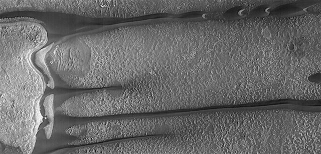
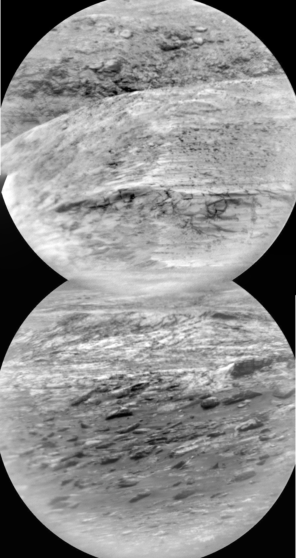
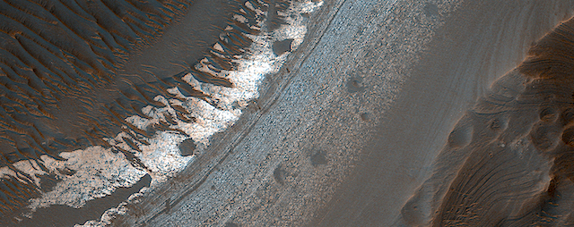
Holden Crater in southern Margaritifer Terra displays a series of finely layered deposits on its floor (white and light purple in an enhanced color image). The layered deposits are especially well exposed in the southwestern section of the crater where erosion by water flowing through a breach in the crater rim created spectacular outcrops.

In this location, the deposits appear beneath a cap of alluvial fan materials (tan to brown in this image). Within the deposits, individual layers are nearly flat-lying and can be traced for hundreds of meters to kilometers. Information from the CRISM instrument on the Mars Reconnaissance Orbiter suggests that at least some of these beds contain clays. [More at link]

Posted in Reports | Tagged , , , , , , , , , , , | Comments Off

ExoMars: Noctis Labyrinthus stereo pair

Noctis_Labyrinthus_stereo_pairExoMars was launched on a Proton-M rocket from Baikonur, Kazakhstan on 14 March 2016. Around seven months later, it arrived at Mars.

As part of preparations for its main science mission to analyse the atmosphere for gases that may be related to biological or geological activity, and image sites that might be related to these sources, the Trace Gas Orbiter has conducted two campaigns to test its science instruments – one last November and one last week. (…)

The images together form a stereo pair of part of the Noctis Labyrinthus region of Mars. The camera takes one image looking slightly forwards (bottom image in this orientation), and then, after having flown over the area, it rotates to look ‘back’ to take the second part of the image (top), in order to see the same region of the surface from two different angles. [More at link]

Posted in Reports | Tagged , , , , , , , , , | Comments Off

MARCI weather report, March 6-12, 2017

march-8-2017Regional storm activity continued over Xanthe Terra as last week’s regional storm parked itself over the equator, just west of the Opportunity rover site. The storm extended from Chryse Planitia in the north to northwest Noachis in the southern hemisphere, covering an area about the size of the continental United States. Further south, remnants of the previous month’s major dust storm were observed as diffuse hazes at southern mid-latitudes. Looking to the northern hemisphere, polar hood clouds continued to dissipate revealing the bright… [More at link, including video]

Posted in Reports | Tagged , , , , , , , , , , , , , | Comments Off

Opportunity: Rolling southward

4670-navcamSol 4670, March 14, 2017. With the Pancam continuing its scouting-ahead role, the rover drove 36 meters (117 feet) toward the south and the next target of science interest, Perseverance Valley. Click image (1.3 MB) to enlarge it.

Opportunity raw images, its latest mission status, a location map, and atmospheric opacity, known as tau.

Posted in Reports | Tagged , , , , , , | Comments Off

THEMIS: Secondary craters in Margaritifer Terra

Variegated plains in Margaritifer (themis_iotd_20170315)THEMIS Image of the Day, March 15, 2017. Today’s false color image shows part of the plains of Margaritifer Terra. The swarm of craters at right was likely produced by the impact of debris ejected from a bigger impact elsewhere on Mars.

The THEMIS VIS camera contains 5 filters. The data from different filters can be combined in multiple ways to create a false color image. These false color images may reveal subtle variations of the surface not easily identified in a single band image.

More THEMIS Images of the Day by geological topic.

Posted in Reports | Tagged , , , , , , , , | Comments Off

HiRISE: Fans and crater floor deposits southeast of Vinogradov Crater

ESP_016843_1590This white, purple, and pink surface is located on the floor of an impact crater on the southeast rim of the larger Vinogradov Crater in southern Margaritifer Terra.

The surface consists of what is left of a series of thin layers that subsequently eroded to create a “bullseye” pattern. The rough, etched appearance of the surface is similar-looking to deposits in other craters in the region and that are often associated with alluvial fans. The apparent ease and manner in which the materials are eroded relative to nearby fans and crater materials suggests they are fine-grained and the dominant agent of erosion is the wind. [More at link]

Posted in Reports | Tagged , , , , , , , , , , , , , | Comments Off

Curiosity update: Stop 3

NLB_542734271EDR_F0612232NCAM00283M_-br2Sol 1637, March 14, 2017, update by USGS scientist Ryan Anderson: Yesterday’s short drive was successful, so we started today with the rover parked at stop #3 of the dune campaign and the rover’s arm up in the “ready out” position. The Sol 1637 plan starts out with a couple of Mastcam atmospheric observations, followed by ChemCam analysis of two targets on a nearby sand ripple. The target “Spragueville” is in the ripple trough and “Ripogenus” is on the ripple crest. Mastcam will document both targets, and will take a couple of small… [More at link]

Posted in Reports | Tagged , , , , , , , , , , , , , | Comments Off

HiRISE: Barchan dune changes

tumblr_ombljs0uLL1rlz4gso1_1280Barchan dune changes in the Hellespontus region. Beautiful Mars series.

Posted in Reports | Tagged , , , , , , , , , | Comments Off

Curiosity: Surroundings, near and far

1636-navcam-NW1636-rmiSol 1636, March 14, 2017. On a sol with a short (15-foot) drive to the west-southwest, the rover’s Navcam took composite pans to the northwest (above) and southeast (below).

Just before the drive, the Remote Micro-Imager profiled part of Mt. Sharp’s layers (right). Click any image to enlarge it.

Sol 1636 raw images (from all cameras), and Curiosity’s latest location.

1636-navcam-SE

Posted in Reports | Tagged , , , , , , , , | Comments Off

Opportunity field report, March 13, 2017

4669_PancamSol 4669, March 13, 2017; Rover Field Report by Larry Crumpler, MER Science Team & New Mexico Museum of Natural History & Science: Opportunity has begun the drive down the long descending southward slope of the rim crest here. The destination is a notch in the rim of Endeavour crater which is also the head of a small and ancient water-cut valley. There is a good view south along the rim from this location, although a dusty one. (…)

The Pancam panorama looking south and the drive ahead shows where we are going. The bright mesa-like feature is over 800 meters away and just a 100 meters or so beyond the point where Opportunity is headed. You can also see the significant “hole” of the crater to the left of the rim. Notice that the regional dust storm is seriously impacting visiblity, as it is power. [More at link]

Posted in Reports | Tagged , , , , , , , | Comments Off