


 THEMIS Image of the Day, October 28, 2016. This VIS image shows part of the large sand sheet within Proctor Crater. The surface of the sand sheet hosts dune forms.
More THEMIS Images of the Day by geological topic.
THEMIS Image of the Day, October 28, 2016. This VIS image shows part of the large sand sheet within Proctor Crater. The surface of the sand sheet hosts dune forms.
More THEMIS Images of the Day by geological topic.
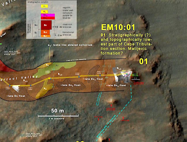 Sol 4535, October 26, 2016; Rover Field Report by Larry Crumpler, MER Science Team & New Mexico Museum of Natural History & Science: Since the last report, Opportunity has driven into the next valley to the south which we have informally named “Bitteroot Valley.”
On this sol Opportunity is finishing up observations on the first outcrop target of its 10th mission extension plan. In this two-year plan Opportunity will explore the lower inner walls of Endeavour crater. It will then climb back out to the west and south while exploring the stratigraphy and structure of the crater wall, and then, drive south along the rim.
Later in the year the plan is for Opportunity to drive back into the crater, following the floor of a fluvial channel cut in the rim of the crater. If Opportunity is able to follow this plan, then this will be the first drive inside a known fluvial channel on Mars. The results should be interesting. [More at link]
[Editor note: More at the ExoMars and HiRISE sites]
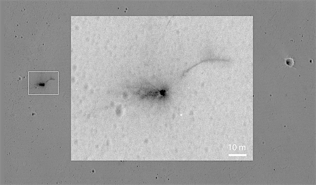
The most powerful telescope orbiting Mars is providing new details of the scene near the Martian equator where Europe’s Schiaparelli test lander hit the surface last week.
An Oct. 25 observation using the High Resolution Imaging Science Experiment (HiRISE) camera on NASA’s Mars Reconnaissance Orbiter shows three impact locations within about 0.9 mile (1.5 kilometers) of each other…
The scene shown by HiRISE includes three locations where hardware reached the ground. A dark, roughly circular feature [see image above] is interpreted as where the lander itself struck. A pattern of rays extending from the circle suggests that a shallow crater was excavated by the impact, as expected given the premature engine shutdown.
About 0.8 mile (1.4 kilometers) eastward, an object with several bright spots surrounded by darkened ground is likely the heat shield.
About 0.8 mile (1.4 kilometers) south of the lander impact site, two features side-by-side are interpreted as the spacecraft’s parachute and the back shell to which the parachute was attached. Additional images to be taken from different angles are planned and will aid interpretation of these early results. [More at links]
 Sol 1502, October 26, 2016, update by USGS scientist Ryan Anderson: Yesterday’s 46 meter drive went well, and the plan for Sol 1502 is to have another pretty typical remote sensing and driving sol. The Sol 1502 plan starts out with ChemCam observations of the bedrock target “St. Saveur” and an interesting transition between light-toned and dark-toned alteration called “The Tam”. Mastcam will document those two targets, and then collect mosaics of two Murray bedrock targets “Cranberry Island” and “Otter Cliff”. After that… [More at link]
 THEMIS Image of the Day, October 27, 2016. Today’s VIS image is of Palikir Crater in Terra Sirenum. The inner rim of the crater is dissected with numerous gullies. In higher resolution images from other imagers these gullies are the location of recurring slope lineae (RSLs), which appear to grow and retreat as seasons change.
More THEMIS Images of the Day by geological topic.
 Sol 4534, October 25, 2016. The Microscopic Imager’s latest target area is dubbed Lupus, named for a town in Missouri visited by the Lewis and Clark explorers. This is an area of soil disturbed by Opportunity’s right front wheel as the rover turned in place. Click image to enlarge it.
Opportunity raw images, its latest mission status, a location map. and atmospheric opacity, known as tau.
 [Editor note: Report by Elizabeth Gibney in Nature] Photos of a huge circle of churned-up Martian soil leave few doubts: a European Space Agency (ESA) probe that was supposed to test landing technology on Mars crashed into the red planet instead, and may have exploded on impact. (… )
Figuring out Schiaparelli’s faults and rectifying them is a priority, says Jorge Vago, project scientist for ExoMars. “That’s super important. I think it’s on everybody’s mind.”
(…) But at 4 minutes and 41 seconds into an almost 6-minute fall, something went wrong. The lander’s heat shield and parachute ejected ahead of time, says Vago. Then thrusters, designed to decelerate the craft for 30 seconds until it was metres off the ground, engaged for only around 3 seconds before they were commanded to switch off, because the lander’s computer thought it was on the ground. (…) The most likely culprit is… [More at link]
 Sol 1501, October 25, 2016, update by USGS scientist Lauren Edgar: On Sol 1500 Curiosity drove 30 m to the south, crossing into a quadrangle that we informally named “Bar Harbor,” after Bar Harbor, Maine. As a reminder, prior to landing we divided up the landing ellipse and nearby areas into square quads (1.5 km on a side), and assigned each quad a name of a town with a population of less than 100,000 people. As Curiosity investigates rock targets within a quad, we assign names to the targets that correspond to geologic formations and features from that town on Earth. After driving through the “Windhoek” quad for quite some time, we are now in the “Bar Harbor” quad, and the naming scheme will follow names from that town. [More at link]
 Local dust storms continued along the receding seasonal south polar ice cap edge this past week. Meanwhile, on the other side of the red planet, transient dust storms just south of the north polar hood were observed over Deuteronilus and northwestern Arabia Terra. Northeastern Hellas and Terra Sabaea also encountered some dust lifting activity at the beginning of the week. Typical for this time of season, afternoon water-ice clouds were… [More at link]
 THEMIS Image of the Day, October 26, 2016. The “tail” behind the crater at the top of this VIS image is called a windstreak. This feature is formed by winds blowing over, in, and around the crater. Turbulence in the wind will erode or deposit fine materials, creating the windstreak. Windstreaks form on the downwind side of the crater, and here the streak indicates winds from the ESE. The small hills below the windstreak are small volcanic constructs. This image is located in the extensive lava plains called Daedalia Planum.
More THEMIS Images of the Day by geological topic.