HiRISE: Edge of the south pole layered deposit

ESP_047087_1065This image shows the edge of the Martian South Polar layered deposit. The stack of fine layering is highlighted by the rays of the polar sun.

These layers show the pervasive red coloring of Mars which have built up over the ages. While this is a polar deposit, no ice or frost is visible on these layers, as they face the sun. However, if you look beyond the rim of the layered slope at the ‘top’ of the deposit, you can see that red rock and dust are covered with frost, as well as small radial channels that are evidence of polar spider networks. [More at link]

Posted in Reports | Tagged , , , , , , , | Comments Off

Curiosity update: Cleaning CheMin

1484MH0003120010504473C00_DXXXSol 1487-88, October 10, 2016, update by USGS scientist Ken Herkenhoff: While some of us enjoyed the Columbus Day holiday, MSL continued working on Mars.  The rover drove over 36 meters on Sol 1485, and another drive is planned for Sol 1487.  But first, ChemCam and Mastcam will observe vein and bedrock targets named “Palapye,” “Tutume,” “Shoshong,” and “Molepolole.”  The Right Mastcam will also acquire mosaics of … [More at link]

Posted in Reports | Tagged , , , , , , , , , , , , , , , | Comments Off

THEMIS: Erased crater (?) in Terra Sabaea

Eradicated crater in Terra Sabaea (THEMIS_IOTD)20161012)THEMIS Image of the Day, October 12, 2016. Today’s false color image shows part of the plains in Terra Sabaea with what may be an ancient, almost eradicated crater. The THEMIS VIS camera contains 5 filters. The data from different filters can be combined in multiple ways to create a false color image. These false color images may reveal subtle variations of the surface not easily identified in a single band image.

More THEMIS Images of the Day by geological topic.

Posted in Reports | Tagged , , , , , , , , | Comments Off

HiRISE: Transition from depressed to inverted channels in Gorgonum Basin

ESP_046201_1430This image shows a transition from depressed to inverted channels in the Gorgonum Basin. In the darker terrain, there are two channels that display depressed topography. As these two channels cross into the underlying brighter terrain, the channels now stand above the surrounding area, indicating they are inverted in topography.

This change from depressed to inverted topography is the result of what is called “differential erosion.” The channel may contain hardened sediments or have cements that make it more resistant to erosion relative to the darker terrain that once flowed through it. As a result, erosion has removed the less… [More at link]

Posted in Reports | Tagged , , , , , , , , | Comments Off

THEMIS: Dust devil tracks across Terra Cimmeria

Dust devil tracks across Cimmeria (THEMIS_IOTD_20161011)THEMIS Image of the Day, October 11, 2016. Today’s false color image shows dust devil tracks (the dark blue linear features) in Terra Cimmeria. The THEMIS VIS camera contains 5 filters. The data from different filters can be combined in multiple ways to create a false color image. These false color images may reveal subtle variations of the surface not easily identified in a single band image.

More THEMIS Images of the Day by geological topic.

Posted in Reports | Tagged , , , , , , , , | Comments Off

HiRISE: Long and winding channel in Tharsis

ESP_045368_2040The Tharsis region of Mars is covered in vast lava flows, many with channels. Some channels, however, resemble features that may have been formed by water.

In this image, we see a smooth, flat-bottomed channel within the roughly irregular edges of a possible lava flow. This long, winding channel runs for 115 kilometers (70 miles) from its source (shown in ESP_045091_2045), maintaining a nearly consistent width. There is also a streamlined island within the channel, which is 1.25 kilometers (about 3/4 mile) long.

One possibility is that a lava flow formed, and later groundwater was released, preferentially flowing through and further eroding the pre-existing lava… [More at link]

Posted in Reports | Tagged , , , , , , , , | Comments Off

THEMIS: Yuty Crater’s splashy debris pattern

Yuty Crater impact into ice-rich ground (THEMIS_IOTD_20161010)THEMIS Image of the Say, October 10, 2016. This VIS image shows part of the ejected debris around Yuty Crater. The ejecta, with the raised outer margin, is called a rampart. It comes from water- or ice-rich ground where the impact occurred, which makes the ejected debris move more easily.

More THEMIS Images of the Day by geological topic.

Posted in Reports | Tagged , , , , , , , , , | Comments Off

Curiosity update: Dropping off samples to SAM

1482ML0074450020603580E01_DXXXSol 1484-86, October 7, 2016, update by USGS scientist Ken Herkenhoff: The MSL rover made another 40 meters of progress up the flank of Mt. Sharp on Sol 1482, and there were multiple bedrock blocks within reach of the arm for the weekend plan.  A smooth patch on a nearby block was selected for DRT brushing and associated imaging, and named “Serowe.”  The Sol 1484 plan also includes two dropoffs of… [More at link]

Posted in Reports | Tagged , , , , , , , , , , , | Comments Off

Opportunity to descend Bitterroot Valley

IDL TIFF fileNASA’s Opportunity Mars rover will drive down a gully carved long ago by a fluid that might have been water, according to the latest plans for the 12-year-old mission. No Mars rover has done that before.

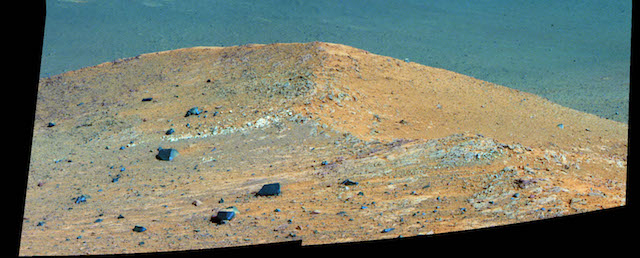
The longest-active rover on Mars also will, for the first time, visit the interior of the crater it has worked beside for the last five years. These activities are part of a two-year extended mission that began Oct. 1, the newest in a series of extensions going back to the end of Opportunity’s prime mission in April 2004. (…)

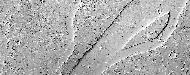
Opportunity begins its latest extended mission in the “Bitterroot Valley” portion of the western rim of Endeavour Crater, a basin 14 miles (22 kilometers) in diameter that was excavated by a meteor impact billions of years ago…. The gully chosen as the next major destination slices west-to-east through the rim about half a mile (less than a kilometer) south of the rover’s current location. It is about as long as two football fields.

“We are confident this is a fluid-carved gully, and that water was involved,” said Opportunity Principal Investigator Steve Squyres of Cornell University, Ithaca, New York. “Fluid-carved gullies on Mars have been seen from orbit since the 1970s, but none had been examined up close on the surface before. One of the three main objectives of our new mission extension is to investigate this gully. We hope to learn whether the fluid was a debris flow, with lots of rubble lubricated by water, or a flow with mostly water and less other material.”

The team intends to drive Opportunity down the full length of the gully, onto the crater floor….. [More at link]
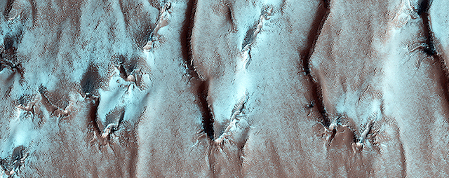
Posted in Reports | Tagged , , , , , , , | Comments Off

ExoMars: Schiaparelli being readied for landing

ESA ExoMars 2016This week, the commands that will govern the Schiaparelli lander’s descent and touchdown on Mars were uploaded to ESA’s ExoMars spacecraft, en route to the Red Planet.

The Trace Gas Orbiter has been carrying the Schiaparelli entry, descent and landing demonstrator since launch on 14 March. Upon arrival on 19 October, Schiaparelli will test the technology needed for Europe’s 2020 rover to land, while its parent craft brakes into an elliptical orbit around Mars.

This week’s uploading was conducted by the Orbiter team working at ESA’s mission control in Darmstadt, Germany, and marked a significant milestone in readiness for arrival.

Schiaparelli’s operations are governed by time-tagged stored commands, ensuring that the lander can conduct its mission even when out of contact with any of the Mars orbiters that will serve as data relays. Automated operation also ensures that the lander will revive from its power-saving sleep periods on the surface in time for communication links. [More at link]

Posted in Reports | Tagged , , , , , , , , | Comments Off