Curiosity is picking its own laser targets

PIA20762_hires
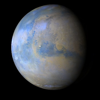
NASA’s Mars rover Curiosity is now selecting rock targets for its laser spectrometer — the first time autonomous target selection is available for an instrument of this kind on any robotic planetary mission.

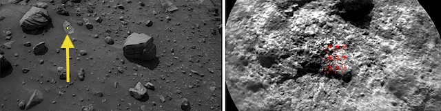
Using software developed at NASA’s Jet Propulsion Laboratory, Pasadena, California, Curiosity is now frequently choosing multiple targets per week for a laser and a telescopic camera that are parts of the rover’s Chemistry and Camera (ChemCam) instrument. Most ChemCam targets are still selected by scientists discussing rocks or soil seen in images the rover has sent to Earth, but the autonomous targeting adds a new capability. (…)

AEGIS software, for Autonomous Exploration for Gathering Increased Science, had previously been used on NASA’s Mars Exploration Rover Opportunity, though less frequently and for a different type of instrument. That rover uses the software to analyze images from a wide-angle camera as the basis for autonomously selecting rocks to photograph with a narrower-angle camera. Development work on AEGIS won a NASA Software of the Year Award in 2011.

“This autonomy is particularly useful at times when getting the science team in the loop is difficult or impossible — in the middle of a long drive, perhaps, or when the schedules of Earth, Mars and spacecraft activities lead to delays in sharing information between the planets,” said robotics engineer Tara Estlin, the leader of AEGIS development at JPL. [More at link]

Posted in Reports | Tagged , , , , , , , , | Comments Off

Curiosity update: Bimbe conglomerates

FLB_522309218EDR_F0560000FHAZ00341M_-br2Sol 1405-08, July 20, 2016, update from USGS scientist Ryan Anderson: After a busy weekend plan, we are back to “restricted” sols this week, planning two days at a time. Monday’s planning for sols 1405-1406 started off with a discussion of whether we wanted to do some brief contact science before driving, or just drive straight for the block deposit called “Bimbe”.

In the end, we decided to keep the contact science in the plan, so sol 1405 included some MAHLI imaging of the target “Guri”. Mastcam had a multispectral observation of Guri as well as “Galo” to look for evidence of hematite. Mastcam also had an observation of an outcrop of possible conglomerate rock. ChemCam had measurements of the bedrock targets “Cela” and “Dala”.

After that we drove toward Bimbe. On sol 1406, we had a Navcam atmospheric observation and a… [More at link]

Posted in Reports | Tagged , , , , , , , , , , , , , , , , , , , , , | Comments Off

THEMIS: Dunes in Juventae Chasma – false color

Dunes and ridges in Juventae Chasma (THEMIS_IOTD_20160721)THEMIS Image of the Day, July 21, 2016. Today’s false color image shows part of Juventae Chasma. Dunes are visible on the floor of the chasma. The THEMIS VIS camera contains 5 filters. The data from different filters can be combined in multiple ways to create a false color image. These false color images may reveal subtle variations of the surface not easily identified in a single band image.

More THEMIS Images of the Day by geological topic.

Posted in Reports | Tagged , , , , , , , , , | Comments Off

MARCI weather report, July 11-17, 2016

releaseimg_160711_160717A slight lull in southern hemisphere dust storm activity for the past week on Mars. A couple small transient dust storms were spotted over Cimmeria and Noachis. Focusing a bit further equatorward, dust haze, lifted from the previous week’s activity, lingered over Noachis, Sirenum, and Aonia. During that time, large arcuate-shaped dust storms propagated eastward over the northern plains from Acidalia to Utopia. Looking to… [More at link, including video]

Posted in Reports | Tagged , , , , , , , , , , , , , | Comments Off

HiRISE: Mesas and pits

ESP_045390_2215What’s up and what’s down? This image covers mesas, or high-standing plateaus, to the north and pits, or low-standing, depressions to the south. If it looks the other way around, then you are not seeing the topography correctly.

Remember that the Sun is coming from the left (west) at MRO’s imaging time of about 3 p.m. What formed these mesas and pits is a question that is not so easy to answer. [More at link]

Posted in Reports | Tagged , , , , , , , , | Comments Off

THEMIS: Graben in Nili Fossae

Nili Fossae (THEMIS_IOTD_20160720)THEMIS Image of the Day, July 20, 2016. Nili Fossae is a large band of parallel graben located to the northeast of Syrtis Major. The graben in this VIS image were formed by tectonic activity, with faulting that creates the linear depression.

More THEMIS Images of the Day by geological topic.

Posted in Reports | Tagged , , , , , , , , , | Comments Off

HiRISE: Slope instability

ESP_037700_1710One small section of this image shows boulders that have rolled down the slope of a crater wall. The boulders vary in size, with the largest one approximately 6 meters across. Unlike the boulder in a previous image, this one is not standing on end. We can tell by using the sun angle and shadow length to figure out the height and then comparing that to its other measurements.

We can determine the origin of the boulders by tracing their up-slope tracks. They appear to come from one small part of the crater wall that is less stable than surrounding materials. It is likely that there have been numerous… [More at link]

Posted in Reports | Tagged , , , , , , , | Comments Off

Opportunity: Down the valley

4438-navcamSol 4438, July 19, 2016. Three Navcam frames portray the slope of Marathon Valley, and assorted rocks near the rover. Hinners Point lies out of the frame to the left, Knudsen Ridge at right. Click to enlarge.

Opportunity raw images, its latest mission status, a location map. and atmospheric opacity, known as tau.

Posted in Reports | Tagged , , , , , , , , | Comments Off

HiRISE: Basal unit, north polar layered deposits

tumblr_oaj9qmboaJ1rlz4gso1_1280Basal unit of north polar layered deposits stratigraphy.

Beautiful Mars series.

Posted in Reports | Tagged , , , , , , , , | Comments Off

THEMIS: Channel between two craters

Channel between craters (THEMIS_IOTD_20160719)THEMIS Image of the Day, July 19, 2016. This VIS image shows a short section of channel between two craters in Terra Sabaea. One crater is outside the image area at the upper left of the image. The channel appears to stop in the center of the image, which is the location of the rim of the second crater.

More THEMIS Images of the Day by geological topic.

Posted in Reports | Tagged , , , , , , , , , | Comments Off