Curiosity update: ‘Arm error recovery’

1100ML0048710060500490E01_DXXX
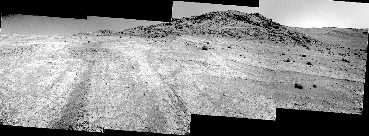
Sol 1102-1104, September 11, 2015, update from USGS scientist Ken Herkenhoff: The Sol 1101 activities that we planned yesterday did not complete due to an arm error while it was being stowed.  Apparently the shoulder azimuth motor was too cold, so the rover software halted the stow, which precluded the drive that was to follow.  The rover is therefore in the same position that it was yesterday.

I’m not scheduled in any operational role today, but I called in to help plan MAHLI imaging of the ChemCam optical window, to monitor dust accumulation.  The operations team had to scramble to recover from the arm error and plan science observations, but was able to put together an excellent weekend plan.  On Sol 1102, MAHLI will take the standard images of the rover wheels, then acquire a full suite of images of a rock dubbed “Badlands.” [More at link]

Posted in Reports | Tagged , , , , , , , , , , , , | Comments Off

Curiosity panorama shows petrified sand dunes

PIA19818_ipSome of the dark sandstone in an area being explored by NASA’s Curiosity Mars rover shows texture and inclined bedding structures characteristic of deposits that formed as sand dunes, then were cemented into rock. A panorama from Curiosity’s Mast Camera (Mastcam) that includes a ridge made of this sandstone is online [here].

This sandstone outcrop — part of a geological layer that Curiosity’s science team calls the Stimson unit — has a structure called crossbedding on a large scale that the team has interpreted as deposits of sand dunes formed by wind. Similar-looking petrified sand dunes are common in the U.S. Southwest. Geometry and orientation of the crossbedding give information about the directions of the winds that produced the dunes.

The Stimson unit overlies a layer of mudstone that was deposited in a lake environment. Curiosity has been examining successively higher and younger layers of Mount Sharp, starting with the mudstone at the mountain’s base, for evidence about changes in the area’s ancient environment. [More at links]

Posted in Reports | Tagged , , , , , , , , , , | Comments Off

Opportunity: Northwest wall, Marathon Valley

4134-navcamSol 4134, September 10, 2015. Four Navcam frames make a composite image of upper Marathon Valley and the rock outcrop forming the northwestern wall at the top of the valley. Click to enlarge.

Opportunity raw images, its latest mission status, a location map. and atmospheric opacity, known as tau.

Posted in Reports | Tagged , , , , , , | Comments Off

Curiosity update: ‘Driving into the saddle’

NLB_495148672EDR_F0492902NCAM00270M_Sol 1101, September 10, 2015, update from USGS scientist Ken Herkenhoff: The 34-meter drive planned for Sol 1100 placed the rover at the edge of the small plateau, as intended, with a good view of a bright Murray Formation outcrop.  The center of the Murray outcrop is the target of the drive planned for Sol 1101, which will hopefully put the vehicle in position for contact science over the weekend.  Before the drive, ChemCam RMI and Mastcam observations of targets named “Brady” and “Bradley” are planned, both of… [More at link]

Posted in Reports | Tagged , , , , , , , , , , , , | Comments Off

THEMIS: Deuteronilus Mensae – false color

Deuteronilus Mensae (THEMIS_IOTD_20150911)THEMIS Image of the Day, September 11, 2015. The THEMIS VIS camera contains 5 filters. The data from different filters can be combined in multiple ways to create a false color image. These false color images may reveal subtle variations of the surface not easily identified in a single band image. Today’s false color image shows one of the many mesas that make up Deuteronilus Mensae.

More THEMIS Images of the Day by geological topic.

Posted in Reports | Tagged , , , , , , , , , , | Comments Off

HiRISE: Pitted dunes in the Southern Highlands

tumblr_nqbl7blwXG1rlz4gso2_1280Pitted dunes in the Southern Highlands. Beautiful Mars series.

Posted in Reports | Tagged , , , , , , , , , | Comments Off

HRSC: Mars south pole and beyond

Mars_south_pole_and_beyondThis sweeping view by ESA’s Mars Express extends from the planet’s south polar ice cap and across its cratered highlands to the Hellas Basin (top left) and beyond…

The image was acquired by the high-resolution stereo camera on ESA’s Mars Express on 25 February 2015. It is a ‘broom calibration’ image, acquired while the spacecraft performed a manoeuvre such that its camera pans over the surface far above the planet, at about 9 900 km. [More at link]

Posted in Reports | Tagged , , , , , , , , , , | Comments Off

MAVEN: Deep-dip campaign #4 ends successfully

MVN-deep-dip4NASA’s MAVEN spacecraft, in orbit at Mars since Sept. 21, 2014, has completed the fourth deep-dip campaign of its primary science mission. The series of five-day campaigns are designed to lower the periapsis (lowest altitude) of the spacecraft above Mars in order to achieve a targeted atmospheric density corridor and to sample the lower, well-mixed portion of the Martian upper atmosphere. The density at 125 km (78 mi) can be 30 times that encountered during the nominal science orbits, where the periapsis is approximately 150 km (93 mi)… [More at link]

Posted in Reports | Tagged , , , | Comments Off

Curiosity update: ‘Swan, Sunburst, Studhorse, Sweetgrass Arch, and Silver Hill’

NLB_495061043EDR_F0492626NCAM00268M_Sol 1100, September 9, 2015, update from USGS scientist Ken Herkenhoff: The rover drove 34.5 meters on Sol 1099, as planned, to a good location for the imaging of the northwest wall of Bridger Basin.  The Mastcam team verified that the pointing of the mosaic of that wall, planned to occur early on Sol 1100, is excellent.  So the Sol 1100 plan includes another drive, to the southwest edge of the small plateau the rover is on.  Before the drive, ChemCam and Mastcam will observe nearby layered rocks dubbed “Swan” and “Sunburst,” and Right Mastcam mosaics… [More at link]

Posted in Reports | Tagged , , , , , , , , , , , , , , , , | Comments Off

HRSC: Atlantis Chaos flyover video

atlantis-flyover1Explore the Atlantis Chaos region of Mars, in the Red Planet’s southern hemisphere. The video showcases a myriad of features that reflect a rich geological history. The tour takes in rugged cliffs and impact craters, alongside parts of ancient shallow, eroded basins. See smooth plains scarred with wrinkled ridges, scarps and fracture lines that point to influence from tectonic activity. Marvel at ‘chaotic’ terrain – hundreds of small peaks and flat-topped hills that are thought to result from the slow erosion of a once-continuous solid plateau. This entire region may once have played host to vast volumes of water – look out for the evidence in the form of channels carved into steep-sided walls.

Also: HRSC mosaic image of the Atlantis Chaos region. [More at links]

Posted in Reports | Tagged , , , , , , , , , , | Comments Off