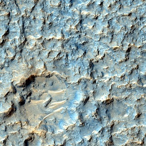
THEMIS: Coprates Chasma – false color

THEMIS Image of the DayRidges and gullies in Coprates Chasma (THEMIS_IOTD_20150910), September 10, 2015. The THEMIS VIS camera contains 5 filters. The data from different filters can be combined in multiple ways to create a false color image. These false color images may reveal subtle variations of the surface not easily identified in a single band image. Today’s false color image shows part of Coprates Chasma.

More THEMIS Images of the Day by geological topic.

Posted in Reports | Tagged , , , , , , , , , , | Comments Off

HiRISE: Rocky crater floor

tumblr_ntm1po3yDp1rlz4gso1_1280Rocky crater floor. Very rocky, indeed. The crater itself is huge, much larger than what we can see with HiRISE.

Beautiful Mars series.

Posted in Reports | Tagged , , , , , , , , | Comments Off

Curiosity: Bypassing Bob Marshall Ridge

1099-bob_marshall-brSol 1099, September 9, 2015. As Curiosity advances into Bridger Basin, it is driving past a low rise, dubbed Bob Marshall Ridge, which lies to the right of the rover’s path. The ridge has multiple layers within it; the hills in the distance are part of Gale Crater’s northern rim. Click image to download larger version (1.4 MB file).

Sol 1099 raw images (from all cameras), and Curiosity’s latest location map.

Posted in Reports | Tagged , , , , , , , , | Comments Off

HiRISE: Not our planet

tumblr_ntm0nswCNb1rlz4gso1_1280Not our planet. Beautiful Mars series.

Posted in Reports | Tagged , , , , , , , , | Comments Off

MARCI weather report, Aug 31-Sept 6, 2015

releaseimg_150831_150906For the past week on Mars, condensate water-ice clouds and dust storms continued to propagate eastward along the seasonal north polar ice cap edge. Further south, in the equatorial latitudes, diffuse water-ice clouds were spotted over Tempe, Alba Patera, Elysium, Syrtis, Eastern Meridiani, and the Tharsis volcanoes. Meanwhile… [More at link, including video]

Posted in Reports | Tagged , , , , , , , , , , , , | Comments Off

Opportunity: Late afternoon, looking east

4132-navcamSol 4132, September 8, 2015. With Opportunity parked at the Pvt. Silas Goodrich outcrop, the Navcam shot a late-afternoon view to the east. Marathon Valley slopes downward toward the dune-strewn floor of Endeavour Crater, while the far rim cuts the horizon, some 22 kilometers (14 miles) away. Click to enlarge.

Opportunity raw images, its latest mission status, a location map. and atmospheric opacity, known as tau.

Posted in Reports | Tagged , , , , , , , | Comments Off

THEMIS: Aureum Chaos – false color

Mesas and valleys in Aureum Chaos (THEMIS_IOTD_20150909)THEMIS Image of the Day, September 9, 2015. The THEMIS VIS camera contains 5 filters. The data from different filters can be combined in multiple ways to create a false color image. These false color images may reveal subtle variations of the surface not easily identified in a single band image. Today’s false color image shows part of Aureum Chaos.

More THEMIS Images of the Day by geological topic.

Posted in Reports | Tagged , , , , , , , , , , | Comments Off

Curiosity update: ‘Driving again’

NRB_494970866EDR_F0492374NCAM00266M_Sol 1099, September 8, 2015, update from USGS scientist Ken Herkenhoff: MSL did well over the long weekend, except that the Sol 1098 drive was halted after 13 meters of the planned 25 meters because the rover could not confirm that the path ahead was safe.  So the plan for the Sol 1099 drive is essentially to complete the rest of the previously planned drive.  The only significant problem I’ve had to grapple with today as SOWG Chair is that the last 5 relays of data through MRO have returned significantly less data than expected; if this problem continues, we will barely receive enough data to plan another drive on Sol 1100.  Fortunately… [More at link]

Posted in Reports | Tagged , , , , , , , , , , , , | Comments Off

Curiosity: Bridger Basin just ahead ahead

1098-navcamSol 1098, September 8, 2015. The Navcam shoots the landscape in front of Curiosity — and it’s rocky dead ahead, then smoother into Bridger Basin. The dark rise at right in the middle distance is Bob Marshall Ridge. Farther away, Mount Sharp’s lowest slopes lie at left (mostly cut off) and the southwestern Gale rim is faintly visible in the distance at right. Click to enlarge.

Sol 1098 raw images (from all cameras), and Curiosity’s latest location map.

Posted in Reports | Tagged , , , , , , , , | Comments Off

Opportunity: Pebbles and dust at Silas Goodrich

1F494927263EFFCO97P1110L0M1Sol 4131, September 7, 2015. Below is a three-frame composite of Microscopic Imager shots looking at small rocks and dirt at the Pvt. Silas Goodrich outcrop. At right is the Hazcam view, taken in late afternoon. (Click either image to enlarge.)

Opportunity raw images, its latest mission status, a location map. and atmospheric opacity, known as tau.


Posted in Reports | Tagged , , , , , , , | Comments Off