Mars 2020: Landing sites, old and new, ranked at 2nd workshop for NASA’s next rover mission

marsnext_imageDesigned to study rocks and soils to understand past habitable conditions on Mars and to seek signs of ancient microbial life, NASA’s Mars 2020 rover still has no formal name, but the work of selecting its landing site continues apace.

Scientists recently met for a second time to propose and evaluate potential landing sites. The second landing site workshop was held in Monrovia, California, August 4-6, 2015, with 150 to 200 scientists participating onsite and remotely. (The first workshop was in May 2014.)

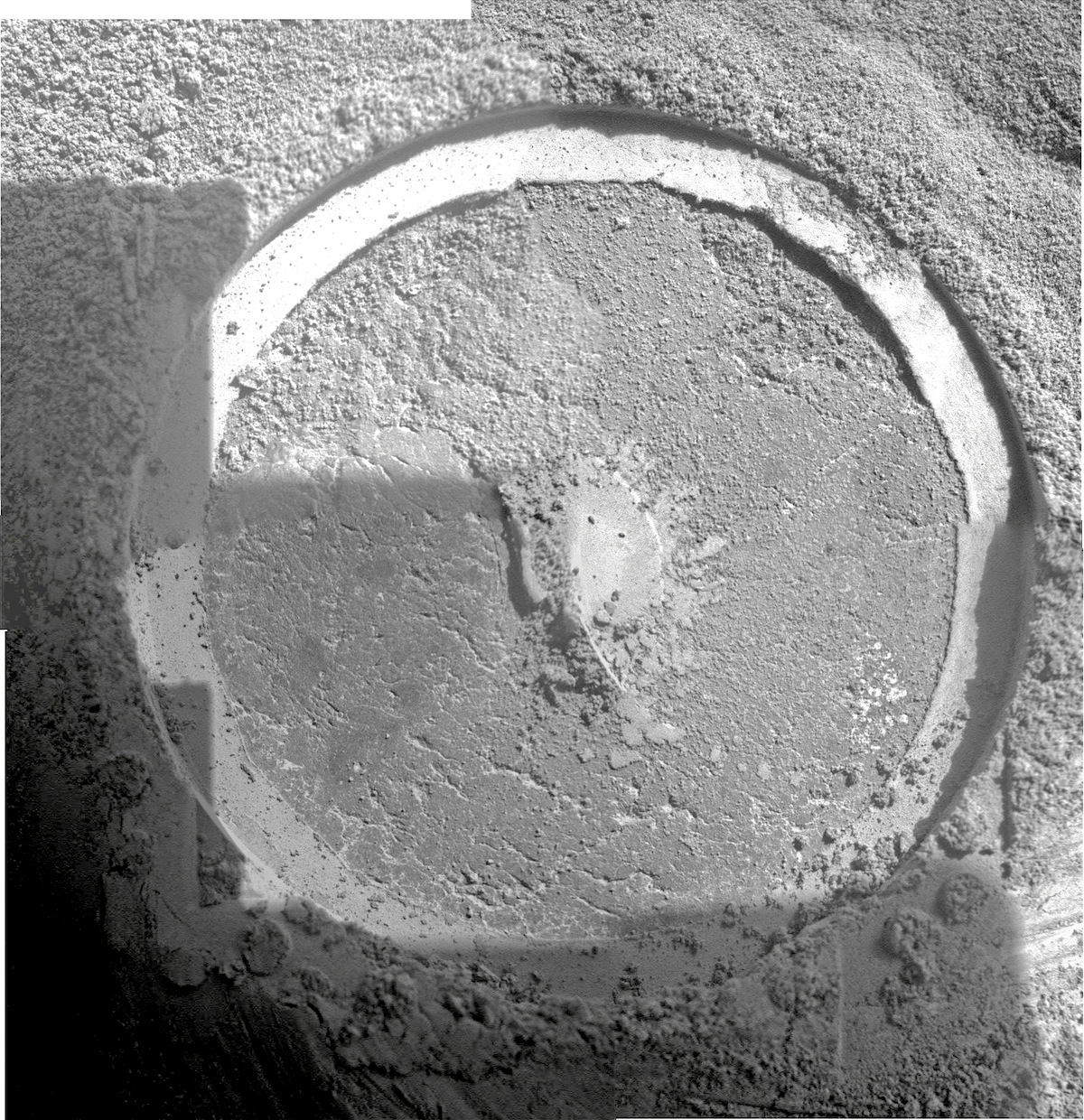
The top 10 sites (out of 21 proposed) as ranked by the meeting participants on scientific grounds were: Jezero Crater (18.5°N, 77.4°E), Columbia Hills (Gusev Crater, 14.4°S, 175.6°E), NE Syrtis Major (17.8°N, 77.1°E), Eberswalde Crater (23.0°S, 327.0°E), SW Melas Basin (12.2°S, 290.0°E), Nili Fossae Trough North (21.0°N, 74.5°E), Nili Fossae Carbonate (21.9°N, 74.5°E), Mawrth Vallis (24.0°N, 341.1°E), Holden Crater (26.4°S, 325.1°E), and McLaughlin Crater (21.9°N, 337.8°E).

Most of these sites were proposed for the 2012 Mars Science Laboratory (Curiosity) mission, and one — the Columbia Hills of Gusev Crater — has been reconnoitered by the Mars Exploration Rover Spirit, which found hot-spring deposits there.

Along with science rankings, the Mars 2020 Rover Project also examined engineering, operations, and other factors. In addition, the project wished to reduce the number of candidate sites. When sifted through these filters, eight sites remained. In alphabetical order, they are: Columbia Hills/Gusev, Eberswalde, Holden, Jezero, Mawrth, NE Syrtis, Nili Fossae, and SW Melas. (In the final sorting, the Nili Fossae Carbonate site, which scored #7 on science, was deleted due to high engineering risk and science overlap with other sites. Holden moved up in its place.)

For the locations of the eight landing sites, see the Mars map above; for the rankings of all 21 sites according to their scientific criteria, see the chart below. Click either image to enlarge.

Mars 2020 is set for launch in July-August 2020, arriving in February 2021. The rover’s baseline mission will last one Mars year, or 1.9 Earth years. The engineering criteria for what makes a site feasible are here and the mission’s geological criteria and goals are here.

2WS_landing-sites_rated

Posted in Reports | Tagged , , , | Comments Off

Curiosity update: ‘Lots of MAHLI targets’

1089MH0001930000400840R00_DXXXSol 1091, August 31, 2015, update from USGS scientist Ken Herkenhoff: Planning is no longer restricted, but we had to start at 6:00 PDT this morning to give the operations team enough time to uplink commands by the time the rover expects them.  Driving to work before sunrise reminded me of the sometimes odd times we had to wake up during the first 90 sols of the mission, when the entire operations team was on “Mars time.”

The team is very interested in the outcrop in front of the rover, so I had a very busy day as MAHLI/MARDI uplink lead today, even though we are planning… [More at link]

Posted in Reports | Tagged , , , , , , , | Comments Off

THEMIS: Mamers Valles

Mamers Valles (THEMIS_IOTD_20150901)THEMIS Image of the Day, September 1, 2015. Today’s VIS image shows the start of Mamers Valles.

More THEMIS Images of the Day by geological topic.

Posted in Reports | Tagged , , , , , , , , | Comments Off

THEMIS: Nili Fossae

Nili Fossae (THEMIS_IOTD_20150831)THEMIS Image of the Day, August 31, 2015. The linear depression in today’s VIS image is part of Nili Fossae.

More THEMIS Images of the Day by geological topic.

Posted in Reports | Tagged , , , , , , , , , , | Comments Off

Curiosity update: ‘Stimson is stunning’

1085ML0047660020206932E01_DXXXSol 1089-1090, August 28, 2015, update from USGS scientist Lauren Edgar: Curiosity is currently making her way through some beautiful exposures of the Stimson unit.  The 6 m drive on Sol 1087 went well, and Curiosity is in a good position for possible contact science early next week.

Today we’re planning 2-sols for the weekend (Sunday is a “soliday” to allow Earth and Mars schedules to sync back up).  One of the main activities on Sol 1089 is dropping off part of the Buckskin drill sample to SAM.  Then we’ll dump the Buckskin post-sieve sample, and analyze it with APXS.  The plan also includes Mastcam and MAHLI imaging to document the dump pile. [More at link]

Posted in Reports | Tagged , , , , , , , , | Comments Off

Curiosity: Loomings

1087-aeolis-monsSol 1087, August 28, 2015. Mount Sharp rises above a low rocky ridge lying near the rover in a four-frame Navcam composite. The rocks of the ridge look like cross-bedded sandstones. Click to enlarge.

Sol 1087 raw images (from all cameras), and Curiosity’s latest location map.

Posted in Reports | Tagged , , , , , , | Comments Off

THEMIS: Galaxias Fossae

Rifts of Galaxias Fossae (THEMIS_IOTD_20150828)THEMIS Image of the Day, August 28, 2015. The linear depression in today’s VIS image is part of Galaxias Fossae.

More THEMIS Images of the Day by geological topic.

Posted in Reports | Tagged , , , , , , , , | Comments Off

HiRISE: With enough time, the sand will devour all

tumblr_ntkki6W4lp1rlz4gso1_1280With enough time, the sand will devour all. Sand dunes are among the most widespread wind-driven features present on Mars.

Beautiful Mars series.

Posted in Reports | Tagged , , , , , , , , , , | Comments Off

Opportunity: MI on Pvt. Robert Frazer6

4120-MISol 4120, August 27, 2015. After the Rock Abrasion Tool (RAT) removed the surface layer on Pvt. Robert Frazer6, Opportunity’s Microscopic Imager moved in for a close-up view. The image at right is a four-frame composite. Click to enlarge.

Pvt. Robert Frazer is the name of an outcrop on Marathon Valley’s floor. Each separate target on the outcrop receives a sequential ID number, hence Pvt. Robert Frazer6.

Opportunity raw images, its latest mission status, a location map. and atmospheric opacity, known as tau.

Posted in Reports | Tagged , , , , , , , , | Comments Off

Terraced craters point to subsurface ice sheets

21jyoow_0Just beneath the planet’s dirt surface, University of Arizona researchers found an enormous slab of water ice, measuring 130 feet thick and covering an area equivalent to that of California and Texas combined.

It was a “crazy-looking crater” on the face of Mars that caught Ali Bramson’s eye. But it was a simple calculation that explained the crater’s strange shape. Combining data gleaned from two powerful instruments aboard NASA’s Mars Reconnaissance Orbiter, or MRO, Bramson and her colleagues determined why the crater is terraced — not bowl shaped, like most craters of this size.

“Craters should be bowl shaped, but this one had terraces in the wall,” says Bramson, a graduate student in the University of Arizona’s Lunar and Planetary Laboratory, or LPL.

[The research was published online in the journal Geophysical Research Letters.]

“When the crater is forming, the shock wave from an object hitting a planet’s surface propagates differently depending on what substrates are beneath the area of impact,” Bramson says. “If you have a weaker material in one layer, the shock wave can push out that material more easily, and the result is terracing at the interface between the weaker and stronger materials.” [More at links]

bramson-terraced-craters

Posted in Reports | Tagged , , , , , , , , , , , | Comments Off