


-
Recent Posts
Archives
Links
general
mission instruments
- CRISM: Compact Reconnaissance Imaging Spectrometer for Mars
- CTX: Context Camera
- HiRISE: High Resolution Imaging Science Experiment
- MARSIS: Mars Advanced Radar for Subsurface and Ionosphere Sounding
- SHARAD: Shallow Radar
- THEMIS: Thermal Emission Imaging System
missions
- All Mars missions list
- Curiosity rover
- ExoMars
- Hope (al-Amal) orbiter
- InSight
- Mars Atmosphere and Volatile Evolution Mission (MAVEN)
- Mars Exploration Rovers (MER)
- Mars Express (MEX)
- Mars Odyssey
- Mars Orbiter Mission (MOM) / Mangalyaan
- Mars Reconnaissance Orbiter (MRO)
- Mars Science Laboratory (MSL)
- Perseverance Rover
- Tianwen-1 orbiter/rover
news
HiRISE: Ridges in Gordii Dorsum
Posted in Reports
Tagged Beautiful Mars, Gordii Dorsum, High Resolution Imaging Science Experiment, HiRISE, Mars Reconnaissance Orbiter, MRO, NASA, University of Arizona, yardangs
Comments Off
THEMIS: Candor Chasma – false color
 THEMIS Image of the Day, August 11, 2015. The THEMIS VIS camera contains 5 filters. The data from different filters can be combined in multiple ways to create a false color image. These false color images may reveal subtle variations of the surface not easily identified in a single band image. Today’s false color image shows part of Candor Chasma.
More THEMIS Images of the Day by geological topic.
Posted in Reports
Tagged Arizona State University, ASU, Candor Chasma, color, interior layered deposits, layers, Mars Odyssey, NASA, sediments, THEMIS, Thermal Emission Imaging System, Valles Marineris
Comments Off
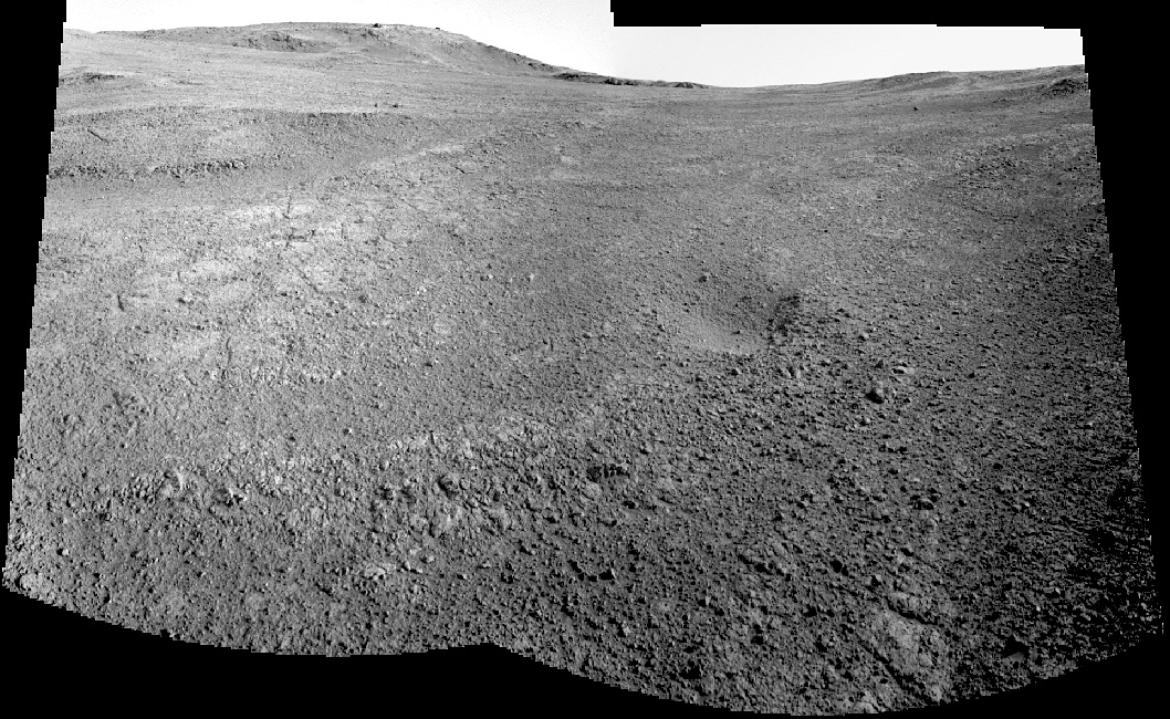
Opportunity: Look down, look up
 Sols 4102-4103, August 9-10, 2015. On Sol 4102, the rover’s Navcam shot a three-frame composite looking down the slope of Marathon Valley (above). Then on the next day, it took a pair of images looking back upslope (below). The ridge on the left skyline in the view below is dubbed Corinth. (Click to enlarge.)
Opportunity raw images, its latest mission status, a location map. and atmospheric opacity, known as tau.
Posted in Reports
Tagged Cape Tribulation, Corinth, Endeavour Crater, Marathon Valley, Mars Exploration Rover, MER, NASA, Opportunity
Comments Off
MRO: Going strong, 10 years after launch
 Ten years after launch, NASA’s Mars Reconnaissance Orbiter (MRO) has revealed the Red Planet’s diversity and activity, returning more data about Mars every week than all six other missions currently active there. And its work is far from over.
The workhorse orbiter now plays a key role in NASA’s Journey to Mars planning. Images from the orbiter, revealing details as small as a desk, aid the analysis of potential landing sites for the 2016 InSight lander and Mars 2020 rover. Data from the orbiter will also be used as part of NASA’s newly announced process to examine and select candidate sites where humans will first explore the Martian surface in the 2030s.
An Atlas V rocket launched the orbiter on an early Florida morning from Cape Canaveral Air Force Station on Aug. 12, 2005, propelling it on a course toward Mars. [More at link]
Mars Orbiter Mission: AO for data from MCC, TIS, MSM, LAP, and MENCA instruments
 Indian Space Research Organization (ISRO), Department of Space (DOS), Government of India, announces an opportunity (AO) to carry out scientific research using data from Mars Orbiter Mission (MOM). MOM is ISRO’s first interplanetary space probe dedicated for the Mars research.
This AO is targeted towards utilizing the data from five payloads of MOM, namely Mars Colour Camera (MCC), Thermal Infrared Imaging Spectrometer (TIS), Methane Sensor for Mars (MSM), Lyman Alpha Photometer (LAP) and Mars Exospheric Neutral Composition Analyser (MENCA). MOM was launched from Sriharikota, India using a Polar Satellite Launch Vehicle (PSLV) rocket on 5th November 2013. The science objectives include exploration of the surface of Mars and its atmosphere. This requires observations on geologic and atmospheric processes acting on Mars. Considering these requirements, the above five scientific payloads have been flown onboard MOM. [More at link]
Posted in Reports
Tagged Indian Space Research Organization, ISRO, LAP, Lyman Alpha Photometer, Mars Color Camera, Mars Exospheric Neutral Composition Analyser, Mars Orbiter Mission, MCC, MENCA, Methane Sensor for Mars, MOM, MSM, Thermal Infrared Imaging Spectrometer, TIS
Comments Off
THEMIS: Hesperia Planum – false color
 THEMIS Image of the Day, August 10, 2015. The THEMIS VIS camera contains 5 filters. The data from different filters can be combined in multiple ways to create a false color image. These false color images may reveal subtle variations of the surface not easily identified in a single band image. Today’s false color image shows the rim and ejecta of an unnamed crater on the northwest margin of Hesperia Planum.
More THEMIS Images of the Day by geological topic.
Posted in Reports
Tagged Arizona State University, ASU, color, craters, ejecta, Hesperia Planum, Mars Odyssey, NASA, THEMIS, Thermal Emission Imaging System
Comments Off
Salt flat: a last vestige of Mars surface water?
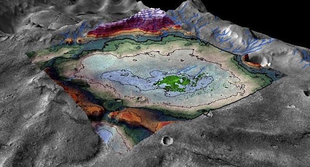 Mars turned cold and dry long ago, but researchers at the University of Colorado Boulder have discovered evidence of an ancient lake that likely represents some of the last potentially habitable surface water ever to exist on the Red Planet.
The study, published Thursday in the journal Geology, examined an 18-square-mile chloride salt deposit (roughly the size of the city of Boulder) in the planet’s Meridiani region near the Mars Opportunity rover’s landing site. As seen on Earth in locations such as Utah’s Bonneville Salt Flats, large-scale salt deposits are considered to be evidence of evaporated bodies of water.
Digital terrain mapping and mineralogical analysis of the features surrounding the deposit indicate that this one-time lakebed is no older than 3.6 billion years old, well after the time period when Mars is thought to have been warm enough to sustain large amounts of surface water planet-wide. Planetary scientists believe that the solar system formed approximately 4.6 billion years ago.
“This was a long-lived lake, and we were able to put a very good time boundary on its maximum age,” said Brian Hynek, a research associate at the Laboratory for Atmospheric and Space Physics (LASP) at CU-Boulder and lead author of the study. “We can be pretty certain that this is one of the last instances of a sizeable lake on Mars.” [More at links]
Curiosity update: ‘Back at Missoula’
 Sol 1068-1070, August 7, 2015, update from USGS scientist Lauren Edgar: Curiosity had a successful drive of 19 m on Sol 1067, and we are currently back at Missoula for more targeted science. The goal is to perform a detailed study of the Stimson-Pahrump contact, and to determine the relative timing of some of the veins that we’ve observed here.
The three-sol plan is a busy one, with a lot of ChemCam analyses. On Sol 1068 Curiosity will acquire ChemCam LIBS on four different “Missoula” targets (Missoula A, B, C, and D), to understand the chemistry across the contact. We’ll also acquire several Mastcam images to document those targets. On Sol 1070, we’ll acquire a ChemCam passive observation on the target “Coombs” (“passive” means that we don’t fire the laser, we just passively collect the spectrum of the target), and a regular ChemCam LIBS observation on the target “Stenerson.” [More at link]
Posted in Reports
Tagged Aeolis Mons, Apikuni Mountain, Coombs, Curiosity, Gale Crater, Marias Pass, Mars Science Laboratory, Missoula, Mount Sharp, MSL, NASA, Pahrump Hills, Stenerson, Stimson Formation
Comments Off
THEMIS: Terra Sabaea — false color
 THEMIS Image of the Day, August 7, 2015. The THEMIS VIS camera contains 5 filters. The data from different filters can be combined in multiple ways to create a false color image. These false color images may reveal subtle variations of the surface not easily identified in a single band image. Today’s false color image shows part of the plains of Terra Sabaea.
More THEMIS Images of the Day by geological topic.
Posted in Reports
Tagged Arizona State University, ASU, color, Mars Odyssey, NASA, Terra Sabaea, THEMIS, Thermal Emission Imaging System
Comments Off
Curiosity update: ‘Bumping to Missoula… sound familiar?’
 Sol 1067, August 6, 2015, update from USGS scientist Lauren Edgar: With a familiar blog title, I report that in today’s plan we’re bumping towards the Missoula outcrop. On Sol 1066 Curiosity drove ~ 25 m back toward Missoula, but we still have a little further to go. However, the science team took advantage of our current position to collect some additional data on the Stimson unit (shown in the Navcam image [at right]).
Today’s plan includes ChemCam and Mastcam observations of the targets “Dixon” and “Doney” to assess the chemistry in different parts of the Stimson unit. We’ll also acquire a Mastcam mosaic to characterize the terrain that DAN sampled. Then Curiosity will… [More at link]
Posted in Reports
Tagged Aeolis Mons, Apikuni Mountain, Curiosity, Dixon, Doney, Gale Crater, Marias Pass, Mars Science Laboratory, Missoula, Mount Sharp, MSL, NASA, Stimson Formation
Comments Off