THEMIS Image of the Day, March 11, 2019. Today’s VIS image shows part of the dune field on the floor and within the pits of Rabe Crater. This crater, and a handful of others in Noachis Terra, have unique floors.
At some point after the initial formation of the crater there was an influx of fill material. The later erosion of this material formed a series of large, deep pits in the crater floor.
The continued erosion of the floor fill as well as the influx of wind driven sand and dust particles provided the raw materials for the formation of the dunes. The prevailing winds blow from the lower right to the upper left of the image.
An international team of researchers, which includes scientists from McMaster’s School of Geography & Earth Sciences, NASA, and others, is tackling one of the biggest problems of space travel to Mars: what happens when we get there?
A series of articles published today [March 7] in a special edition of the journal Astrobiology, focuses on the scientific, logistical, operational and communications challenges of sending astronauts to deep space.
It is the culmination of years of work in NASA’s BASALT research program, or the Biologic Analog Science Associated with Lava Terrains, which involves geologists, microbiologists, geneticists, engineers and astrobiologists from all over the world. (…)
Researchers simulated mission conditions on Mars in several scenarios which included conducting field work in the unforgiving, Mars-like terrain of Craters of the Moon National Park Monument and Preserve in Idaho and the Hawaii Volcanoes National Park.
These regions are rich in basalt, a fine-grained rock similar to rock found on Mars. Scientists hope samples can provide important clues in the ongoing search for life on Mars.
Supported by funding from the Canadian Space Agency, Allyson Brady, a postdoctoral fellow in McMaster’s School of Geography & Earth Sciences, who is working with her advisor Greg Slater on the project, is investigating organic biomarkers of microbial life associated with the rocks.
“When astronauts finally go to Mars, we need to identify the best place to potentially find evidence of life and to target the kind of basalt rock samples which may contain a lot of organic material, for example,” explains Brady. “There will be many, many limitations on Mars so we need to consider the best way to conduct research and gather samples including getting timely feedback from science experts on Earth.” [More at links]
• We report on properties of new dated crater clusters on Mars; most clusters in this study comprise <10 craters and span hundreds of meters
• Crater cluster dispersion increases for lower elevations when highest elevations are disregarded; impact azimuths are randomly distributed
• Impact angles are shallower than expected, which could be a possible observation effect
We studied clusters of new craters that formed in the last few years when meteoroids broke up in the atmosphere of Mars. We studied 77 clusters and measured the number of craters, the sizes of the clusters, how spread out the clusters are, the direction the impactors came from, and the angle of the impacts.
Clusters range from a few to hundreds of craters, with most containing tens of craters. They are usually spread out over hundreds of meters, ranging from a few meters to a few kilometers. Except for the highest areas, clusters are more spread out at lower elevations, as expected.
Impactors come from all different directions. Impacts are closer to horizontal than expected.
This information will be used to understand breakup in the Martian atmosphere; properties of the incoming meteoroids, such as their density and orbits; and how well we would be able to detect impacts with a seismometer. This is important because about half of current impacts at Mars are clusters. [More at link]
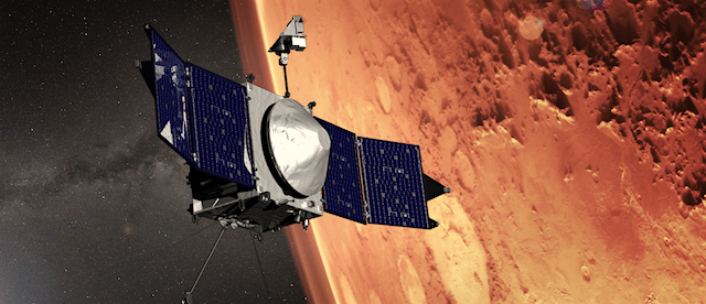
The MAVEN spacecraft today [March 7] performed an aerobraking maneuver (with a 0.2 m/s ∆V) to decrease the periapsis, or lowest, altitude by 1.2 km. MAVEN’s periapsis altitude is now 125.5 km above the surface of Mars and the apoapsis, or highest, altitude is 5,400 km. The density of the Martian atmosphere at periapsis is 3.4 kg/km³.
With today’s maneuver, the MAVEN aerobraking campaign continues to follow a schedule that will meet the goal of reaching an apoapsis altitude of 4,500 km by the end of April. [More at link]
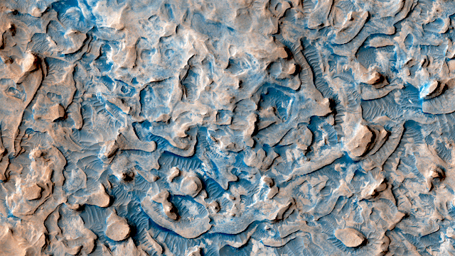
Layers in Meridiani. Despite the numerous data gaps with this observation, we can still get a closer look at the layers in Meridiani Planum. The hematite we find in this region is part of a layered sedimentary rock formation about 200 to 800 meters thick. The “blue” sand is basalt.
There are regions of small dunes towards the top and the bottom of the image. The wide range of colors indicate the complexity of surface materials in this area.
The THEMIS VIS camera contains 5 filters. The data from different filters can be combined in multiple ways to create a false color image. These false color images may reveal subtle variations of the surface not easily identified in a single band image.
Returning samples from the surface of Mars has been a high-priority goal of the international Mars exploration community for many years. Although randomly collected samples would be potentially interesting, they would not be sufficient to answer the big questions that have motivated Mars exploration for decades.
A new 150-page paper published in Meteoritics & Planetary Science describes the results of a major collaboration among 71 scientists from throughout the international science community to define specific scientific objectives for a Mars Sample Return campaign, to describe the critical measurements that would need to be done on returned samples to address the objectives, and to identify the kinds of samples that would be most likely to carry the key information. (…)
“This report establishes critical planning that will allow us to maximize the scientific value of the Mars samples should they be delivered to Earth,” said lead author Dr. David Beaty, of NASA’s Mars Program Office at JPL. “Science is working hand-in-hand with our amazingly talented colleagues in engineering to make MSR a reality.” [More at links]
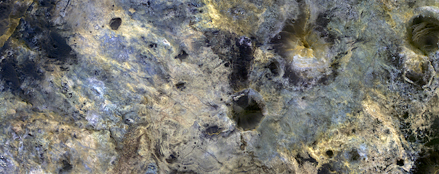
In this image, the enhanced black colors are most likely basaltic sands and rocks, while the green, yellow, and blue colors correspond to the different hydrated minerals.
This particular image was taken of a location in Mawrth Vallis that has a mineral called jarosite. Jarosite on Earth forms under wet, oxidizing, and acidic conditions. Another place on Mars where the Opportunity rover landed and explored also has jarosite. [More at link]
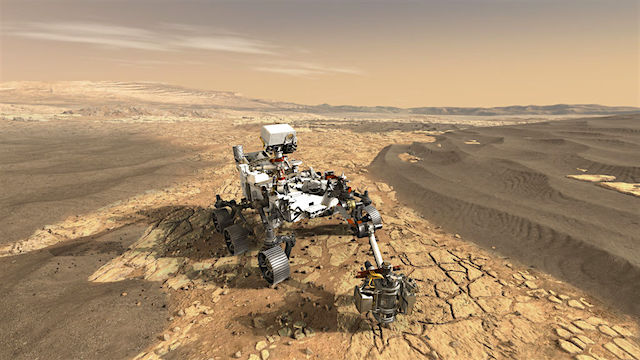
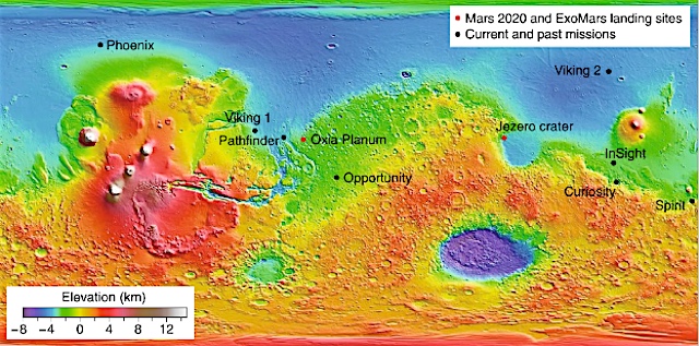
Engineers are assembling two ambitious rover missions for launch in 2020. Both seek to drill into Mars’s ancient sedimentary rocks in the hopes of finding evidence that life once thrived there.
But they have contrasting approaches to analysing the drilled samples. ESA’s ExoMars rover (recently named after DNA pioneer Rosalind Franklin) plans to study them in situ; NASA’s Mars 2020 rover will collect and document a set of samples for later return to Earth.
Both missions seek to understand the environmental conditions that prevailed when Mars was young, only about half a billion years after planetary formation. At the time, the atmospheres of both planets were dominated by carbon dioxide, and both enjoyed fluvial activity. On Earth, microbial life arose under those conditions. Did the same happen on Mars? [More at link]
THEMIS Image of the Day, March 7, 2019. This false-color VIS image shows part of the southern cliff face of Ius Chasma, part of the giant Valles Marineris rift system.
The THEMIS VIS camera contains 5 filters. The data from different filters can be combined in multiple ways to create a false color image. These false color images may reveal subtle variations of the surface not easily identified in a single band image.


 THEMIS Image of the Day, March 11, 2019. Today’s VIS image shows part of the dune field on the floor and within the pits of Rabe Crater. This crater, and a handful of others in Noachis Terra, have unique floors.