


-
Recent Posts
Archives
Links
general
mission instruments
- CRISM: Compact Reconnaissance Imaging Spectrometer for Mars
- CTX: Context Camera
- HiRISE: High Resolution Imaging Science Experiment
- MARSIS: Mars Advanced Radar for Subsurface and Ionosphere Sounding
- SHARAD: Shallow Radar
- THEMIS: Thermal Emission Imaging System
missions
- All Mars missions list
- Curiosity rover
- ExoMars
- Hope (al-Amal) orbiter
- InSight
- Mars Atmosphere and Volatile Evolution Mission (MAVEN)
- Mars Exploration Rovers (MER)
- Mars Express (MEX)
- Mars Odyssey
- Mars Orbiter Mission (MOM) / Mangalyaan
- Mars Reconnaissance Orbiter (MRO)
- Mars Science Laboratory (MSL)
- Perseverance Rover
- Tianwen-1 orbiter/rover
news
Opportunity: Hazcam tour of Meridiani Planum, Sols 1-5104
Posted in Reports
Tagged Cape Byron, Cape Tribulation, Eagle Crater, Endeavour Crater, Endurance Crater, Mars Exploration Rover, MER, Meridiani Planum, NASA, Opportunity, Perseverance Valley, Victoria Crater
Comments Off
HiRISE: Plains with diverse lithologies
 Plains with diverse lithologies. This observation was a “nadir” target, meaning our camera was pointing straight down at the surface. These pockmarked plains outside of a larger impact crater show some very nice colors. The top cutout is from our red-green-blue filter, and the bottom uses the infrared-red-blue filter. Both are less than 1 km across.
HiRISE Picture of the Day archive [More at links]
Posted in Reports
Tagged Aonia Terra, High Resolution Imaging Science Experiment, HiPOD, HiRISE, HiRISE Picture of the Day, Mars Reconnaissance Orbiter, MRO, NASA, plains, University of Arizona
Comments Off
THEMIS: Kaiser Crater dunes
 THEMIS Image of the Day, February 15, 2019. This VIS image is located in Kaiser Crater and shows several individual dunes. These dunes’ dark tone suggests they are free of dust, hence active.
With continued winds sand dunes will move across the surface. There are two sides to a dune, the low angle slope of the windward face and the high angle slope of the leeward side.
The steep side is called the slip face. Wind blows sand grains up the low angle slope of the dunes which then “fall down” the slip face. In this way the whole dune moves towards the slip face.
The winds blow from the windward to the leeward side of the dunes. In this image the slip faces are on the left side of the dune, so the dunes are slowly moving to the right side of this image.
Posted in Reports
Tagged active dunes, Arizona State University, ASU, dunes, Kaiser Crater, Mars Odyssey, NASA, sand dunes, THEMIS, THEMIS Image of the Day, Thermal Emission Imaging System
Comments Off
Weather at Gale Crater
Posted in Reports
Tagged Curiosity, dust storms, Gale Crater, global dust storms, Mars Science Laboratory, MSL, NASA, temperature, weather
Comments Off
Six things to know about Opportunity
 on NASA's Mars Exploration Rover Opportunity looks back toward part of the west rim of Endeavour Crater that the rover drove along, heading southward, during the summer of 2014. The vista merges multiple Pancam exposures taken on August 15, 2014, during the 3,754th Martian day, or sol, of Opportunity's work on Mars.") After 15 years, the mission of NASA’s Opportunity rover has come to an end, but its successes on Mars have earned it a spot in the robot hall of fame. Here’s what you need to know about our intrepid Martian overachiever:
After 15 years, the mission of NASA’s Opportunity rover has come to an end, but its successes on Mars have earned it a spot in the robot hall of fame. Here’s what you need to know about our intrepid Martian overachiever:
1. Opportunity was a twin.
The Mars Exploration Rovers mission featured two identical, golf-cart-sized, solar-powered rovers: Spirit and Opportunity. Spirit landed at Gusev Crater on Jan. 4, 2004. Opportunity landed on the opposite side of Mars at Meridiani Planum on Jan. 24, 2004 PST (Jan. 25 EST). Both rovers were managed for NASA by NASA’s Jet Propulsion Laboratory in Pasadena, California.
2. Opportunity and Spirit showed that Mars had the wet and warm conditions in its ancient past that were potentially hospitable to life.
Foremost among Spirit and Opportunity’s many science discoveries: Mars was likely wetter and warmer in the past. These conditions could have served as a cradle for life on Mars at a time when life first emerged on Earth.
Opportunity contributed several key findings to this conclusion. It was the first rover to identify and characterize sedimentary rocks on a planet other than Earth. Opportunity’s measurements showed these rocks formed in ancient ephemeral playas. Opportunity also discovered small spheres of hematite nicknamed “blueberries” that formed late from rising, acidic groundwater.
Once Opportunity reached the rim of Endeavour crater, the rover found white veins of the mineral gypsum – a telltale sign of water that traveled through underground fractures. Opportunity also found more compelling signs of Mars’ watery past in the rocks of Endeavour Crater: clay minerals that formed in neutral-pH (not too acidic, not too basic) water. Of all the places studied by Opportunity, the environment at Endeavour had the friendliest conditions for ancient microbial life… [More at link]
Posted in Reports
Tagged Cape Byron, Endeavour Crater, Mars Exploration Rover, MER, NASA, Opportunity, Perseverance Valley
Comments Off
HiRISE: Layered sedimentary rocks in Meridiani Planum
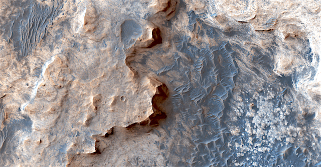 Layered sedimentary rocks in Meridiani Planum. Ah, the loveliness of Meridiani. Meridiani Planum is a plain located south of Mars’ equator, in the westernmost portion of Terra Meridiani. It hosts a rare occurrence of gray crystalline hematite, which on Earth, often forms in hot springs or in standing pools of water. Hmmm….
HiRISE Picture of the Day archive [More at links]
Posted in Reports
Tagged hematite, High Resolution Imaging Science Experiment, HiPOD, HiRISE, HiRISE Picture of the Day, Mars Reconnaissance Orbiter, Meridiani Planum, MRO, NASA, sedimentary deposits, University of Arizona
Comments Off
Opportunity report, Sol 5353, by A.J.S. Rayl, The Planetary Society
 that forced her to shut down and go into a kind of hibernation in June 2018. The MER team sent its final “Hail Mary’s” or last-ditch commands to try and re-establish contact with her on Feb. 12, 2019. But that was not to be and NASA declared the rover and the MER mission “complete” on Feb. 13, 2019 during a press event at the Jet Propulsion Laboratory (JPL).") February 14, 2019: NASA Declares Opportunity and MER Mission ‘Complete’ It happened last night. At around 8 pm February 12, 2019, Pacific Standard Time (PST), as the strains of Billie Holiday singing “I’ll Be Seeing You” filled the Space Flight Operations Center at the Jet Propulsion Laboratory (JPL), the final commands were transmitted to Opportunity, the Mars Exploration Rover that defied all odds – and with the help of her team on Earth – turned a 90-day mission into an overland expedition that lasted nearly 15 years, inspired generations of young people, produced volumes of new data, rewrote textbooks, changed the way humanity saw the Red Planet, created a culture that remarkably blended science and engineering in a way no other NASA mission ever has, and so much more.
February 14, 2019: NASA Declares Opportunity and MER Mission ‘Complete’ It happened last night. At around 8 pm February 12, 2019, Pacific Standard Time (PST), as the strains of Billie Holiday singing “I’ll Be Seeing You” filled the Space Flight Operations Center at the Jet Propulsion Laboratory (JPL), the final commands were transmitted to Opportunity, the Mars Exploration Rover that defied all odds – and with the help of her team on Earth – turned a 90-day mission into an overland expedition that lasted nearly 15 years, inspired generations of young people, produced volumes of new data, rewrote textbooks, changed the way humanity saw the Red Planet, created a culture that remarkably blended science and engineering in a way no other NASA mission ever has, and so much more.
In the minutes or hours after the robot sent what would be her final missive from Mars on June 10, 2018, the worst planet-encircling dust event (PEDE) that NASA scientists have ever observed stopped Opportunity in her tracks. As the robot hunkered down about halfway down Perseverance Valley, inside Endeavour Crater’s western rim, the storm pummeled the site with dust. The rover has been silent ever since.
The final ‘Hail Mary’ in a series of last-ditch efforts that began in late January was bolstered by all the hope the MER team launched with the commands. But MER Principal Investigator Steve Squyres, of Cornell University, and NASA and JPL officials who were also present with the Deep Space Network’s Aces as they launched the transmissions, heard only sounds of silence.
And so, after a total of more than 835 commands sent since last June, the Associate Administrator for the Science Mission Directorate at NASA Headquarters, Thomas Zurbuchen, declared the MER mission “complete” at a press conference and celebration held Wednesday, February 13, 2019, at JPL, the first home of all NASA’s Mars rovers.
“It’s heartbreaking,” Squyres told The MER Update, pausing. “But it had to happen sometime, right?
“Everything comes to an end and this is coming to an end. Can you think of a better way to go out? After 14-and-half years, we get killed off by the worst dust storm observed in 40 years. This is the final act and the biggest thing in my career and the biggest thing in my life except for my kids, and it feels okay. We should be so proud of what we’ve done, so proud of what we have accomplished – coaxed a solar-powered rover through 14-and-a-half years on Mars when it was designed for three months. It’s astonishing.” [Much more at link]
Posted in Reports
Tagged Cape Byron, Endeavour Crater, Mars Exploration Rover, MER, NASA, Opportunity, Perseverance Valley
Comments Off
THEMIS: High-latitude dune field
 THEMIS Image of the Day, February 14, 2019. Today’s VIS image shows a dune field on a crater floor in Terra Cimmeria. Dunes at high latitudes – near the polar caps – are affected by seasonal frost and ice.
The interactions with frost/ice reduces the amount of movement of sand grains within the dunes. This changes the morphology of near polar dunes when compared to dunes at lower latitudes where ice/frost do not occur as frequently.
A close look at the image reveals many curving dust devil tracks in the terrain next to the dune field. The dust devils were probably driven by an atmospheric temperature contrast between the dark dunes and light-toned landscape. This crater’s latitude is 68 degrees south of the equator.
Posted in Reports
Tagged active dunes, dunes, dust devil tracks, sand, sand dunes, south polar region, Terra Cimmeria
Comments Off
InSight deploys heat flow package
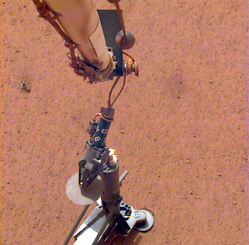 NASA’s InSight lander has placed its second instrument on the Martian surface. New images confirm that the Heat Flow and Physical Properties Package, or HP3, was successfully deployed on Feb. 12 about 3 feet (1 meter) from InSight’s seismometer, which the lander recently covered with a protective shield. HP3measures heat moving through Mars’ subsurface and can help scientists figure out how much energy it takes to build a rocky world.
Equipped with a self-hammering spike, mole, the instrument will burrow up to 16 feet (5 meters) below the surface, deeper than any previous mission to the Red Planet. For comparison, NASA’s Viking 1 lander scooped 8.6 inches (22 centimeters) down. The agency’s Phoenix lander, a cousin of InSight, scooped 7 inches (18 centimeters) down.
“We’re looking forward to breaking some records on Mars,” said HP3 Principal Investigator Tilman Spohn of the German Aerospace Center (DLR), which provided the heat probe for the InSight mission. “Within a few days, we’ll finally break ground using a part of our instrument we call the mole.” [More at link]
MARCI weather report, February 4-10, 2019.
 Dust storm activity was at a minimum across the tropics and southern highlands of Mars last week. Local storms were observed along the seasonal north polar cap edge, while the polar vortex showed a wave-2 type structure, typical this time of season. Water ice clouds remained above the southernmost volcano of the Tharsis Montes most afternoons. Skies were storm-free for the rover and lander sites of Curiosity (Gale Crater), InSight (Elysium Planitia), and Opportunity (Endeavour Crater) each sol. [More at link, including video]
Posted in Reports
Tagged atmosphere, clouds, dust, dust storms, global dust storms, haze, Malin Space Science Systems, MARCI, Mars Color Imager, Mars Reconnaissance Orbiter, MRO, MSSS, NASA, storms, weather, wind
Comments Off