HiRISE: Jumbled blocks on the floor of Melas Chasma

ESP_058527_1695This part of Melas Chasma has been the target for many previous HiRISE images due to its diversity of terrains and materials. This observation covers an area not previously imaged, revealing a chaotic jumble of bright layered sediments, perhaps resulting from large landslides.

In a closeup with enhanced colors, we can see an assortment of materials. Dark sand covers the low areas of the scene. [More at link]

Posted in Reports | Tagged , , , , , , , , | Comments Off

THEMIS: Pasteur Crater in false color

Pasteur Crater in false color (THEMIS_IOTD_20190220)THEMIS Image of the Day, February 20, 2019. Today’s image shows part of the floor of Pasteur Crater. The deposit in the southwest part of the floor is a fill deposit that is undergoing erosion. Small sand dunes are found within the eroding material. Pasteur Crater is located between Arabia Terra and Terra Sabaea.

The THEMIS VIS camera contains 5 filters. The data from different filters can be combined in multiple ways to create a false color image. These false color images may reveal subtle variations of the surface not easily identified in a single band image.

See more THEMIS Images of the Day by geological subject.

Posted in Reports | Tagged , , , , , , , , , , , | Comments Off

Latest weather at Gale Crater and Elysium Planitia

Daily Elysium charts and data (temperature, wind speed, atmospheric pressure) here.

Posted in Reports | Tagged , , , , , , , , , , , , , , , | Comments Off

HiRISE: Almost like water

ESP_057978_1875This image in Athabasca Valles shows lava flows originating from Elysium Mons to the northwest. A Context Camera image shows the lava flowed from the northwest to the southeast, diverting around obstacles as it settled. (The flow is outlined in blue with the flow direction shown in yellow, and the approximate location of the HiRISE image is represented by a white rectangle.)

The lava appears to have flowed smoothly around obstructions, almost like water, forming streamlined islands. In the southern part of this image, a branch of the flow diverts around a small crater, and eventually rejoins the main part of the flow. Irregular-shaped ring structures appear on the northern end and are related to the volcanic activity that formed the flows…. [More at link]

Posted in Reports | Tagged , , , , , , , , | Comments Off

InSight: New Mars weather service

PIA22876-mainNo matter how cold your winter has been, it’s probably not as chilly as Mars. Check for yourself: Starting today, the public can get a daily weather report from NASA’s InSight lander.

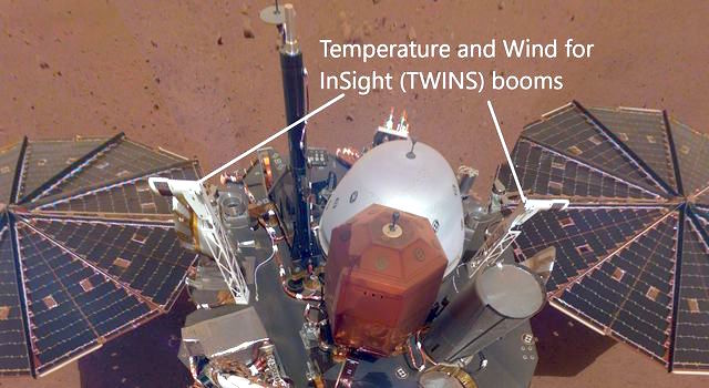
This public tool includes stats on temperature, wind and air pressure recorded by InSight. Sunday’s weather was typical for the lander’s location during late northern winter: a high of 2 degrees Fahrenheit (-17 degrees Celsius) and low of -138 degrees Fahrenheit (-95 degrees Celsius), with a top wind speed of 37.8 mph (16.9 m/s) in a southwest direction. The tool was developed by NASA’s Jet Propulsion Laboratory in Pasadena, California, with partners at Cornell University and Spain’s Centro de Astrobiología. JPL leads the InSight mission.

Through a package of sensors called the Auxiliary Payload Subsystem (APSS), InSight will provide more around-the-clock weather information than any previous mission to the Martian surface. The lander records this data during each second of every sol (a Martian day) and sends it to Earth on a daily basis. The spacecraft is designed to continue that operation for at least the next two Earth years, allowing it to study seasonal changes as well.

The tool will be geeky fun for meteorologists while offering everyone who uses it a chance to be transported to another planet.

“It gives you the sense of visiting an alien place,” said Don Banfield of Cornell University, in Ithaca, New York, who leads InSight’s weather science. “Mars has familiar atmospheric phenomena that are still quite different than those on Earth.” [More at links]
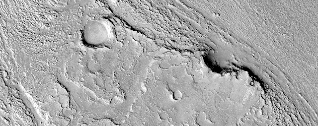
Posted in Reports | Tagged , , , , , , , | Comments Off

THEMIS: Herschel Crater floor in false color

Herschel Crater in false color (THEMIS_IOTD_20190219)THEMIS Image of the Day, February 19, 2019. This VIS image shows part of the floor of Herschel Crater.

Sand dunes are visible at the bottom of the image. The dark blue in this false color image typically indicates basaltic sands. Early morning shadows can be seen to the left of the hills at the center of the image. Herschel Crater is located in Terra Cimmeria.

The THEMIS VIS camera contains 5 filters. The data from different filters can be combined in multiple ways to create a false color image. These false color images may reveal subtle variations of the surface not easily identified in a single band image.

See more THEMIS Images of the Day by geological subject.

Posted in Reports | Tagged , , , , , , , , , , , | Comments Off

HiRISE: Recent impact site in Noachis Terra

ESP_057984_1490This image shows a recent impact in Noachis Terra in the southern mid-latitudes of Mars. The impact occurred in dark-toned ejecta material from a degraded, 60-kilometer crater to the south.

Rather than a single impact crater, we see multiple impacts like a shotgun blast. This suggests that the impactor broke up in the atmosphere on entry. Although the atmosphere of Mars is thinner than Earth’s, it still has the capacity to break up small impactors, especially ones comprised of weaker materials, like a stony meteoroid versus a iron-nickel one.

Our image depicts 21 distinctive craters ranging in size from 1 to 7 meters in diameter. They are distributed over an area that spans about 305 meters. Most observed recent impacts expose darker-toned materials underlying bright dusty surfaces. However, this impact does the opposite, showing us lighter-toned materials that lie beneath a darker colored surface… [More at link]

Posted in Reports | Tagged , , , , , , , , , , | Comments Off

JPL: Mars 2020 build update

Posted in Reports | Tagged , , , , , , | Comments Off

THEMIS: Mawrth Vallis in false color

Mawrth Vallis in false color (THEMIS_IOTD_20190218)THEMIS Image of the Day, February 18, 2019. Mawrth Vallis, a fluvial channel, cuts across the center of this false-color VIS image of Arabia Terra.

The THEMIS VIS camera contains 5 filters. The data from different filters can be combined in multiple ways to create a false color image. These false color images may reveal subtle variations of the surface not easily identified in a single band image.

See more THEMIS Images of the Day by geological subject.

Posted in Reports | Tagged , , , , , , , , , , | Comments Off

Curiosity update: Onwards to Midland Valley

FLA_603291107EDR_F0740210FHAZ00337M_-br2Sols 2320-23, February 14, 2019, update by MSL scientist Catherine O’Connell: Today was a very busy planning day for the Curiosity operations team. We planned a 3-sol plan, with contact science, imaging, environmental monitoring and a drive.

Our weekend plan brought us to a block of coherent rock, a treat after spending many workspaces in more broken up and rubbly areas. The Geology (GEO) theme group uplinked lots of contact science here on Monday, so we are ready to leave and drive on to the next coherent block we have identified in the distance, a target known as “Midland Valley.” Before leaving however, we planned contact science on “Ladder Hills,” a beautiful example of laminated bedrock. APXS will be used to determine the chemistry, to compare it to our other targets in this workspace “Gannet” and “Curlew.” MAHLI will take images of the laminations within Ladder Hills from two different angles – straight downwards onto the rock surface (the spot where APXS will also analyze), and from an oblique angle. ChemCam will acquire active LIBS (laser) analysis of Ladder Hills, in addition to analysis of “Fyvie,” a large pebble for comparison with bedrock targets… [More at link]

Posted in Reports | Tagged , , , , , , , , , , , , , , , , , , | Comments Off