Beyond Mars, the mini MarCO spacecraft fall silent

PIA22655Before the pair of briefcase-sized spacecraft known collectively as MarCO launched last year, their success was measured by survival: If they were able to operate in deep space at all, they would be pushing the limits of experimental technology.

Now well past Mars, the daring twins seem to have reached their limit. It’s been over a month since engineers have heard from MarCO, which followed NASA’s InSight to the Red Planet. At this time, the mission team considers it unlikely they’ll be heard from again.

MarCO, short for Mars Cube One, was the first interplanetary mission to use a class of mini-spacecraft called CubeSats. The MarCOs — nicknamed EVE and WALL-E, after characters from a Pixar film — served as communications relays during InSight’s landing, beaming back data at each stage of its descent to the Martian surface in near-real time, along with InSight’s first image. WALL-E sent back stunning images of Mars as well, while EVE performed some simple radio science. (…)

WALL-E was last heard from on Dec. 29; EVE, on Jan. 4. Based on trajectory calculations, WALL-E is currently more than 1 million miles (1.6 million kilometers) past Mars; EVE is farther, almost 2 million miles (3.2 million kilometers) past Mars… [More at link]

Posted in Reports | Tagged , , , , , , | Comments Off

Curiosity update: Targeting small bedrock patches, pebbles, and soil

2308MH0002970010803881C00_DXXX-br2Sols 2311-12, February 4, 2019, update by MSL scientist Roger Wiens: The accompanying image shows the target “Brent” in the lower right corner; it was analyzed with ChemCam and APXS, and imaged with MAHLI over the weekend. It is a rounded pebble roughly an inch (2.5 cm) in diameter. In spite of the fact that it has been rounded by mechanical abrasion, it still shows faint layering. You can also see inclusions that are partially filled with brighter material. Marching vertically across the face of the pebble are five laser pits from ChemCam. The bottom of each pit has a telltale whitish appearance.

Over the weekend Curiosity completed a 20-meter drive. Curiosity is heading east and will be driving below the upper side of Vera Rubin Ridge, toward waypoint 2. One of the goals for this portion of the traverse is to image the rock layers along its upper slope, but so far the slope appears to be mostly covered with soil. Today’s plan includes observations of what appears to be small bedrock targets, with Mastcam, APXS, ChemCam, and MAHLI observations of target “Isbister,” ChemCam RMI-only… [More at link]

Posted in Reports | Tagged , , , , , , , , , , , , , , , , | Comments Off

HiRISE: A variety of surfaces and terrains

ESP_045205_2295A variety of surfaces and terrains. This intriguing extraterrestrial terrain is located in the far northeast part of Acidalia Planitia, located between the Tharsis volcanic province and Arabia Terra to the north of Valles Marineris.

HiRISE Picture of the Day archive [More at links]

Posted in Reports | Tagged , , , , , , , , | Comments Off

THEMIS: Sea of dunes in Rabe Crater

Sea of dunes in Rabe Crater (THEMIS_IOTD_20190205)THEMIS Image of the Day, February 5, 2019. This VIS image shows part of the floor of Rabe Crater. The floor of Rabe Crater has undergone several surface changing events.

At some point after the crater was formed it was partially filled by a material laid down by wind or water action. This material has been eroded, creating a complex depression in the deposited material. The resultant sand has collected into the dunes seen in the image.

See more THEMIS Images of the Day by geological subject.

Posted in Reports | Tagged , , , , , , , , , | Comments Off

InSight: Seismometer now has a cozy shelter

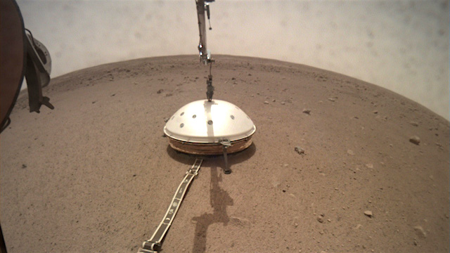
PIA22959-16For the past several weeks, NASA’s InSight lander has been making adjustments to the seismometer it set on the Martian surface on Dec. 19. Now it’s reached another milestone by placing a domed shield over the seismometer to help the instrument collect accurate data. The seismometer will give scientists their first look at the deep interior of the Red Planet, helping them understand how it and other rocky planets are formed.

The Wind and Thermal Shield helps protect the supersensitive instrument from being shaken by passing winds, which can add “noise” to its data. The dome’s aerodynamic shape causes the wind to press it toward the planet’s surface, ensuring it won’t flip over. A skirt made of chain mail and thermal blankets rings the bottom, allowing it to settle easily over any rocks, though there are few at InSight’s location.

An even bigger concern for InSight’s seismometer — called the Seismic Experiment for Interior Structure (SEIS) — is temperature change, which can expand and contract metal springs and other parts inside the seismometer. Where InSight landed, temperatures fluctuate by about 170 degrees Fahrenheit (94 degrees Celsius) over the course of a Martian day, or sol.

“Temperature is one of our biggest bugaboos,” said InSight Principal Investigator Bruce Banerdt of NASA’s Jet Propulsion Laboratory in Pasadena, California. JPL leads the InSight mission and built the Wind and Thermal Shield. “Think of the shield as putting a cozy over your food on a table. It keeps SEIS from warming up too much during the day or cooling off too much at night. In general, we want to keep the temperature as steady as possible.”  [More at link]

Posted in Reports | Tagged , , , , , , , , , , , | Comments Off

ExoMars: Eberswalde Crater delta

Eberswalde_crater_deltaThis intricate structure of an ancient river delta once carried liquid water across the surface of Mars.

The distinctive form of a delta arises from sediments that are deposited by a river as it enters slower-moving water, like a lake or a sea, for example. The Nile River delta is a classic example on Earth, and uncannily similar features have been spotted on Saturn’s moon Titan and – closer to home – Mars. While liquid water is no longer present on the surface of Mars, features in the left portion of this image provide strong evidence of it having played an important role in the history of the Red Planet. Furthermore, water-ice is still stable on the surface today, and a recent discovery from Mars Express detected a pocket of liquid water below the surface.

The 100-metre-thick fan-shaped deposit seen in this image is found in Eberswalde crater in the southern hemisphere of Mars (326.33ºE/23.55ºS). The image covers an area of 31 x 7.5 km and was taken on 16 November 2018 by the Colour and Stereo Surface Imaging System (CaSSIS) of the ESA-Roscosmos ExoMars Trace Gas Orbiter.

While presented in beautiful aqueous blues and greens, the image is false-colour. The layered rocks that comprise the delta deposits are indicated in white/yellow to purple/blue. The yellow represents the presence of oxidised iron deposits, indicating that the rocks were altered by the presence of water, while the blues signify less altered materials. This suggests that the influence of liquid water reduced over time, perhaps relating to a change in environmental conditions… [More at link]

Posted in Reports | Tagged , , , , , , , , , | Comments Off

Opportunity report, Sol 5341, by A.J.S. Rayl, The Planetary Society

20190202_1-HiRISE-Nov-2018_f840February 2, 2019: Opportunity Logs 15th Year in Silence, Team Begins ‘Hail Mary’ Efforts: As a string of dust storms moved through Meridiani Planum and over Endeavour Crater in January, Opportunity silently wrapped her fifteenth year on the surface of Mars. While the storms raised enough dust to turn the skies noticeably hazy all around the planet, they also raised hope that Mars might gift the veteran robot field geologist with gusts that would finally clear the ‘bot’s solar arrays and enable her to recharge, wake-up, and phone home.

But at month’s end, the Mars Exploration Rovers (MER) team and colleagues at the Deep Space Network (DSN) neither saw nor heard any sign of the legendary robot. At the Jet Propulsion Laboratory (JPL), where all of NASA’s Red Planet explorers have been born, Opportunity’s 15th anniversary came and went quietly in the halls of MER.

After spending seven and a half months reaching out to and listening for the longest-lived robot on Mars and transmitting more than 600 recovery commands, the silence is deafening for the team. Still, no one is giving up, not yet.

“We’re still trying,” said MER Principal Investigator Steve Squyres, of Cornell University. “We’re still in the window when we’ve seen cleaning events in the past and we are continuing to attempt to communicate with the rover in every way we can.”

With NASA’s support, the MER team is committed to doing everything possible to make contact with the record-setting, crater-hopping, marathon-roving veteran explorer loved around the world. To that end, within hours of the Opportunity’s 15th anniversary, the operations engineers began launching a series of last-ditch efforts. (…)

Posted in Reports | Tagged , , , , , , | Comments Off

HiRISE: Bedrock delights

ESP_054578_1985-2Bedrock delights. These gorgeous bedrock formations are located in the Syrtis Major region, which is a low-relief shield volcano.

HiRISE Picture of the Day archive [More at links]

Posted in Reports | Tagged , , , , , , , , , , | Comments Off

THEMIS: Polar cap layers at Ultima Lingula

Polar layers (THEMIS_IOTD_20190204)THEMIS Image of the Day, February 4, 2019. Today’s VIS image is located along the margin of Ultima Lingula, where the polar cap meets the surrounding plains.

The feature in the center of the image is a chasma where the ice has eroded down the the surface of the plains. The extensive layering of the polar ice was created by seasonal deposits of ice and dust.

See more THEMIS Images of the Day by geological subject.

Posted in Reports | Tagged , , , , , , , , , | Comments Off

Curiosity update: Atop another (smaller) ridge

NLA_602216832EDR_F0732502NCAM00267M_-br2Sols 2308-10, February 1, 2019, update by MSL scientist Vivian Sun: Curiosity successfully completed her drive yesterday and is currently parked on top of one of the ridges (“Knockfarril Hill”) in the clay-bearing unit. One of the mysteries of the clay unit is the origin of these ridges – how did they form and what are they made of? This weekend’s 3-sol plan is packed with observations designed to start addressing these questions.

The current workspace in front of Curiosity is very rubbly, with no bedrock that is reachable by the rover arm. However, most of the clay-bearing unit is likely composed of this rubbly material, so it’s important to characterize its composition and texture. To that end, we will acquire APXS measurements of this material on Sol 2308, using a rastering technique where the APXS will be placed over three overlapping spots in the workspace. By obtaining chemical measurements over different, but slightly overlapping areas, we will be able to distinguish the compositions of the pebbles from the sand and soil in the APXS field of view.

We will also analyze the variety of pebbles in our workspace with ChemCam on “Brent” (also the APXS target), “Carluke,” and “Foveran.” In a happy coincidence, we had identified Carluke as a ChemCam target before we learned that the previous plan’s ChemCam AEGIS observation had autonomously selected the same Carluke pebble to analyze! We decided to keep the Carluke observation in any case, to gather better statistics on the chemical variability in this pebble… [More at link]

Posted in Reports | Tagged , , , , , , , , , , , , , , | Comments Off