


-
Recent Posts
Archives
Links
general
mission instruments
- CRISM: Compact Reconnaissance Imaging Spectrometer for Mars
- CTX: Context Camera
- HiRISE: High Resolution Imaging Science Experiment
- MARSIS: Mars Advanced Radar for Subsurface and Ionosphere Sounding
- SHARAD: Shallow Radar
- THEMIS: Thermal Emission Imaging System
missions
- All Mars missions list
- Curiosity rover
- ExoMars
- Hope (al-Amal) orbiter
- InSight
- Mars Atmosphere and Volatile Evolution Mission (MAVEN)
- Mars Exploration Rovers (MER)
- Mars Express (MEX)
- Mars Odyssey
- Mars Orbiter Mission (MOM) / Mangalyaan
- Mars Reconnaissance Orbiter (MRO)
- Mars Science Laboratory (MSL)
- Perseverance Rover
- Tianwen-1 orbiter/rover
news
Weather at Gale Crater
Posted in Reports
Tagged Curiosity, dust storms, Gale Crater, Mars Science Laboratory, MSL, NASA, temperature, weather
Comments Off
HiRISE: For your consideration
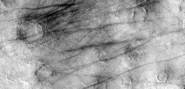 For your consideration. An alien landscape with dust devil streaks and craters slowing fading away into the mists of time. A twilight zone of geology, if you will. (Features like this are often called “thumbprint terrain”.)
HiRISE Picture of the Day archive [More at links]
Posted in Reports
Tagged Diacria, dust devil tracks, High Resolution Imaging Science Experiment, HiPOD, HiRISE, HiRISE Picture of the Day, Mars Reconnaissance Orbiter, MRO, NASA, northern lowlands, northern plains, thumbprint terrain, University of Arizona
Comments Off
Curiosity: Looking ahead, and farther ahead
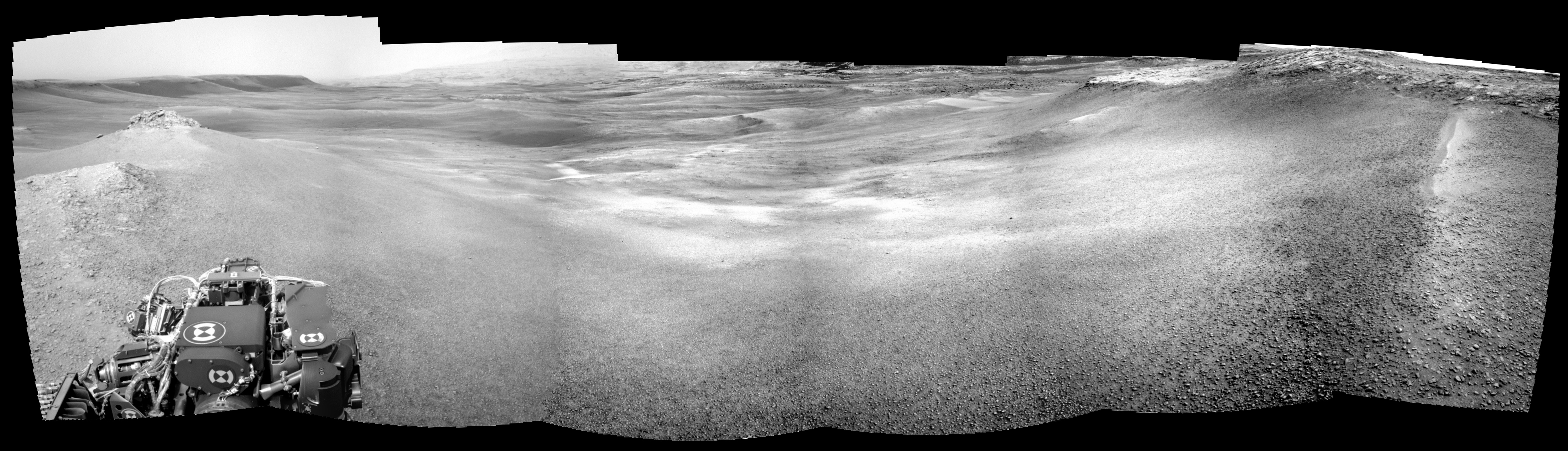 Sol 2306, January 31, 2019. Curiosity’s Navcam took a composite showing the rolling surface of the clay-bearing unit directly before the rover (above), while the Remote Micro-Imager looked off into the distance to profile a hill (below). Click either image to enlarge it.
Sol 2306 raw images (from all cameras).
Posted in Reports
Tagged Aeolis Mons, CBU, clay-bearing unit, Curiosity, Gale Crater, Mars Science Laboratory, Mount Sharp, MSL, Murray Formation, NASA, Vera Rubin Ridge
Comments Off
THEMIS: Lava flows and channels on Daedalia Planum
 THEMIS Image of the Day, February 1, 2019. Today’s VIS image shows a small portion of the extensive volcanic plains of Daedalia Planum.
These lava flows originated from Arsia Mons, the southernmost of the three large Tharsis volcanoes.
Posted in Reports
Tagged Arizona State University, Arsia Mons, ASU, Daedalia Planum, lava channels, lava flows, Mars Odyssey, NASA, THEMIS, THEMIS Image of the Day, Thermal Emission Imaging System, volcanics
Comments Off
MARCI weather report, January 21-27, 2019
 and Curiosity") Elevated levels of atmospheric dust, remnants of a recently abated southern hemisphere regional storm, lingered over most of Mars this past week. At high southern latitudes, the perennial south polar ice cap had reached its minimum summer configuration. While in the northern lowlands, the seasonal receding north polar cap edge could be observed under a mixture of dust and water-ice clouds associated with the north polar hood and eastward propagating polar vortex. Each afternoon, the Tharsis Montes and other areas in the tropics were free of water-ice clouds. This was due… [More at link, including video]
Elevated levels of atmospheric dust, remnants of a recently abated southern hemisphere regional storm, lingered over most of Mars this past week. At high southern latitudes, the perennial south polar ice cap had reached its minimum summer configuration. While in the northern lowlands, the seasonal receding north polar cap edge could be observed under a mixture of dust and water-ice clouds associated with the north polar hood and eastward propagating polar vortex. Each afternoon, the Tharsis Montes and other areas in the tropics were free of water-ice clouds. This was due… [More at link, including video]
Posted in Reports
Tagged atmosphere, clouds, dust, dust storms, haze, Malin Space Science Systems, MARCI, Mars Color Imager, Mars Reconnaissance Orbiter, MRO, MSSS, NASA, storms, weather, wind
Comments Off
HiRISE: Landforms northwest of Herschel Crater
 Landforms northwest of Herschel Crater. Herschel Crater is a 304 kilometer impact basin in the Martian Southern Hemisphere. We have imaged the crater enough times to learn that dunes here are not stationary but move over time. The crater is jointly named after the seventeenth/eighteenth century father and son astronomers William Herschel and John Herschel.
HiRISE Picture of the Day archive [More at links]
Posted in Reports
Tagged dunes, Herschel Crater, High Resolution Imaging Science Experiment, HiPOD, HiRISE, HiRISE Picture of the Day, Mars Reconnaissance Orbiter, MRO, NASA, sand dunes, University of Arizona
Comments Off
Curiosity measures a Mars mountain’s gravity
 Ed. note: More about this result here, here, and here.
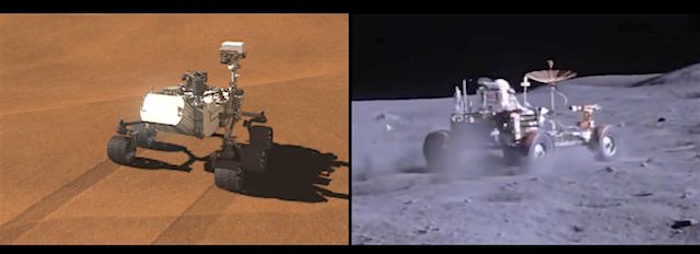
Apollo 17 astronauts drove a moon buggy across the lunar surface in 1972, measuring gravity with a special instrument. There are no astronauts on Mars, but a group of clever researchers realized they have just the tools for similar experiments with the Martian buggy they’re operating.
In a new paper in Science, the researchers detail how they repurposed sensors used to drive the Curiosity rover and turned them into gravimeters, which measure changes in gravitational pull. That enabled them to measure the subtle tug from rock layers on lower Mount Sharp, which rises 3 miles (5 kilometers) from the base of Gale Crater and which Curiosity has been climbing since 2014. The results? It turns out the density of those rock layers is much lower than expected.
Just like a smartphone, Curiosity carries accelerometers and gyroscopes. Moving your smartphone allows these sensors to determine its location and which way it’s facing. Curiosity’s sensors do the same thing but with far more precision, playing a crucial role in navigating the Martian surface on each drive. Knowing the rover’s orientation also lets engineers accurately point its instruments and multidirectional, high-gain antenna.
By happy coincidence, the rover’s accelerometers can be used like Apollo 17′s gravimeter. The accelerometers detect the gravity of the planet whenever the rover stands still. Using engineering data from the first five years of the mission, the paper’s authors measured the gravitational tug of Mars on the rover. As Curiosity ascends Mount Sharp, the mountain adds additional gravity – but not as much as scientists expected… [More at links]
Posted in Reports
Tagged Aeolis Mons, Curiosity, Gale Crater, gravity, Mars Science Laboratory, Mount Sharp, MSL, NASA
Comments Off
Curiosity update: Stepping up to the edge
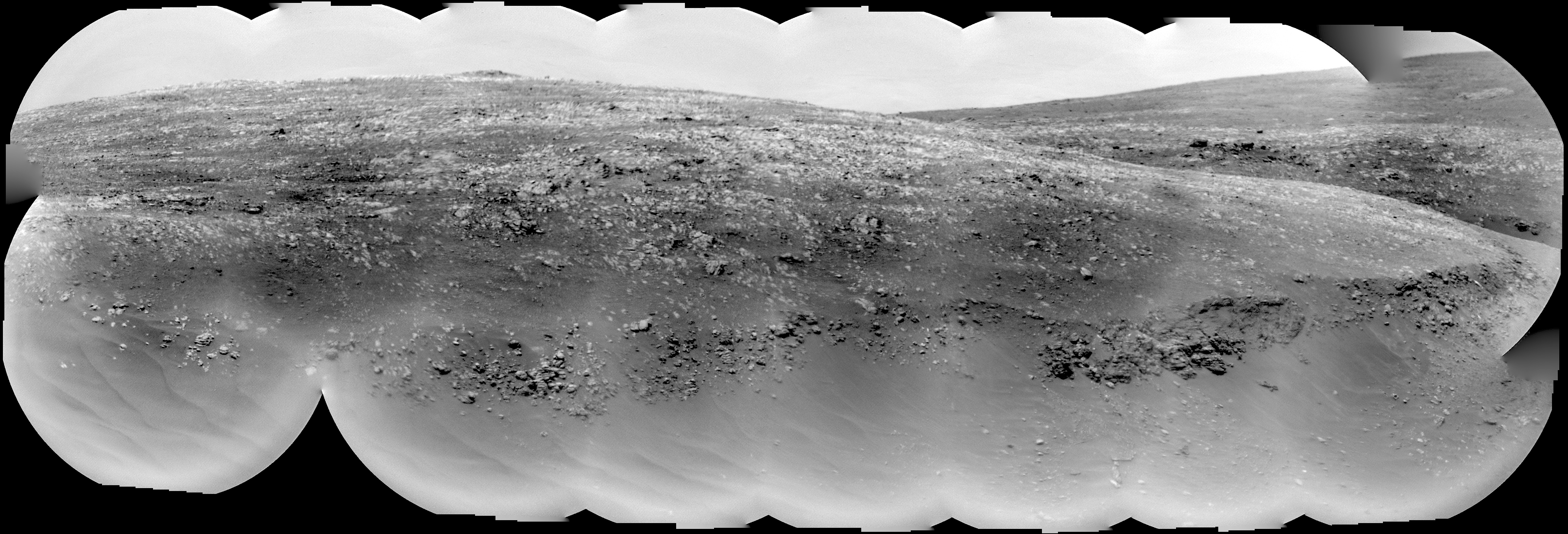
 on Sol 2304 Credit: NASA/JPL-Caltech") Sols 2306-07, January 30, 2019, update by MSL engineer Ashley Stroupe: In today’s plan, Curiosity is venturing further into the clay unit territory.
Sols 2306-07, January 30, 2019, update by MSL engineer Ashley Stroupe: In today’s plan, Curiosity is venturing further into the clay unit territory.
Prior to departure, we’ll be looking at several targets with Mastcam color and ChemCam to try to characterize the chemistry and texture of this new terrain. We’ll also be taking a ChemCam RMI mosaic of “Buchan Ridge,” an upcoming area of exploration within the clay unit, to aid in navigation and traverse planning.
We’re driving up to the crest of a ridge so that we will be able to see down the other side, which is currently hidden from our view. The new terrain is so featureless, that visual odometry is having trouble tracking our position and measuring slip, which caused the rover to stop the sol 2304 drive early. The image above (Sol 2304 post-drive Navcam) shows the ridge and the smooth terrain. The rover planners are using some extra imaging to help us characterize how the rover performs on this new terrain. We are hoping something of interest will be in our workspace for contact science in the weekend plan. Much of… [More at link]
Posted in Reports
Tagged Aeolis Mons, Buchan Ridge, CBU, clay-bearing unit, Curiosity, Gale Crater, Mars Science Laboratory, Mount Sharp, MSL, Murray Formation, NASA
Comments Off
THEMIS: Eroding layers in Spallanzani Crater
 THEMIS Image of the Day, January 31, 2019. This VIS image shows part of the floor of Spallanzani Crater. At some point after the crater was created the floor was covered by a fill material.
The material was laid down in layers, which are easily identifiable at the eroded margins of the desposit. Spallanzani Crater is located near the southeast margin of Hellas Planitia in Promethei Terra.
Posted in Reports
Tagged Arizona State University, ASU, ice-rich mantling, layered deposits, Mars Odyssey, NASA, Promethei Terra, Spallanzani Crater, THEMIS, THEMIS Image of the Day, Thermal Emission Imaging System
Comments Off
Curiosity: Scoping Greenheugh
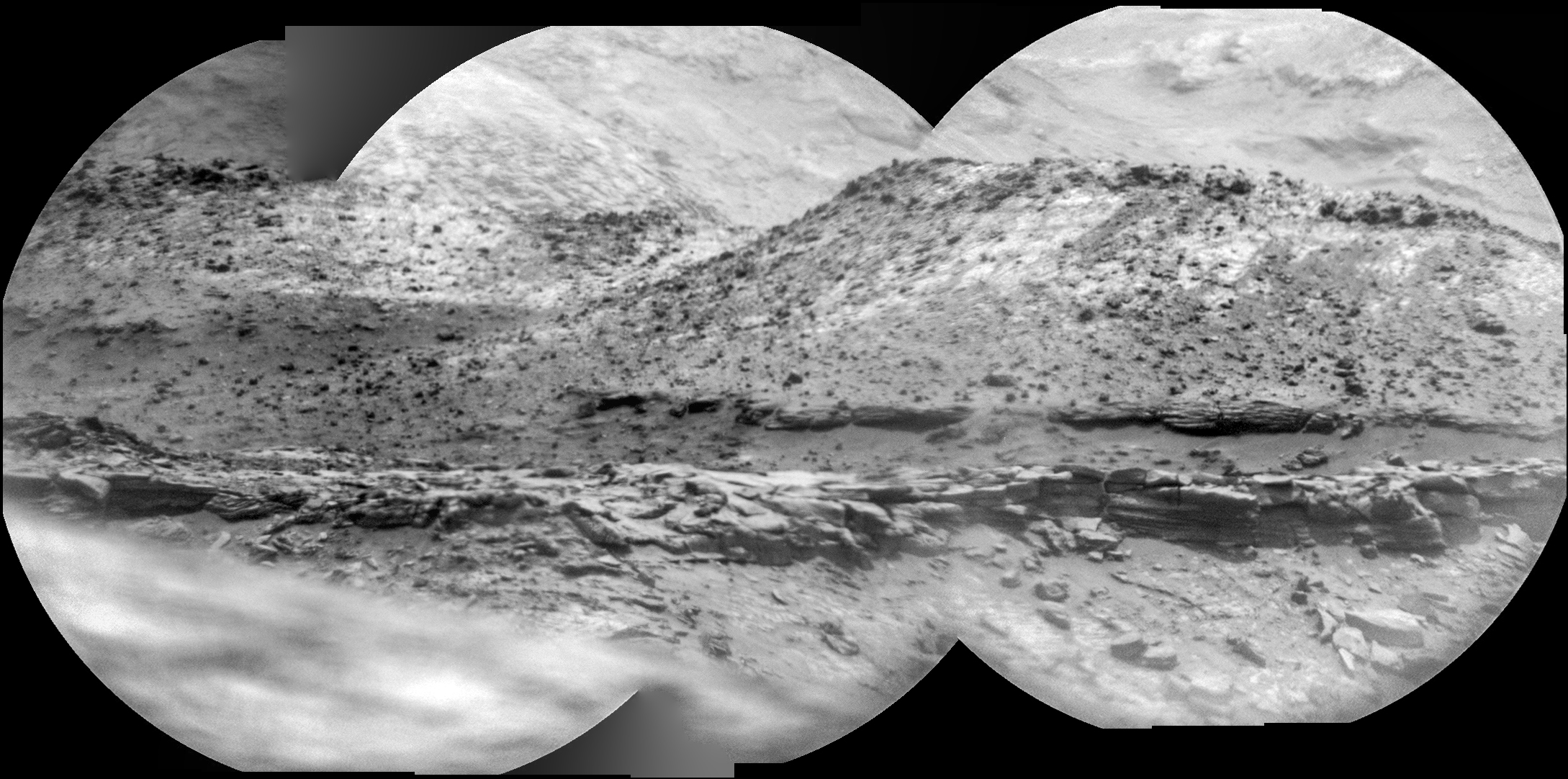 Sol 2304, January 29, 2019. Curiosity used its Remote Micro-Imager to scope out a distant butte dubbed Greenheugh. Note the layers of sedimentary rocks. Click the image to enlarge it.
Posted in Reports
Tagged Aeolis Mons, CBU, clay-bearing unit, Curiosity, Gale Crater, Greenheugh, Mars Science Laboratory, Mount Sharp, MSL, NASA
Comments Off