


 THEMIS Image of the Day, August 15, 2019. This VIS image shows a small section of Indus Vallis. Indus Vallis is located in northern Terra Sabaea.
Explore more THEMIS Images of the Day by geological subject.
THEMIS Image of the Day, August 15, 2019. This VIS image shows a small section of Indus Vallis. Indus Vallis is located in northern Terra Sabaea.
Explore more THEMIS Images of the Day by geological subject.
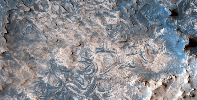 Layers in a depression that are not depressing. Wherein we revel at the stratigraphic gorgeousness of a small area in Sinus Meridiani on the fourth planet from the Sun. Sinus Meridiani was named by the French astronomer Camille Flammarion in the late 1870s.
HiRISE Picture of the Day archive. [More at links]
 THEMIS Image of the Day, August 14, 2019. Today’s VIS image shows a small field of sand dunes on the floor of Bamberg Crater.
At the top of the image is a small group of peaks forming a rough circle. This is Bamberg Crater’s central peak ring; as impact craters increase in size, their peak rings grow in diameter.
Explore more THEMIS Images of the Day by geological subject.
 Sols 2495-96, August 12, 2019, update by MSL scientist Vivian Sun: Today’s planning began with a bit of a shuffle as we learned that the sample cup that was used for SAM preconditioning over the weekend didn’t seal as well as desired. This preconditioning step is required before we can perform SAM Evolved Gas Analysis (EGA) on the “Glen Etive” drill sample. In response, we elected to redo the SAM preconditioning activity using another cup, in addition to running another CheMin analysis. These changes freed up additional time for remote sensing observations in this 2 sol plan.
We planned a variety of ChemCam observations, including a retargeting of the Glen Etive drill hole in order to better adjust the focus parameters. We identified a rock called “Scone” with nicely exposed layers that we will sample with a vertical raster, and will also target another bedrock target called “Crannog.” There was also time to take a long distance RMI mosaic of the sulfate unit to image sedimentary structures… [More at link]
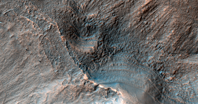 Layers near the top of a crater. With our camera’s resolution, we can find out if these layers on the top of a crater in Terra Cimmeria are actually within a block of material.
HiRISE Picture of the Day archive. [More at links]
 On July 24, 1969, Apollo 11 command module Columbia splashed down in the Pacific, fulfilling President Kennedy’s goal to land a man on the Moon and return him safely to Earth. Among the mission’s many firsts was the acquisition and return of the first samples from another celestial body. Findings based on the 47 pounds (21.5 kilograms) of lunar rock and soil rewrote the textbooks on both the Moon and solar system, and the samples are still being studied today by researchers using new and more sensitive instruments.
With its launch window opening on July 17, 2020 – less than a year from today – NASA’s Mars 2020 rover will mark another first: The roverwill not only seek signs of ancient habitable conditions and past microbial life but will collect rock and soil samples, storing them on the planet’s surface for a future mission to retrieve.
“Apollo 11 demonstrated the immense value of returning samples from other worlds for analysis here on Earth,” said Thomas Zurbuchen,NASA’s associate administrator for the Science Mission Directorate. “Today, we are standing on the shoulders of Apollo, preparing for the launch of the initial step in humanity’s first roundtrip and sample return from another planet – Mars.” [More at link]
 THEMIS Image of the Day, August 13, 2019. Today’s VIS image has a channel dissecting a crater rim, flowing from the interior of a large crater into a smaller crater on the large crater’s floor. The two craters are unnamed and located in northern Terra Sabaea.
Explore more THEMIS Images of the Day by geological subject.
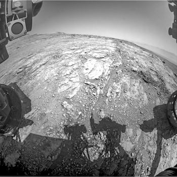
 on Sol 2490 Credit: NASA/JPL-Caltech/LANL") Sols 2492-94, August 12, 2019, update by MSL scientist Brittney Cooper: It’s the end of another week on Mars, and today we put together a 3 sol weekend plan for Curiosity. Given the RSM-related issues that we incurred this past week, we are still being cautious, but the diagnostic testing that ran in the last plan was successful.
Sols 2492-94, August 12, 2019, update by MSL scientist Brittney Cooper: It’s the end of another week on Mars, and today we put together a 3 sol weekend plan for Curiosity. Given the RSM-related issues that we incurred this past week, we are still being cautious, but the diagnostic testing that ran in the last plan was successful.
To exercise that caution, we began planning this morning with a little shuffle of science blocks to ensure that any observations that have the RSM pointing above the horizon are run prior to last the satellite communications pass that will transmit data to the team in time for planning on Monday morning.
Our plan begins with a hefty two hour science block on the first sol that features both a Mastcam tau and crater rim extinction observation to measure the amount of dust and clouds in the atmosphere. The Mastcam images are then followed by two alternating ChemCam LIBS and RMI observations of bedrock and crushed rock (targets “Glen Affric” and “Grey Corries,” respectively)… [More at link]
 Wind erosion has been ruled out as the primary cause of methane gas release on Mars, Newcastle University academics have shown.
Methane can be produced over time through both geological and biological routes and since its first detection in the Martian atmosphere in 2003, there has been intense speculation about the source of the gas and the possibility that it could signal life on the planet.
Previous studies have suggested the methane may not be evenly distributed in the atmosphere around Mars, but instead appear in localised and very temporary pockets on the planet’s surface. And the previous discovery of methane ‘spikes’ in the Martian atmosphere has further fuelled the debate.
Now research led by Newcastle University, UK, and published in Nature Scientific Reports, has ruled out the possibility that the levels of methane detected could be produced by the wind erosion of rocks, releasing trapped methane from fluid inclusions and fractures on the planets’ surface.
Principal Investigator Dr Jon Telling, a geochemist based in the School of Natural and Environmental Sciences at Newcastle University, said, “The questions are – where is this methane coming from, and is the source biological? That’s a massive question and to get to the answer we need to rule out lots of other factors first.
“We realised one potential source of the methane that people hadn’t really looked at in any detail before was wind erosion, releasing gases trapped within rocks. High resolution imagery from orbit over the last decade have shown that winds on Mars can drive much higher local rates of sand movement, and hence potential rates of sand erosion, than previously recognised…” [More at links]
 Valleys in Melas Chasma. Caption throwback (2008): The interpretation is that the valleys formed by precipitation in the late Hesperian epoch and the water that formed them collected in the basin to produce a lake where sediment was deposited. This location is therefore particularly interesting to scientists because it shows water activity that resulted from rain in a relatively young region near the equator of Mars.
HiRISE Picture of the Day archive. [More at links]