THEMIS: Yardangs in Candor Chasma

Yardangs in Candor Chasma (THEMIS_IOTD_20190122)THEMIS Image of the Day, January 22, 2019. This VIS image shows part of the eastern end of Candor Chasma. The upper edge of the canyon is at the bottom of the image.

The slopes of the chasma are eroded into a series of ridges and valleys. Winnowing of unconsolidated sediments by long term unidirectional winds can create these features. The ridges and valleys are called yardangs.

See more THEMIS Images of the Day by geological subject.

Posted in Reports | Tagged , , , , , , , , , | Comments Off

Weather at Gale Crater

Posted in Reports | Tagged , , , , , , , | Comments Off

Curiosity: Distant buttes

2295-rmiSol 2295, January 20, 2019. The Remote Micro-Imager reached out to profile distant layered buttes on the flanks of Mt. Sharp. Click image to enlarge it.

Sol 2295 raw images (from all cameras).

Posted in Reports | Tagged , , , , , , , , , | Comments Off

THEMIS: Out of round

Out of round (THEMIS_IOTD_20190121)THEMIS Image of the Day, January 21, 2018. This VIS image shows a group of craters in Terra Sirenum. The apparent youngest one is the center crater with the scalloped rim.

Subsurface tectonic features like faults can interfere with crater formation and lead to craters that are not completely circular. The linear fault features towards the bottom of the image are good indications that tectonic faults interacted with the impact event, resulting in the crater shape seen in the image.

See more THEMIS Images of the Day by geological subject.

Posted in Reports | Tagged , , , , , , , , , , , | Comments Off

Curiosity update: Just can’t wait to get on the road again

FLA_601050073EDR_F0731206FHAZ00190M_-br2Sols 2295-97, January 18, 2019, update by MSL scientist Melissa Rice: Sometimes the best laid plans of rovers go astray. After wrapping up at the Rock Hall drill site yesterday, the plan was for Curiosity to start driving towards the clay-bearing unit (our first drive in about a month), starting with a series of small bumps so that MAHLI could take images of the full outer circumference of the wheels (as described in the blog for Sols 2293-2294). However, an arm fault prevented yesterday’s drive from executing, and today Curiosity remains parked in front of Rock Hall.

The good news is that we get one more day to explore this spot. Before we reattempt the MAHLI wheel imaging and the drive, Curiosity will use the DRT to brush dust off of the target Bothwell, image it with MAHLI, and collect chemical data overnight with APXS. ChemCam will explore a few more targets here… [More at link]

Posted in Reports | Tagged , , , , , , , , , , , , , | Comments Off

Curiosity update: On the road again

2291MH0007710010803666E01_DXXX-br2Sols 2293-94, January 17, 2019, update by MSL scientist Michelle Minitti: It has been a productive stay at the “Rock Hall” drill site. The number and diversity of analyses performed on the drill target and drilled sample itself – mineralogy from CheMin, organics and volatiles from SAM, chemistry and spectral characteristics of the bedrock, drill tailings and excess drilled sample from APXS, ChemCam, and Mastcam – speak to the importance of samples we so painstakingly extract from Mars. After acquiring an image of the drill hole using MAHLI to pinpoint APXS’s placement over the drill tailings the evening before, we depart for our next adventure – the clay-bearing unit. This unit, which lies between us and the next set of mesas further up Mount Sharp, exhibits a strong spectral signature of clay minerals from orbit. As clays are associated with the action of water and, typically, that of neutral pH waters, we are keen to learn about the nature and origins of the clays and the rocks that host them.

Our first move is a series of bumps that will scoot us forward 2 m as we image the wheels that will carry us to the clay-bearing unit and beyond. The process, called full MAHLI wheel imaging, involves poising MAHLI obliquely above the wheels to image them, stowing the arm, bumping forward a few tens of centimeters to bring the next segment of wheel into view, unstowing the arm, and imaging the wheels once again. It takes 4 small bumps to fully image… [More at link]

Posted in Reports | Tagged , , , , , , , , , , , , | Comments Off

A proposed development sequence for the Elysium volcanic province

figure-10[Editor’s note: From a paper by Brian Kneller and two co-authors recently published in the Journal of Geophysical Research.]

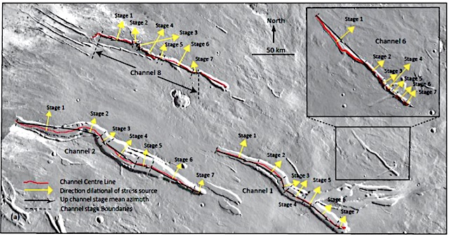
Correlation between graben orientation, channel direction change and tectonic loading: The Elysium Province, Mars

• Graben are systematically arranged around sources of volcanically generated stress, lithospheric loading or regional stress.
• A common sequence of region wide stress events that correlate with graben direction and orientation of channels of differing morphology.
• A development sequence for the NW Elysium Province is proposed using graben orientation and channel direction analysis.

The northwest region of the Elysium Volcanic Province includes volcanoes, large outflow channels and narrow straight valleys called graben. We noticed that some outflow channel shapes matched, and nearly all graben were arranged in lines, curves or clusters.

Analyzing these arrangements we identified a sequence of geological events that could have created the Province. With mapping and analysis we have shown the outflow channel directions, and the location and direction of graben, have been controlled by the same tectonic forces.As events changed in time the force direction also changed, allowing us to identify probable events, for example volcano growth.

We suggest the Province elevation increased as magma rose from the Martian interior; then the Hecates Tholus volcano increased in size; followed by the growth of Elysium Mons, the largest volcano in the Province. We suggest some lava erupted by Elysium Mons flowed away in subsurface channels called dikes to the surrounding Province, creating graben similar to some features seen in the northern Canadian Shield.

These results are important since this is the first time the Province growth events have been measured in this way, and the results are more accurate than some earlier attempts to predict this history. [More at link]

Posted in Reports | Tagged , , , , , | Comments Off

Curiosity update: Dust to dust

2283ML0121470000705221E01_DXXX-br2Sol 2292, January 17, 2019, update by MSL scientists Brittney Cooper and Claire Newman: Today was our last day at “Rock Hall,” so it was our final chance to get every last bit of science at this location. We had a 2.5 hour science block filled with Mastcam change detection imaging of the Rock Hall drill fines and alternating ChemCam RMI and LIBS observations of the Rock Hall dump pile, drill tailings, and target “St. Cyrus 2.” The ChemCam activities were followed by Mastcam documentation images of each of the aforementioned targets, and we also included a B-side computer diagnostic and an overnight APXS of the Rock Hall drill tailings.

Gale Crater has become a lot dustier in recent sols due to a regional dust storm in the southern hemisphere that was spotted by the Mars Climate Sounder team, so we added several extra environmental observations to see how this is affecting the atmosphere. These included extra measurements of the amount of dust above us (with the observation known as the “Mastcam tau”) and of visibility across the crater (with the “Navcam Line of Sight” and “Mastcam Crater Rim Extinction” observations)… [More at link]

Posted in Reports | Tagged , , , , , , , , , , , , , | Comments Off

How do impacts make Mars central-pit craters?

figure-2[Editor’s note: From a paper by Samantha Peel and two co-authors recently published in the Journal of Geophysical Research.]

Formation of central pits in impact craters on Mars: A statistical investigation of proposed mechanisms

• Formation mechanisms for central pits in Mars craters are tested with inferential statistics applied to data from image analyses.
• Published hypothesized mechanisms provide expected observations for comparison to the collected data.
• Results do not support any single previously proposed mechanism but operation of multiple central pit formation mechanisms is possible.

Planetary bodies are hit by large objects such as asteroids and comets. These impacts create large depressions in the planetary surface. Some of these depressions have even smaller depressions, or pits, in their centers.

The formation of these central pits is not well understood, although many ideas have been suggested. Here, we evaluate test a selection of these ideas by comparing the expected appearance of the central pit craters formed by these suggested mechanisms to what we observe in data from Mars.

In this comparison, we have grouped these selected formation mechanisms into three groups: (A) explosive release of water vapor, (B) uplift and collapse of rock at the crater centers, and (C) drainage of liquid, produced by the impact, into cracks in crater floor. The results of our study do not point to central pit formation by any single mechanism assessed here. Instead, multiple processes may be responsible. [More at link]

Posted in Reports | Tagged , , , | Comments Off

THEMIS: Moving downhill

Moving downhill (THEMIS_IOTD_20190118)THEMIS Image of the Day, January 18, 2019. This VIS image shows an isolated mountain east of Hellas Planitia. Erosion is moving material down hill towards the lower elevations.

The linear features on the hill debris indicate that volatiles such as ice may play a part in the erosion. (Sunlight is coming from the left.)

See more THEMIS Images of the Day by geological subject.

Posted in Reports | Tagged , , , , , , , , | Comments Off