


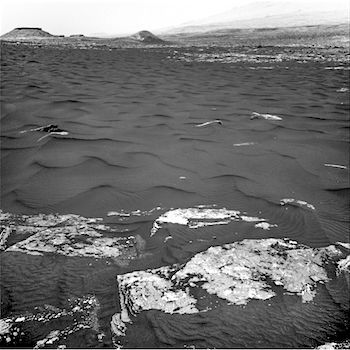
 Sol 1647-49, March 24, 2017, update by USGS scientist Ken Herkenhoff: The traction control test went well, and MSL drove over 30 meters on Sol 1646. The rover will be busy this weekend with lots of remote sensing, arm work, and a drive onto the edge of the dune. On Sol 1647, Left Mastcam will take a 360-degree panorama and Right Mastcam will acquire a 17×3 mosaic of the edge of the sand dune, which was named “Ogunquit Beach.” Then ChemCam and Right Mastcam will observe bedrock targets “Damariscotta Lake,” “Mount Katahdin,” and “Boothbay Harbor.” Late that afternoon, the arm will be unstowed for drill diagnostic tests and a full suite of MAHLI images on another bedrock target dubbed “Halftide Ledge.” APXS will then be placed on the same target for… [More at link]
-
Recent Posts
Tags
Aeolis Mons Arizona State University ASU atmosphere Beautiful Mars Cape Tribulation clouds craters Curiosity dunes dust Endeavour Crater ESA European Space Agency Gale Crater High Resolution Imaging Science Experiment HiRISE Malin Space Science Systems Marathon Valley MARCI Mars Color Imager Mars Exploration Rover Mars Odyssey Mars Reconnaissance Orbiter Mars Science Laboratory mass wasting MER Mount Sharp MRO MSL MSSS Murray Formation NASA Opportunity sand dunes Stimson Formation storms THEMIS THEMIS Image of the Day Thermal Emission Imaging System University of Arizona Vera Rubin Ridge volcanics weather windArchives
Links
general
mission instruments
- CRISM: Compact Reconnaissance Imaging Spectrometer for Mars
- CTX: Context Camera
- HiRISE: High Resolution Imaging Science Experiment
- MARSIS: Mars Advanced Radar for Subsurface and Ionosphere Sounding
- SHARAD: Shallow Radar
- THEMIS: Thermal Emission Imaging System
missions
- All Mars missions list
- Curiosity rover
- ExoMars
- Hope (al-Amal) orbiter
- InSight
- Mars Atmosphere and Volatile Evolution Mission (MAVEN)
- Mars Exploration Rovers (MER)
- Mars Express (MEX)
- Mars Odyssey
- Mars Orbiter Mission (MOM) / Mangalyaan
- Mars Reconnaissance Orbiter (MRO)
- Mars Science Laboratory (MSL)
- Perseverance Rover
- Tianwen-1 orbiter/rover
news