


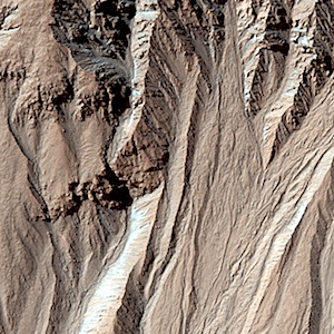
 This image covers a location that has been imaged several times to look for changes in gullies. The cutout shows a comparison between the first HiRISE image of the location and one of the more recent views. A lobate, rubbly flow (noted by the arrows) has been deposited near the mouth of the channel between the time of the two images. Further up the slope, the channel system has been modified by both erosion and deposition. Other images can pin down the timing of this flow more precisely, but it is easier to see… [More at link]
-
Recent Posts
Tags
Aeolis Mons Arizona State University ASU atmosphere Beautiful Mars Cape Tribulation clouds craters Curiosity dunes dust Endeavour Crater ESA European Space Agency Gale Crater High Resolution Imaging Science Experiment HiRISE Malin Space Science Systems Marathon Valley MARCI Mars Color Imager Mars Exploration Rover Mars Odyssey Mars Reconnaissance Orbiter Mars Science Laboratory mass wasting MER Mount Sharp MRO MSL MSSS Murray Formation NASA Opportunity sand dunes Stimson Formation storms THEMIS THEMIS Image of the Day Thermal Emission Imaging System University of Arizona Vera Rubin Ridge volcanics weather windArchives
Links
general
mission instruments
- CRISM: Compact Reconnaissance Imaging Spectrometer for Mars
- CTX: Context Camera
- HiRISE: High Resolution Imaging Science Experiment
- MARSIS: Mars Advanced Radar for Subsurface and Ionosphere Sounding
- SHARAD: Shallow Radar
- THEMIS: Thermal Emission Imaging System
missions
- All Mars missions list
- Curiosity rover
- ExoMars
- Hope (al-Amal) orbiter
- InSight
- Mars Atmosphere and Volatile Evolution Mission (MAVEN)
- Mars Exploration Rovers (MER)
- Mars Express (MEX)
- Mars Odyssey
- Mars Orbiter Mission (MOM) / Mangalyaan
- Mars Reconnaissance Orbiter (MRO)
- Mars Science Laboratory (MSL)
- Perseverance Rover
- Tianwen-1 orbiter/rover
news