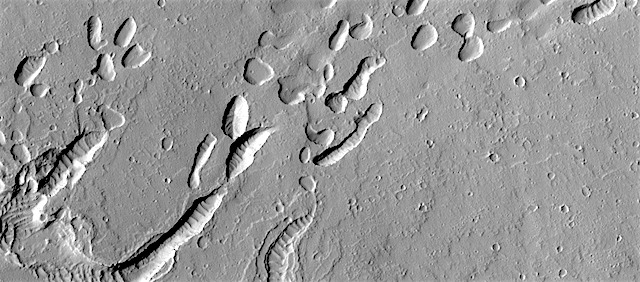
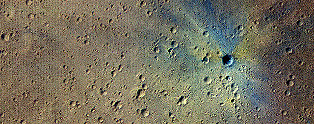
MRO keeps finding new impact sites on Mars. This one occurred within the dense secondary crater field of Corinto Crater, to the north-northeast.
The new crater and its ejecta have distinctive color patterns. Once the colors have faded in a few decades, this new crater will still be distinctive compared to the secondaries by having a deeper cavity compared to its diameter. [More at link]
An international team of scientists has created a tiny chemistry lab for a rover that will drill beneath the Martian surface looking for signs of past or present life. The toaster oven-sized lab, called the Mars Organic Molecule Analyzer or MOMA, is a key instrument on the ExoMars Rover, a joint mission between the European Space Agency and the Russian space agency Roscosmos, with a significant contribution to MOMA from NASA. It will be launched toward the Red Planet in July 2020.
“The ExoMars Rover’s two-meter deep drill will provide MOMA with unique samples that may contain complex organic compounds preserved from an ancient era, when life might have gotten started on Mars,” said MOMA Project Scientist Will Brinckerhoff of NASA’s Goddard Space Flight Center in Greenbelt, Maryland. (…)
The MOMA instrument will be capable of detecting a wide variety of organic molecules. Organic compounds are commonly associated with life, although they can be created by non-biological processes as well. Organic molecules contain carbon and hydrogen, and can include oxygen, nitrogen, and other elements. To find these molecules on Mars, the MOMA team had to take instruments that would normally occupy a couple of workbenches in a chemistry lab and shrink them down to roughly the size of a toaster oven so they would be practical to install on a rover… [More at link]
THEMIS Image of the Day, May 29, 2018. This VIS image is located on the margin of the Nili Fossae region and Isidis Planitia. At the bottom of the image a channel feature is visible, the branch on the right appears to empty into the surface at the top of the image. The branch to the left does not reach the top of the image, so it is likely flowing from the upper left into the bottom channel. The 90 degree bends of this large channel feature indicated that tectonic forces are affecting the features formed in this region.
This is further supported by the series of very small orthogonal ridges just north of the center of the image. These small ridges probably were formed in a multi part process. First tectonic activity created fractures in a preexisting rock, then a new material filled the fractures, finally erosion of the host rock occurred, removing the original materials and leaving just the fracture fill.
Both the large and small scale features in this region point to a long period of tectonic activity in this region.
THEMIS Image of the Day, May 28, 2018. This VIS image shows part of the margin of the north polar cap and the surrounding plains. The layering of the ice is easily visible due to the dust that is deposited on the top of the ice every year, creating layering over millions of years.
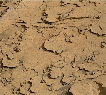
Sols 2063-66, May 25, 2018, update by MSL scientist Ken Herkenhoff: Some of the Duluth drill sample was dropped into CheMin on Sol 2061, but not enough for a proper mineralogical analysis. So the top priority for today’s plan is to again test the new drop-off procedure. Since the drill feed mechanism became unreliable over a year ago, drill samples can no longer be sieved and processed in CHIMRA, as they were earlier in the mission. Instead, portions of the sample must be dropped from the tip of the drill directly into the analytical instruments. This new Feed-Extended Sample Transfer (FEST) procedure will be repeated on Sol 2064, over bedrock and over the closed SAM inlet cover. Mastcam images will be taken both before and after the drop-off in both locations, to allow the size of the sample portion to be estimated. The results of these tests will be used to inform future drop-off planning.
We’re planning 4 sols today so that the tactical operations team can take a day off for the Memorial Day holiday… [More at link]
What’s the latest news from Mars? NASA’s InSight lander and MarCO CubeSats are on their way to the Red Planet, a tiny helicopter will hitch a ride with the Mars 2020 rover mission, and Curiosity’s drill is back in business! [More at link]
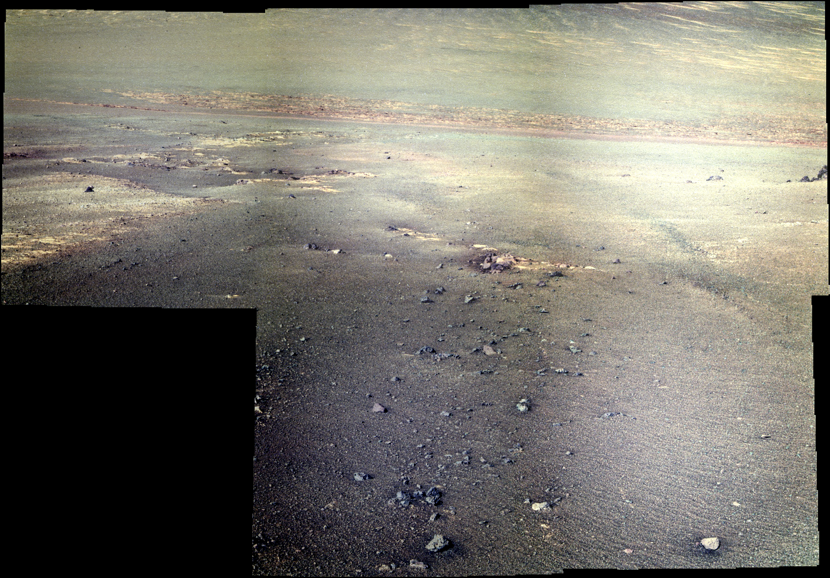
Sol 5094, May 24, 2018. Opportunity’s Pancam looked downslope and made a set of multi-filtered images (false-color by Holger Isenberg) for a composite view of the lower Perseverance Valley channel. Note the streaks in the soil in the two images nearest the rover.
At right is a view of soil disturbed by the rover’s wheel. (A similar view on Sol 5087 is here.) Click either image to enlarge it.
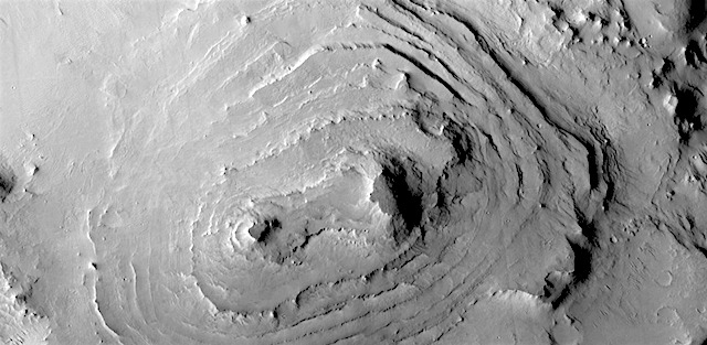
Stair-stepped hill in central Arabia Terra. Stratified material eroded so as to look something like a wedding cake. A cliff-bench slope expression, apparently mantled with dust, each layer is roughly the same thickness as the next.
THEMIS Image of the Day, May 25, 2018. This VIS image shows part of Olympia Undae, a large dune field that surrounds part of the north polar cap. At the top of the image the dunes are small and isolated.
As the amount of available sand increases the density of dunes increases. This is seen at the bottom of the image. Collected during northern summer, the dunes are completely free of ice and frost.


 MRO keeps finding new impact sites on Mars. This one occurred within the dense secondary crater field of Corinto Crater, to the north-northeast.