Opportunity: Scoping the slope

5074-navcam
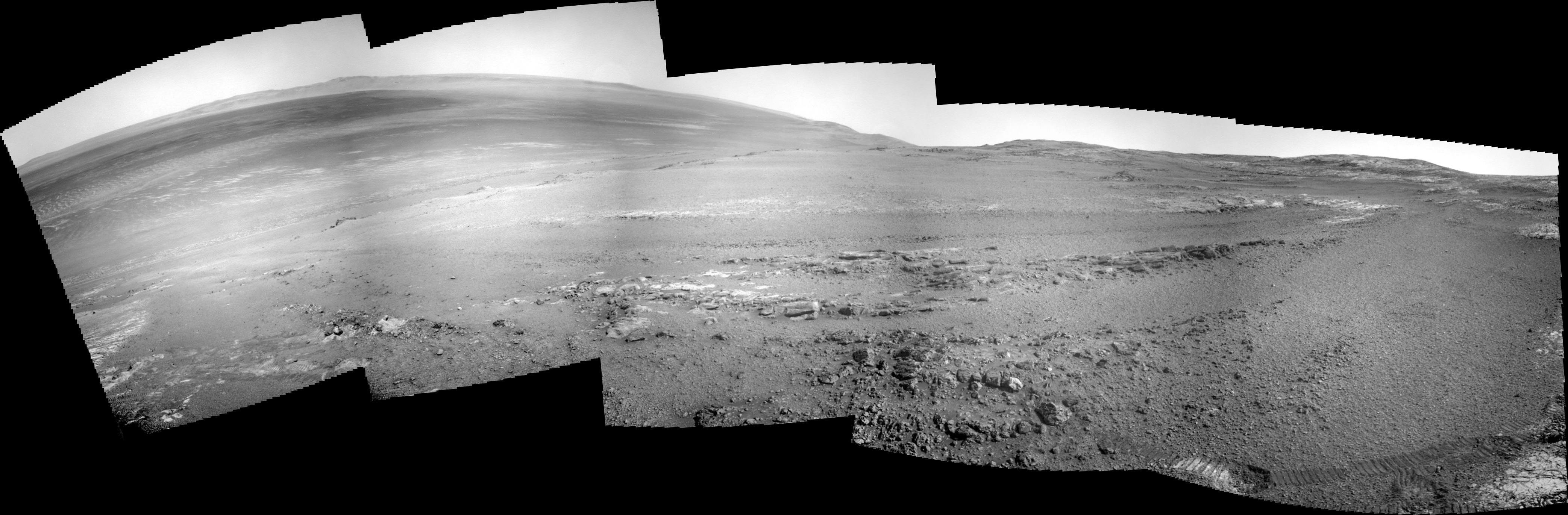
Sol 5074, May 3, 2018. Opportunity has shifted its location a little, moving upslope almost 2 meters (6 feet), as mission scientists work to explore what geological processes created Perseverance Valley. The Navcam composite above ranges from downslope to the east (left side) to upslope to the west (right side). Click image to enlarge it.

Opportunity raw images, its latest mission status, location map, and atmospheric opacity, known as tau.

Posted in Reports | Tagged , , , , , , , , | Comments Off

ESA deep-space tracking ready for InSight

Over_the_rainbowNASA’s latest mission to Mars begins tomorrow. ESA deep space ground stations in Australia and South America will track the InSight spacecraft on NASA’s behalf as it begins its cruise to the Red Planet.

Set to be launched from Vandenburg Air Force Base in California on an Atlas V at 1105 UTC (1305 CEST) on Saturday, InSight will bring a lander to Mars to study its interior, with equipment to measure internal heat and detect ‘marsquakes’. InSight’s 485-million km journey to Mars will take about six months, beginning soon after it separates from its launcher in Earth orbit.

Five hours after launch, ESA’s deep space ground station at New Norcia in Western Australia, will pick up the signal from InSight. It will maintain contact as a ‘hot backup’ at the same time as NASA’s own Deep Space Network ground station at Canberra, over on the easterly side of the continent.

Once Canberra loses contact, the 35-m dish antenna at New Norcia will maintain contact with the mission until it vanishes under the horizon. ESA’s second southern-hemisphere deep space ground station at Malargüe in Argentina will pick up the contact two and a half hours after that.

“Our stations at New Norcia and Malargüe will allow NASA to keep in touch with InSight during its critically important ‘launch and early operations’ phase, when the spacecraft systems are first turned on and checked,” explains Daniel Firre, the Agency’s ESA-NASA cross-support service manager. [More at link]

Posted in Reports | Tagged , , , , , , | Comments Off

Curiosity update: Mmmmmm…..science

NLB_578604801EDR_F0700886CCAM04040M_-br2Sol 2041, May 3, 2018, update by MSL scientist Michelle Minitti: Curiosity continued her journey off of the “Vera Rubin Ridge,” driving west along the ridge flank toward a passable route down to the bedrock north of the ridge. Her stop today may have been brief, but it was ehhhhhhxcellent. ChemCam will acquire ten spot rasters across “Homer Lake,” a finely-layered bedrock block, and “Barto Lake,” white sulfate vein material pasted to the side of the Homer Lake block. After ChemCam shoots Homer Lake and Barto Lake, Mastcam will collect multispectral data from both targets, giving Mastcam a view of the areas cleared of dust by the laser and providing complementary data to the ChemCam analyses. Mastcam will feel at home imaging “Terrace Point,” a set of bedrock blocks with distinctive surface textures. Navcam will search for dust devils both…. [More at link]

Posted in Reports | Tagged , , , , , , , , , , , | Comments Off

MAVEN: Deep-dip campaign #9 completed

31870517_10156584176252868_719079762751913984_nMAVEN has successfully completed the 9th deep dip campaign of the mission.

Two walk-out maneuvers were performed to raise the periapsis (closest approach to Mars) of the spacecraft by 33 km:

● The first maneuver was performed on May 1. It required a ∆V of 2.4 m/sec., which raised MAVEN’s periapsis by 14.7 km and placed the spacecraft into a corridor where Mars’ atmospheric density is ~0.55 kg/km³.

● The second maneuver was performed on May 2. It required a ∆V of 3.0 m.sec., which raised MAVEN’s periapsis by another 18.4 km and placed the spacecraft into the middle of the nominal science-mapping corridor where Mars’ atmospheric density is between 0.05 kg/km³ and 0.15 kg/km³.

Currently (as of Thursday, May 3, 2018), MAVEN’s estimated mean periapsis density is 0.10 kg/km³ at a mean periapsis altitude of 158.5 km. MAVEN’s orbital period is 4 hours and 23 minutes. [More at link]

Posted in Reports | Tagged , , , | Comments Off

InSight: Pre-launch briefing videocast

InSight, the first planetary mission to take off from the West Coast, is targeted to launch at 4:05 a.m. PDT (7:05 a.m. EDT) on May 5 from Space Launch Complex-3 at Vandenberg Air Force Base (VAFB) in California, aboard a United Launch Alliance (ULA) Atlas V rocket.

The agency hosted a prelaunch briefing on May 3 at VAFB. Presenters included:

• Jim Green, NASA chief scientist
•Tom Hoffman, InSight project manager at JPL
• Stu Spath, InSight program manager at Lockheed Martin Space, Denver
• Bruce Banerdt, InSight principal investigator at NASA’s Jet Propulsion Laboratory, Pasadena, California
• Annick Sylvestre-Baron, deputy project manager for InSight seismometer investigation at France’s space agency, the Centre National d’Études Spatiales, Paris
• Philippe Lognonné, InSight seismometer investigation lead at the Institut de Physique du Globe de Paris, France
• Tilman Spohn, investigation lead at the German Aerospace Center (DLR) for the Heat Flow and Physical Properties Probe (HP3), an instrument on InSight, Berlin
• Andrew Klesh, MarCO chief engineer at JPL
• Anne Marinan, MarCO systems engineer at JPL
• Tim Dunn, launch director with NASA’s Launch Services Program at Kennedy Space Center, Florida
• Scott Messer, ULA program manager for NASA launches, Centennial, Colorado
• Col. Michael Hough, commander of the 30th Space Wing at Vandenberg Air Force Base, Central California
• 1st Lt. Kristina Williams, weather officer for the 30th Space Wing [More at link]

Posted in Reports | Tagged , , , , , , , , , , , , , , , | Comments Off

HiRISE: Central peak and pit with bedrock exposures

tumblr_p7rfmvwG9l1rlz4gso3_1280A central peak and pit with bedrock exposures. Beautiful Mars series. [More at links]

Posted in Reports | Tagged , , , , , , , , , | Comments Off

THEMIS: Mantling on Terra Sabaea channel

Terra Sabaea channel (THEMIS_IOTD_20180504)THEMIS Image of the Day, May 4, 2018. This VIS image shows one of the numerous unnamed channels in northern Terra Sabaea. The softened features in the image suggest that some kind of mantling material lies over much of the landscape in this part of Mars.

More THEMIS Images of the Day by geological topic.

Posted in Reports | Tagged , , , , , , , , , | Comments Off

InSight is on track for Saturday launch

PIA22227-16All systems are go for NASA’s next launch to the Red Planet.

The early-morning liftoff on Saturday of the Mars InSight lander will mark the first time in history an interplanetary launch will originate from the West Coast. InSight will launch from the U.S. Air Force Vandenberg Air Force Base Space Launch Complex 3E. The two-hour launch window will open on May 5 at 4:05 a.m. PDT (7:05 a.m. EDT).

InSight, for Interior Exploration using Seismic Investigations, Geodesy and Heat Transport, will launch aboard a United Launch Alliance (ULA) Atlas V rocket. InSight will study the deep interior of Mars to learn how all rocky planets formed, including Earth and its Moon. The lander’s instruments include a seismometer to detect marsquakes, and a probe that will monitor the flow of heat from the planet’s interior.

The ULA rocket will carry the spacecraft over the Channel Islands just off the California Coast and continue climbing out over the Pacific, shadowing the coastline south beyond Baja California. InSight’s Atlas will reach orbit about 13 minutes after launch, when the rocket is about 1,200 miles (1,900 kilometers) northwest of Isabella Island, Ecuador.

“For those Southern Californians who are interested in rockets or space exploration, or have insomnia, we hope to put on a great show this Saturday,” said Tom Hoffman, InSight project manager from NASA’s Jet Propulsion Laboratory in Pasadena, California. “But for those who want to sleep in on Saturday, there will be another opportunity to engage with this historic mission. We will be landing on Mars in the western Elysium Planitia region on Monday, Nov. 26, around noon Pacific time. You will be able to watch a live stream of this landing while working on your holiday shopping.” [More at link]

Posted in Reports | Tagged , , , , | Comments Off

Curiosity update: Go west, young rover

NLB_578509114EDR_F0700552NCAM00298M_-br2Sol 2040, May 3, 2018, update by MSL scientist Ryan Anderson: Our drive from Sol 2039 was successful, and the plan for sol 2040 is to continue driving to the west. Before we do that, ChemCam will analyze the bedrock target “Prairie Lake” and the loose rock “Gowan”. Mastcam will take a single image to document both targets, as well as an image of the autonomously-selected target observed after the sol 2039 drive. Mastcam also has a 9-frame mosaic of an interesting crack in the soil near the rover. The targeted science block will wrap up with a Navcam movie to watch for clouds over Mt. Sharp. After the drive, in addition… [More at link]

Posted in Reports | Tagged , , , , , , , , , , | Comments Off

Finding martian fossils: A field guide

figure-1This paper [A Field Guide to Finding Fossils on Mars, by S. McMahon, T. Bosak, J. P. Grotzinger, R. E. Milliken, R. E. Summons, M. Daye, S. A. Newman, A. Fraeman, K. H. Williford, D. E. G. Briggs, Journal of Geophysical Research – Planets] reviews the rocks and minerals on Mars that could potentially host fossils or other signs of ancient life preserved since Mars was warmer and wetter billions of years ago.

We apply recent results from the study of Earth’s fossil record and fossilization processes, and from the geological exploration of Mars by rovers and orbiters, in order to select the most favoured targets for astrobiological missions to Mars.

We conclude that mudstones rich in silica and iron‐bearing clays currently offer the best hope of finding fossils on Mars and should be prioritized, but that several other options warrant further research. We also recommend further experimental work on how fossilization processes operate under conditions analogous to early Mars. [More at link]

Posted in Reports | Tagged , , | Comments Off