


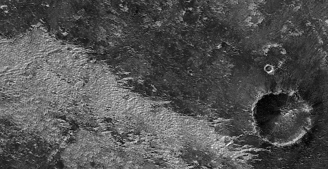
 Contact between an older shield volcano and younger flows. Interested in the geologic contact here between the older shield volcano and the younger flows that enclose it.
Beautiful Mars series. [More at links]
Contact between an older shield volcano and younger flows. Interested in the geologic contact here between the older shield volcano and the younger flows that enclose it.
Beautiful Mars series. [More at links]
 THEMIS Image of the Day, April 27, 2018. Today’s VIS image shows a section of Bahram Vallis. This channel is located in northern Lunae Planum, south of Kasei Valles.
More THEMIS Images of the Day by geological topic.
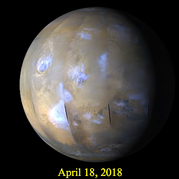 A regional dust storm kicked up in the southern mid-to-low latitudes of Promethei-Cimmeria this past week. Dust lofted by the storm was transported eastward as far as western Noachis. Additional local storm activity was observed in Hellas Basin, as well as coming south over the northern plains from perennial north polar cap edge. Afternoon condensate ice clouds continued to be observed over all the major shield volcanoes across the… [More at link, including video]
 Sols 2034-35, April 25, 2018, update by MSL scientist Mark Salvatore: Curiosity is continuing her march to the north and west, descending through the stratigraphic layers exposed in Vera Rubin Ridge and working her way back towards the unit known as the Blunts Point member, just below the ridge. Curiosity will continue her investigation of each of these stratigraphic layers, filling in all of the details necessary to interpret the geologic history of this region.
Until then, the science team is keeping Curiosity busy with additional measurements to better interpret the local and regional geology. In today’s two-sol plan, Curiosity will begin with a 1 hour and 40 minute science block dedicated to studying the exposed rocky material in front of the rover. The science block kicks off with ChemCam measurements of surface chemistry using the onboard laser and spectrometers. The targets include “Mesabi,” a textured rock towards the left-front wheel, then “Wakemup Bay,” which appears to be in-place bedrock, and finally “Midway,” a long and narrow rock in front of the rover that has potentially been broken apart by the small impact crater (named “Taconite crater”), to the north of… [More at link]
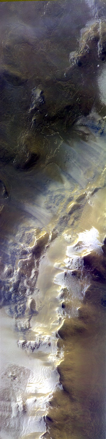 The ExoMars Trace Gas Orbiter has returned the first images of the Red Planet from its new orbit. The spacecraft arrived in a near-circular 400 km altitude orbit a few weeks ago ahead of its primary goal to seek out gases that may be linked to active geological or biological activity on Mars.
The orbiter’s Colour and Stereo Surface Imaging System, CaSSIS, took this stunning image, which features part of an impact crater, during the instrument’s test period. The camera was activated on 20 March and was tested for the start of its main mission, on 28 April.
“We transmitted new software to the instrument at the start of the test phase and after a couple of minor issues, the instrument is in good health and ready to work,” says the camera’s principal investigator, Nicolas Thomas from the University of Bern in Switzerland.
The image captures a 40 km-long segment of Korolev Crater located high in the northern hemisphere. The bright material on the rim of the crater is ice.
“We were really pleased to see how good this picture was given the lighting conditions,” says Antoine Pommerol, a member of the CaSSIS science team working on the calibration of the data. “It shows that CaSSIS can make a major contribution to studies of the carbon dioxide and water cycles on Mars.”
The image is assembled from three images in different colours that were taken almost simultaneously on 15 April.
“We aim to fully automate the image production process,” says Nick. “Once we achieve this, we can distribute the data quickly to the science community for analysis.” [More at link]
 Slopin’ around. We’ve imaged recurring slope lineae in this area, but with a twist: the RSL here are east- and northeast-facing, which makes them more unique as there actually aren’t that many east-facing RSL anywhere on the planet. Plus, the bedrock is also delightful to view.
Beautiful Mars series. [More at links]
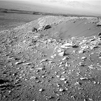
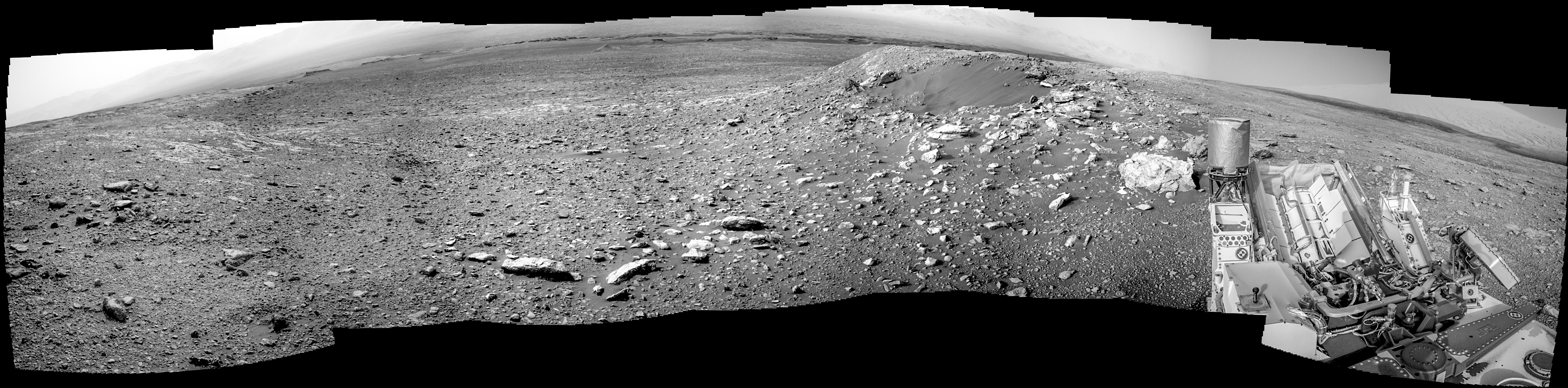 Sol 2032, April 25, 2018. This composite of eight Navcam frames looks toward the north and shows, at right center, sand-filled Taconite Crater, a small impact scar. In the distance below the ridge lie the flat-topped Murray Buttes and the dark skein of the Bagnold Dunes. Click the image to enlarge it.
Sol 2032 raw images (from all cameras), and Curiosity’s latest location.
ESA and NASA signed a statement of intent today [April 26] to explore concepts for missions to bring samples of martian soil to Earth.
Spacecraft in orbit and on Mars’s surface have made many exciting discoveries, transforming our understanding of the planet and unveiling clues to the formation of our Solar System, as well as helping us understand our home planet. The next step is to bring samples to Earth for detailed analysis in sophisticated laboratories where results can be verified independently and samples can be reanalysed as laboratory techniques continue to improve.
Bringing Mars to Earth is no simple undertaking—it would require at least three missions from Earth and one never-been-done-before rocket launch from Mars.
A first mission, NASA’s 2020 Mars Rover, is set to collect surface samples in pen-sized canisters as it explores the Red Planet. Up to 31 canisters will be filled and readied for a later pickup – geocaching gone interplanetary.
In the same period, ESA’s ExoMars rover, which is also set to land on Mars in 2021, will be drilling up to two meters below the surface to search for evidence of life.
A second mission with a small fetch rover would land nearby and retrieve the samples in a martian search-and-rescue operation. This rover would bring the samples back to its lander and place them in a Mars Ascent Vehicle – a small rocket to launch the football-sized container into Mars orbit.
A third launch from Earth would provide a spacecraft sent to orbit Mars and rendezvous with the sample containers. Once the samples are safely collected and loaded into an Earth entry vehicle, the spacecraft would return to Earth, release the vehicle to land in the United States, where the samples will be retrieved and placed in quarantine for detailed analysis by a team of international scientists. [More at link]
 THEMIS Image of the Day, April 26, 2018. Today’s VIS image shows the western rim of Bamberg Crater. The complex nature of the rim is one indication of the relative youth of this crater in relation to it’s surrounding. Many gullies dissect this rim.
More THEMIS Images of the Day by geological topic.
 Spider formations in crater. Of course, these aren’t actual spiders, but that’s the name we give to these formations, called “araneiform.” The spiders here would be very unusual at northern latitudes. Seasonal series of pictures will allow us to compare processes extant here at a location with permanent ice.
Beautiful Mars series. [More at links]