THEMIS: Softly rounded hills in Phlegra Montes

Arcadia's rounded hills (THEMIS_IOTD_20180425)THEMIS Image of the Day, April 25, 2018. The rounded hills in this VIS image are located in Arcadia Planitia. Broad linear ridges and groups of hills in this region are part of Phlegra Dorsa (ridges) and Phlegra Montes (hills). The smooth shapes suggest they are covered in an ice-rich mantle

More THEMIS Images of the Day by geological topic.

Posted in Reports | Tagged , , , , , , , , , | Comments Off

HiRISE: Gullies and flow in a small crater north of Newton Crater

tumblr_p7ccod0HZf1rlz4gso1_1280Gullies and flow in a small crater north of Newton Crater. The objective of this observation is to examine a small crater with gullies and an advanced degree of flow across the crater floor, as well as over an eroded rim. The crater is on a ridge that seems to be the erosional remnant of a larger crater.

Beautiful Mars series. [More at links]

Posted in Reports | Tagged , , , , , , , , , , | Comments Off

Opportunity: Surveying a field of interest

5064-navcamSol 5064, April 23, 2018. The rover’s Navcam shot a composite of four images looking over a nearby area of interest to mission scientists as they seek to determine the origin of the rocks on display here. In the foreground are vesicular rocks, while tabular rocks lie just beyond. What relation, if any, do they have with each other? The view at left looks to the south. Click the image to enlarge it.

Opportunity raw images, its latest mission status, location map, and atmospheric opacity, known as tau.

Posted in Reports | Tagged , , , , , , , | Comments Off

Curiosity update: The rocks vs. stone cold aluminum wheels

2030MH0002640000801521E01_DXXX-br2
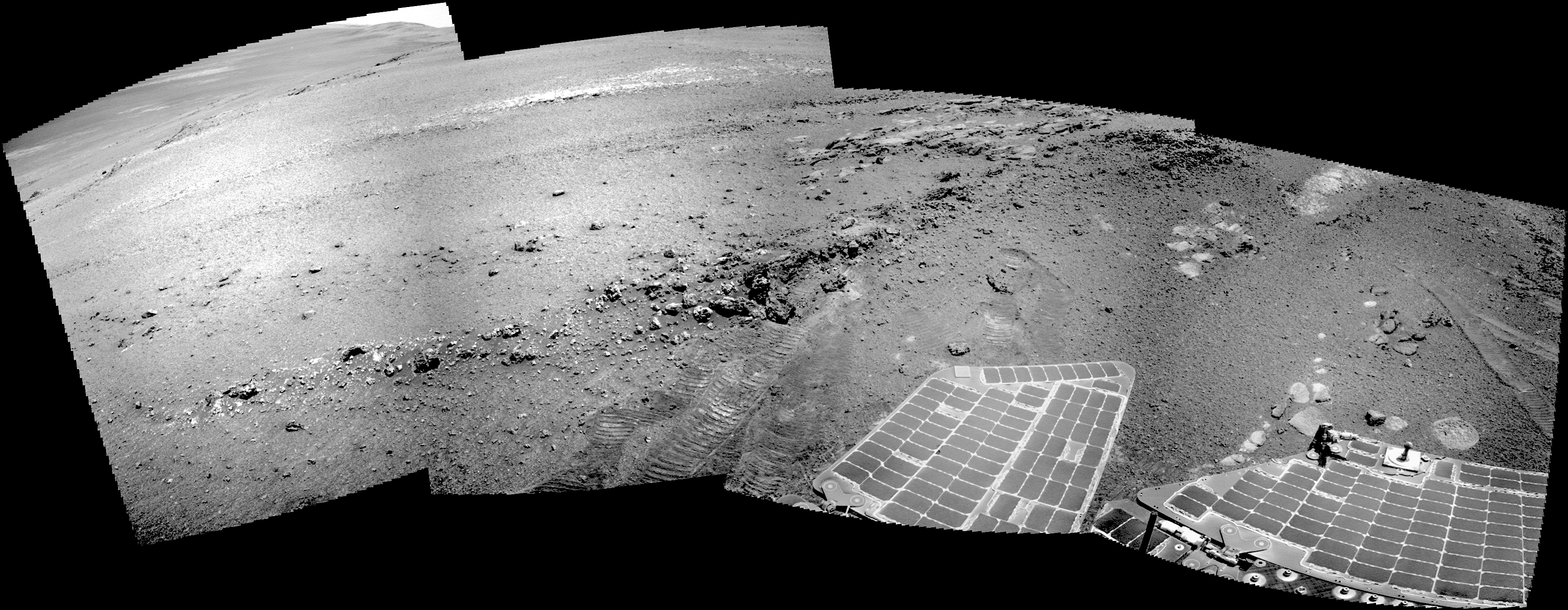
Sols 2032-33, April 23, 2018, update by MSL scientist Abigail Fraeman: Curiosity drove a little over 16 m to the west this weekend. The rover is currently skirting around the southern edge of a small, blocky impact crater on its way north off the Vera Rubin Ridge.

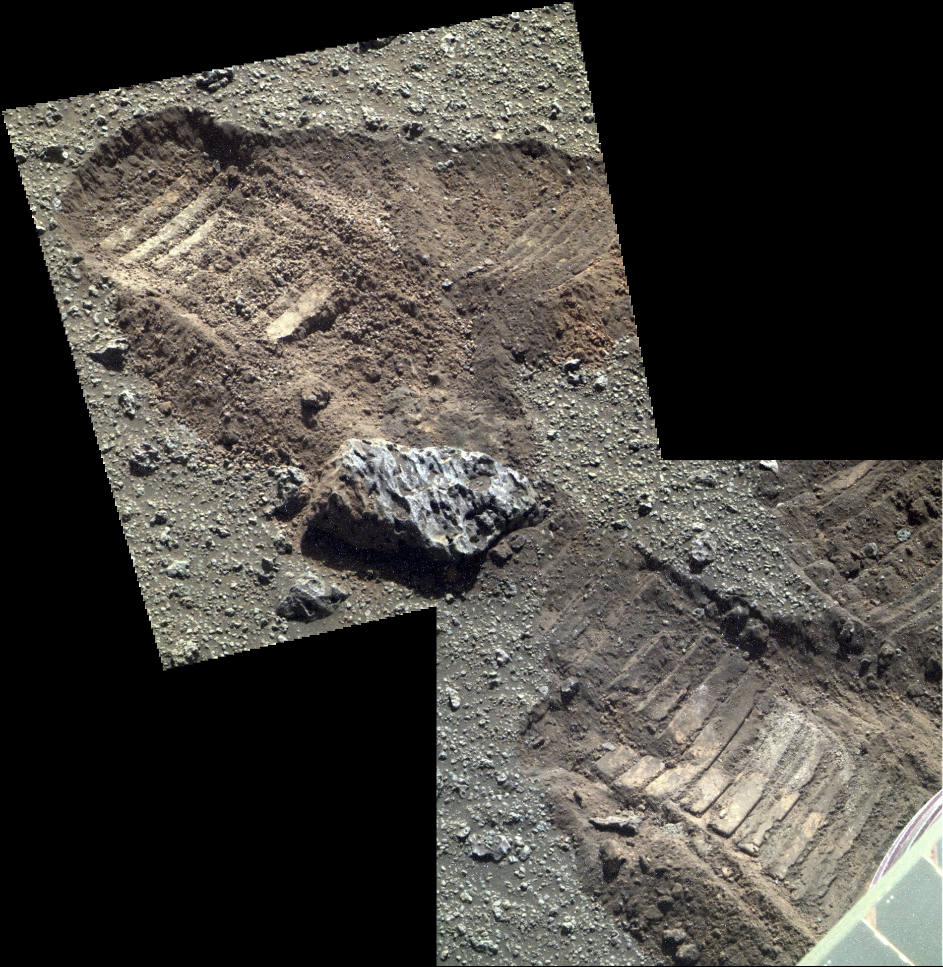
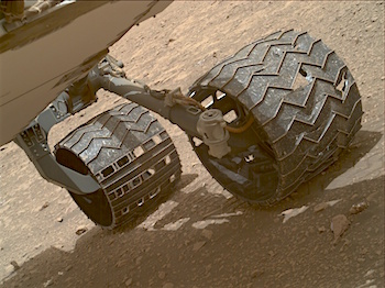
One of the activities we did this weekend was use MAHLI to take images of the rover wheels. We do this activity, dubbed Full MAHLI Wheel Imaging (or FMWI in NASA acronym speak), every few hundred meters to track damage to Curiosity’s wheels caused by the terrain. It’s important for us to take this observation in order to estimate how much farther the rover will be able to drive before the wheels become inoperable, and also to understand if the sharp edges of the broken wheels risk damaging the nearby cables. So far, we estimate we’re in pretty great shape for our plans to drive a lot farther up Mt. Sharp!

For the last few years, we’ve been actively working to mitigate wheel damage in several ways. JPL engineers developed some smart driving algorithms called “traction control” that reduce forces on Curiosity’s wheels as the rover climb over rocks. Geologists like myself also help by planning drive paths over terrain that is safer for the wheels. We do this on a sol-to-sol basis in tactically staffed roles known as Surface Properties Scientist (SPS)… [More at link]
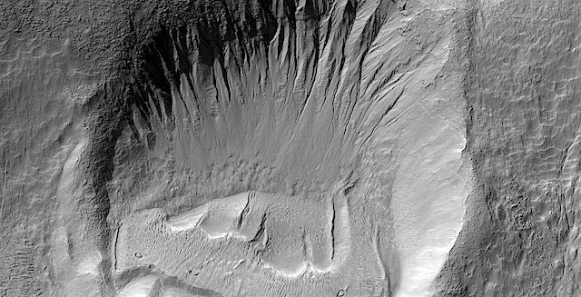
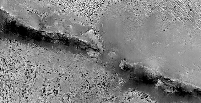
Posted in Reports | Tagged , , , , , , , , , , , , , , , , | Comments Off

HiRISE: Alluvial fans in NE Mojave Crater

tumblr_p7auynVVKU1rlz4gso1_1280Alluvial fans in northeastern Mojave Crater. Mojave Crater is a perennial favorite of ours for the clear signs of these alluvial fans that might indicate it once rained on Mars a very long time ago.

Beautiful Mars series. [More at links]

Posted in Reports | Tagged , , , , , , , , , | Comments Off

THEMIS: Channel deposits in Terra Sabaea

No-name channel in Terra Sabaea (THEMIS_IOTD_20180424)THEMIS Image of the Day, April 24, 2018. The northern margins of Arabia Terra and Terra Sabaea contain many unnamed channels. This channel is located in Terra Sabaea. The channel flow is toward the top of the image. This channel has been covered by craters at the top of the image, showing that the channel flow occurred prior to the impacts that created the craters.

More THEMIS Images of the Day by geological topic.

Posted in Reports | Tagged , , , , , , , , , | Comments Off

Opportunity: Pancam, far and near

5062-pancamFC-farSol 5062, April 21, 2018. Opportunity turned the Pancam on a nearby patch of ground disturbed by the right-side wheels and also took a look at the tabular outcrop a little distance away.  (False-color reconstructions by Holger Isenberg.)  Click either image to enlarge it.

Opportunity raw images, its latest mission status, location map, and atmospheric opacity, known as tau.

5062-pancamFC-near

Posted in Reports | Tagged , , , , , , , | Comments Off

HiRISE: Possible landing site for ExoMars rover in Mawrth Vallis

tumblr_p7hw24NzwK1rlz4gso1_1280A possible landing site for the ExoMars rover in Mawrth Vallis. This digital terrain model (DTM) covers part of the proposed landing site for the European Space Agency’s ExoMars Rover at Mawrth Vallis. The proposed landing site is on the southern margins of the main Mawrth Vallis channel and southeast of the proposed Mars Science Laboratory landing site.

This cutout shows the DTM overlaid on a HiRISE image. The DTM has been used to determine topographic information that would allow the rover to land safely.

At Mawrth Vallis, dark-toned material, possible volcanic ash beds or lava flows, lies on top of light-toned material. The light-toned material is considered a prime target for the rover, as this material is rich in clay minerals, which likely formed due to alteration by water billions of years ago.

Beautiful Mars series. [More at links]

Posted in Reports | Tagged , , , , , , , , , , , , , , | Comments Off

Curiosity update: Booking it through Biwabik

Curiosity_Location_Sol2027-full2Sols 2029-31, April 20, 2018, update by MSL scientist Abigail Fraeman: Curiosity drove a whopping ~85 m to the northwest in the sol 2027 plan. Besides being long, this drive was remarkable because it marked a shift in Curiosity’s strategic campaign: we have officially finished our initial reconnaissance of Vera Rubin Ridge, and we are beginning our journey down off the ridge, heading north into an area where we would like to test the rover’s drill. The guidance from the team is now “drive, drive, drive!,” while still doing as much opportunistic science as we can along the way of course.

With the sol 2027 drive, we have also officially entered the Biwabik Quad. You may recall we flirted with the boundary of this quad back on sol 2004-2007 and 2009-2012. Biwabik is a city in the United States in northern Minnesota that is connected with the Mesabi Range. This range contains a vast iron deposit, so we felt it was a perfect choice for the hematite-rich area we are currently exploring. (Hematite is an iron-rich mineral). Entering a… [More at link]

Posted in Reports | Tagged , , , , , , , , , , , , , | Comments Off

HiRISE: The Martian Horns of Hattin?

tumblr_p7cal8UPuJ1rlz4gso1_1280The Martian Horns of Hattin? No, it’s actually a degraded crater rim, and this is similar to what Opportunity viewed at Endeavour Crater.

Beautiful Mars series. [More at links]

Posted in Reports | Tagged , , , , , , , , , | Comments Off