THEMIS: Collapsed lava tubes on Pavonis Mons

Collapsed lava tubes on Pavonis Mons (THEMIS_IOTD_20171030)
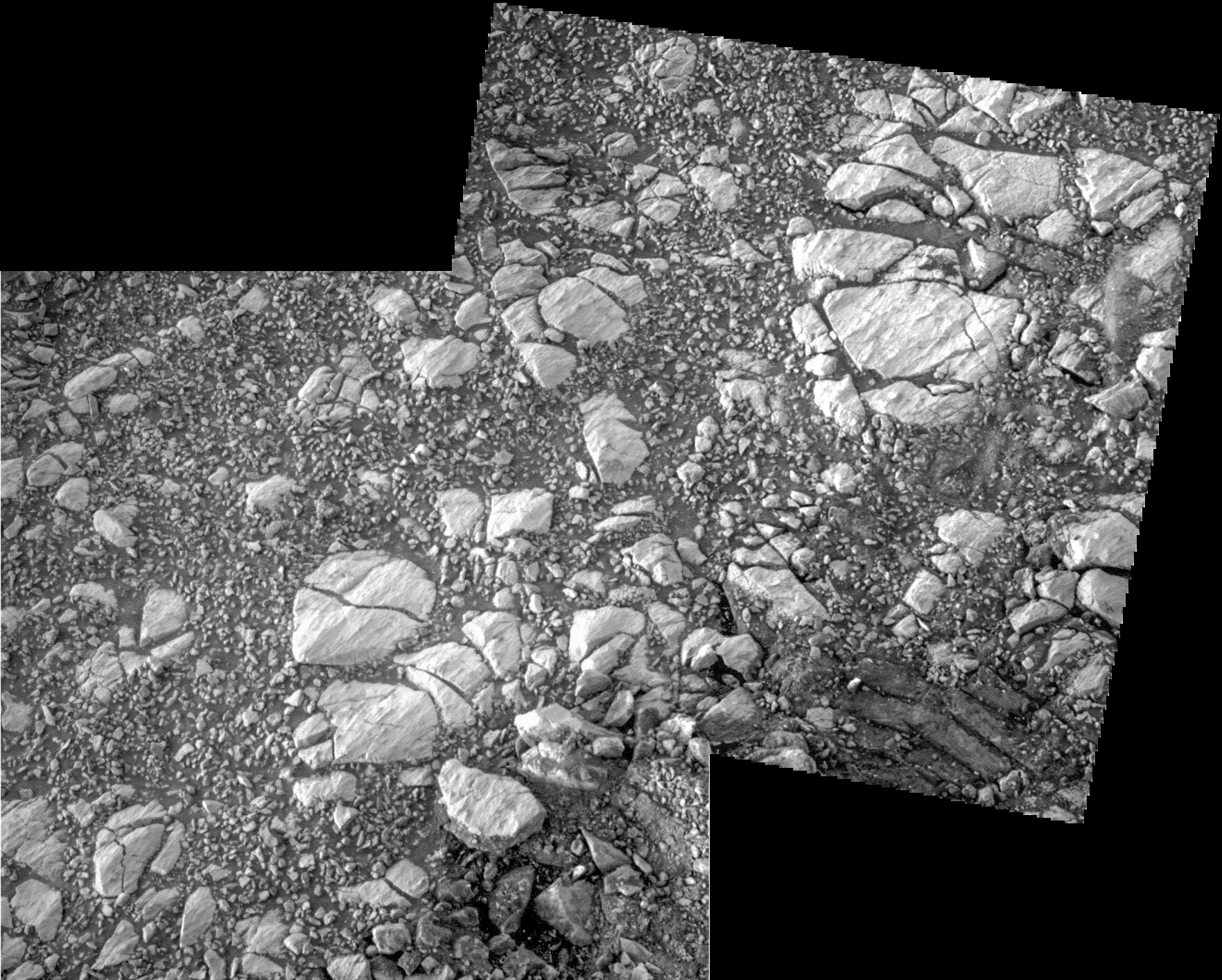
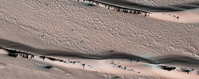
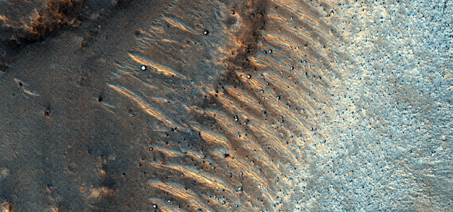
THEMIS Image of the Day, October 30, 2017. This image shows part of the southern flank of Pavonis Mons. The linear and sinuous features mark the locations of lava tubes and graben that occur on both sides of the volcano along a regional trend that passes thru Pavonis Mons, Ascreaus Mons (to the north), and Arsia Mons (to the south). The majority of the features are believed to be lava tubes where the ceiling has collapsed into the free space below. This often happens starting in a circular pit and then expanding along length of the tube until the entire ceiling of material has collapsed into the bottom of the tube.

Pavonis Mons is one of the three aligned Tharsis Volcanoes. The four Tharsis volcanoes are Ascreaus Mons, Pavonis Mons, Arsia Mons, and Olympus Mars. All four are shield type volcanoes. Shield volcanoes are formed by lava flows originating near or at the summit, building up layers upon layers of lava. The Hawaiian islands on Earth are shield volcanoes. The three aligned volcanoes are located along a topographic rise in the Tharsis region. Along this trend there are increased tectonic features and additional lava flows.

Pavonis Mons is the smallest of the four volcanoes, rising 14 km above the mean Mars surface level with a width of 375 km. It has a complex summit caldera, with the smallest caldera deeper than the larger caldera. Like most shield volcanoes the surface has a low profile. In the case of Pavonis Mons the average slope is only 4 degrees.

NASA’s Mars Odyssey spacecraft has spent over 15 years in orbit around Mars, circling the planet more than 69,000 times. It holds the record for longest working spacecraft at Mars. THEMIS, the IR/VIS camera system, has collected data for the entire mission and provides images covering all seasons and lighting conditions.

Over the years many features of interest have received repeated imaging, building up a suite of images covering the entire feature. From the deepest chasma to the tallest volcano, individual dunes inside craters and dune fields that encircle the north pole, channels carved by water and lava, and a variety of other feature, THEMIS has imaged them all.

For the next several months the Image of the Day will focus on the Tharsis volcanoes, the various chasmata of Valles Marineris, and the major dunes fields. We hope you enjoy these images!

More THEMIS Images of the Day by geological topic.

Posted in Reports | Tagged , , , , , , , , , , , , | Comments Off

Opportunity: Looking at La Bajada

4891-pancam-la-bajadaSol 4891, October 27, 2017. Opportunity’s current target of study is a rocky area dubbed La Bajada. The Pancam shot a two-frame composite showing the surface of the rocks partly embedded in the soil. The rocks show shallow grooves that are largely aligned and possibly etched by the wind. (Rover wheel tracks are visible at lower right.) Click the image to enlarge it.

Opportunity raw images, its latest mission status, location map, and atmospheric opacity, known as tau.

Posted in Reports | Tagged , , , , , , , | Comments Off

Sublimation of water can levitate sediments for downslope movement

41467_2017_1213_Fig1_HTMLScientists from The Open University (OU) have discovered a process that could explain the long-debated mystery of how land features on Mars are formed in the absence of significant amounts of water.

Experiments carried out in the OU Mars Simulation Chamber – specialised equipment, which is able to simulate the atmospheric conditions on Mars – reveal that Mars’ thin atmosphere (about 7 mbar – compared to 1,000 mbar on Earth) combined with periods of relatively warm surface temperatures causes water flowing on the surface to violently boil. This process can then move large amounts of sand and other sediment, which effectively ‘levitates’ on the boiling water.

This means that, in comparison to Planet Earth, relatively small amounts of liquid water moving across Mars’ surface could form the large dune flows, gullies and other features, which characterise the Red Planet. [The research was published October 27, in Nature Communications.]

Dr Jan Raack, Marie Skłodowska-Curie Research Fellow at The Open University, is lead author of the research; he said:

“Whilst planetary scientists already know that the surface of Mars has ‘mass-wasting’ features – such as dune flows, gullies, and recurring slope lineae – which occur as a result of sediment transportation down a slope, the debate about what is forming them continues.

“Our research has discovered that this levitation effect caused by boiling water under low pressure enables the rapid transport of sand and sediment across the surface. This is a new geological phenomenon, which doesn’t happen on Earth, and could be vital to understanding similar processes on other planetary surfaces.” [More at links]

Posted in Reports | Tagged , , , , | Comments Off

HiRISE: Evolution of gully features in Acidalia Planitia

ESP_052432_2325This observation captures details regarding the evolution of gully features observed in a crater in Acidalia Planitia.

A Context Camera image provides context for these gullies showing an approximately 7-kilometer diameter crater in which we see that the gullies occur exclusively on the northern wall. This is unlike most of the observed gully sites in the northern Martian hemisphere, which typically have gullies on their pole-facing slopes. Another unique observation of this set of gullies is that they start mid-way down the crater’s wall rather than cutting directly into the upper crater wall or rim. [More at link]

Posted in Reports | Tagged , , , , , , , | Comments Off

Martian winters are shaping the landscape

1509114430_Linear gullies on a dune in Matara Crater, Mars, Red and white arrows point to pitsResearchers based millions of kilometres from Mars have unveiled new evidence for how contemporary features are formed on the Red Planet.

Their innovative lab-based experiments on carbon dioxide (CO2) sublimation – the process by which a substance changes from a solid to a gas without an intermediate liquid phase – suggest the same process is responsible for altering the appearance of sand dunes on Mars.

The research was led by a Trinity College Dublin team comprising PhD candidate in the School of Natural Sciences, Lauren Mc Keown, and Dr Mary Bourke, along with Professor Jim McElwaine of Durham University. Their work, which describes phenomena unlike anything seen on Earth, has just been published in the Nature journal Scientific Reports.

Lauren Mc Keown said: “We’ve all heard the exciting news snippets about the evidence for water on Mars. However, the current Martian climate does not frequently support water in its liquid state — so it is important that we understand the role of other volatiles that are likely modifying Mars today.”

“Mars’ atmosphere is composed of over 95% CO2, yet we know little about how it interacts with the surface of the planet. Mars has seasons, just like Earth, which means that in winter, a lot of the CO2 in the atmosphere changes state from a gas to a solid and is deposited onto the surface in that form. The process is then reversed in the spring, as the ice sublimates, and this seasonal interplay may be a really important geomorphic process.” (…)

The researchers designed and built a low humidity chamber and placed CO2 blocks on the granular surface. The experiments revealed that sublimating CO2 can form a range of furrow morphologies that are similar to those observed on Mars… [More at links]

Posted in Reports | Tagged , , , , | Comments Off

THEMIS: Nili Patera fractures and dunes in false color

Nili Patera false color (THEMIS_IOTD_20171027)THEMIS Image of the Day, October 27, 2017. This false color image covers the region from Nili Patera at the top of the frame to the dunes near Meroe Patera (which is off the bottom of the image). High resolution imaging by other spacecraft has revealed that the dunes in this region are moving. Winds are blowing the dunes across a rough surface of regional volcanic lava flows. The paterae are calderas on the volcanic complex called Syrtis Major Planum. Dunes are found in both Nili and Meroe Paterae and in the region between the two calderas.

High resolution imaging by other spacecraft has revealed that the dunes in this region are moving. Winds are blowing the dunes across a rough surface of regional volcanic lava flows. The paterae are calderas on the volcanic complex called Syrtis Major Planum. Dunes are found in both Nili and Meroe Paterae and in the region between the two calderas.

The THEMIS VIS camera contains 5 filters. The data from different filters can be combined in multiple ways to create a false color image. These false color images may reveal subtle variations of the surface not easily identified in a single band image.

NASA’s Mars Odyssey spacecraft has spent over 15 years in orbit around Mars, circling the planet more than 69,000 times. It holds the record for longest working spacecraft at Mars. THEMIS, the IR/VIS camera system, has collected data for the entire mission and provides images covering all seasons and lighting conditions.

Over the years many features of interest have received repeated imaging, building up a suite of images covering the entire feature. From the deepest chasma to the tallest volcano, individual dunes inside craters and dune fields that encircle the north pole, channels carved by water and lava, and a variety of other feature, THEMIS has imaged them all.

For the next several months the Image of the Day will focus on the Tharsis volcanoes, the various chasmata of Valles Marineris, and the major dunes fields. We hope you enjoy these images!

More THEMIS Images of the Day by geological topic.

Posted in Reports | Tagged , , , , , , , , , , , , | Comments Off

HiRISE: Defrosting dunes within Chasma Boreale

ESP_052418_2650This image shows a dune field in Chasma Boreale, which is a large trough that cuts into the North Polar ice cap. Some of the dunes in this image are quite long and sinuous with a slight bulge at one end like a “head,” giving it the appearance of a snake.

However, most of the dunes visible here are of the type referred to as “barchan,” which are characterized by their crescent shape. For these types of dunes, the “mouth” of the crescent points in the downwind direction, indicating that the winds are traveling east-west. The diverse dune morphologies here suggest that the wind-direction changes over a very small area… [More at link]

Posted in Reports | Tagged , , , , , , , , , , , | Comments Off

Curiosity update: Take 2 (almost)!

NRB_561920678EDR_F0661804NCAM00207M_-br2Sols 1856-57, October 25, 2017, update by MSL scientist Rachel Kronyak: After Monday’s communications hiccup (detailed here) that prevented us from uplinking our two-sol plan, today we’re hoping to redo most of what we had in Monday’s plan. This primarily includes a remote science block, during which we’ll shoot a few ChemCam targets named “Hartley,” “Hooggenoeg,” and “Beaufort” to study nearby pebbles and bedrock. We’ll also look behind us to take some Mastcam mosaics of Aeolis Palus, the Gale crater plains to the north of Mount Sharp. We’ll take some additional Mastcam images to document local bedrock features as well as the Vera Rubin Ridge terrain just in front of the rover… [More at link]

Posted in Reports | Tagged , , , , , , , , , , , , | Comments Off

Opportunity: 10 feet back upslope

4890-navcam1F562300468EFFD0EJP1215R0M1Sol 4890, October 26, 2017. Seeking to examine some rocks upslope from Opportunity’s last position, scientists drove the rover about 10 feet back. This places the front of the rover where the instrument arm can work on a target area that shows rocks with possible wind erosion features. The view above looks east over the floor of Endeavour Crater, at right is the Hazcam view. Click either image to enlarge it.

Opportunity raw images, its latest mission status, location map, and atmospheric opacity, known as tau.

Posted in Reports | Tagged , , , , , , , , | Comments Off

HiRISE: Count the boulders in Krupac Crater

tumblr_oyefgbGb9Y1rlz4gso2_1280Count the boulders in Krupac Crater. Beautiful Mars series.

Posted in Reports | Tagged , , , , , , , , | Comments Off