THEMIS: Dunes and wrinkle ridge, Meroe Patera

Dunes and wrinkle ridge in Meroe Patera (THEMIS_IOTD_20171026)
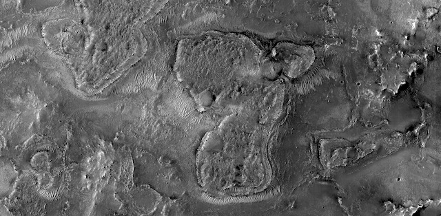
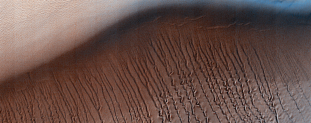
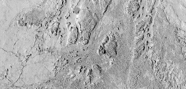
THEMIS Image of the Day, October 26, 2017. This image shows part of the dune field near Meroe Patera. High resolution imaging by other spacecraft has revealed that the dunes in this region are moving. Winds are blowing the dunes across a rough surface of regional volcanic lava flows. The paterae are calderas on the volcanic complex called Syrtis Major Planum. Dunes are found in both Nili and Meroe Paterae and in the region between the two calderas.

High resolution imaging by other spacecraft has revealed that the dunes in this region are moving. Winds are blowing the dunes across a rough surface of regional volcanic lava flows. The paterae are calderas on the volcanic complex called Syrtis Major Planum. Dunes are found in both Nili and Meroe Paterae and in the region between the two calderas.

NASA’s Mars Odyssey spacecraft has spent over 15 years in orbit around Mars, circling the planet more than 69,000 times. It holds the record for longest working spacecraft at Mars. THEMIS, the IR/VIS camera system, has collected data for the entire mission and provides images covering all seasons and lighting conditions.

Over the years many features of interest have received repeated imaging, building up a suite of images covering the entire feature. From the deepest chasma to the tallest volcano, individual dunes inside craters and dune fields that encircle the north pole, channels carved by water and lava, and a variety of other feature, THEMIS has imaged them all.

For the next several months the Image of the Day will focus on the Tharsis volcanoes, the various chasmata of Valles Marineris, and the major dunes fields. We hope you enjoy these images!

More THEMIS Images of the Day by geological topic.

Posted in Reports | Tagged , , , , , , , , , , , , | Comments Off

MARCI weather report, October 16-22, 2017

MARCI-October-17-2017Dust-lifting activity near the north polar ice cap swept diffuse dust clouds southward to the plains of Acidalia this past week. Looking further south, short-lived local-scale dust storms were spotted northwest of Elysium Mons. In the mid-latitudes, water-ice orographic clouds partially obscured the slopes of Elysium, Olympus, and the Tharsis… [More at link, including video]

Posted in Reports | Tagged , , , , , , , , , , , , , | Comments Off

HiRISE: Mars 2020 candidate landing site in NE Syrtis Major

tumblr_oy9d58I4dq1rlz4gso1_1280A candidate landing site for 2020 mission in the northeast Syrtis Major region. Beautiful Mars series.

Posted in Reports | Tagged , , , , , , , , , , , | Comments Off

THEMIS: Large wrinkle ridge in Meroe Patera

Large wrinkle ridge in Meroe Patera (THEMIS_IOTD_20171025)THEMIS Image of the Day, October 25, 2017. This image shows part of the dune field near Meroe Patera. The large ropy ridge running down the picture is a wrinkle ridge. These are caused when compression forces cause lava flows to buckle along a line of weakness. A similar effect occurs in your palm when you cup your hand.

High resolution imaging by other spacecraft has revealed that the dunes in this region are moving. Winds are blowing the dunes across a rough surface of regional volcanic lava flows. The paterae are calderas on the volcanic complex called Syrtis Major Planum. Dunes are found in both Nili and Meroe Paterae and in the region between the two calderas.

NASA’s Mars Odyssey spacecraft has spent over 15 years in orbit around Mars, circling the planet more than 69,000 times. It holds the record for longest working spacecraft at Mars. THEMIS, the IR/VIS camera system, has collected data for the entire mission and provides images covering all seasons and lighting conditions.

Over the years many features of interest have received repeated imaging, building up a suite of images covering the entire feature. From the deepest chasma to the tallest volcano, individual dunes inside craters and dune fields that encircle the north pole, channels carved by water and lava, and a variety of other feature, THEMIS has imaged them all.

For the next several months the Image of the Day will focus on the Tharsis volcanoes, the various chasmata of Valles Marineris, and the major dunes fields. We hope you enjoy these images!

More THEMIS Images of the Day by geological topic.

Posted in Reports | Tagged , , , , , , , , , , , | Comments Off

HiRISE: Squiggles in Hellas Planitia

ESP_051770_1345At around 2,200 kilometers in diameter, Hellas Planitia is the largest visible impact basin in the Solar System, and hosts the lowest elevations on Mars’ surface as well as a variety of landscapes. This image covers a small central portion of the basin and shows a dune field with lots of dust devil trails.

In the middle, we see what appears to be long and straight “scratch marks” running down the southeast (bottom-right) facing dune slopes. If we look closer, we can see these scratch marks actually squiggle back and forth on their way down the dune. These scratch marks are linear gullies. [More at link]

Posted in Reports | Tagged , , , , , , , , , , | Comments Off

Curiosity update: Space is hard

1853ML0096880000703124E01_DXXX-br2Sols 1853-54, October 24, 2017, update by MSL scientist Scott Guzewich: Our exploration of space, and Gale Crater specifically, is enabled by incredible technology and amazing engineers and scientists. But, circumstances constantly remind us that space is hard. It’s a hostile environment to both people and technology and we have to strive constantly to keep things working so we can continue to explore Gale Crater. Since last December, that has involved Curiosity’s team of engineers and scientists working to diagnose and then work-around a problem with the drill. That effort has made excellent progress and we hope to be able to drill Mars rocks again in the not-too-distant future! Associated with that is designing new methods to deliver samples of those rocks to Curiosity’s laboratories: CheMin and SAM. Mastcam imaged the inlets for SAM on the rover deck yestersol.

We prepared a packed science plan for Curiosity today, including a SAM analysis of a “doggy-bagged” sample of martian sand from a location called “Ogunquit Beach” that the rover visited months ago and a… [More at link]

Posted in Reports | Tagged , , , , , , , , , | Comments Off

HiRISE: Platy flow in Elysium Planitia

tumblr_oy9cokAbgH1rlz4gso3_1280A channel segment amid platy-ridged flows in central Elysium Planitia. Beautiful Mars series.

Posted in Reports | Tagged , , , , , , , , , , , | Comments Off

THEMIS: Dunes, wrinkle ridges, wind streaks

Wrinkle ridges, dunes, and wind streaks (THEMIS_IOTD_20171024)THEMIS Image of the Day, October 24, 2017. This image shows part of the dune field near Meroe Patera. High resolution imaging by other spacecraft has revealed that the dunes in this region are moving. Winds are blowing the dunes across a rough surface of regional volcanic lava flows. The paterae are calderas on the volcanic complex called Syrtis Major Planum. Dunes are found in both Nili and Meroe Paterae and in the region between the two calderas.

NASA’s Mars Odyssey spacecraft has spent over 15 years in orbit around Mars, circling the planet more than 69,000 times. It holds the record for longest working spacecraft at Mars. THEMIS, the IR/VIS camera system, has collected data for the entire mission and provides images covering all seasons and lighting conditions.

Over the years many features of interest have received repeated imaging, building up a suite of images covering the entire feature. From the deepest chasma to the tallest volcano, individual dunes inside craters and dune fields that encircle the north pole, channels carved by water and lava, and a variety of other feature, THEMIS has imaged them all.

For the next several months the Image of the Day will focus on the Tharsis volcanoes, the various chasmata of Valles Marineris, and the major dunes fields. We hope you enjoy these images!

More THEMIS Images of the Day by geological topic.

Posted in Reports | Tagged , , , , , , , , , , , , | Comments Off

Opportunity: Composite view toward north

4886-navcam1F561938584EFFD0DMP1212R0M1Sol 4886, October 22, 2017. Above is a composite view of Navcam shots starting with one that looks straight up the slope Opportunity is parked on (left side) and continuing on the north side around to look straight downslope (right side), thus profiling the Perseverence Valley channel.

At right are the front and rear Hazcam views. (Click any image to enlarge it.)

1R561938743EFFD0DMP1312R0M1Opportunity raw images, its latest mission status, location map, and atmospheric opacity, known as tau.

Posted in Reports | Tagged , , , , , , | Comments Off

Curiosity: Progress toward resumed drilling

PIA22063_hiresNASA’s Mars rover Curiosity team is working to restore Curiosity’s sample-drilling capability using new techniques. The latest development is a preparatory test on Mars.

The five-year-old mission is still several months from the soonest possible resumption of drilling into Martian rocks. Managers are enthusiastic about successful Earth-based tests of techniques to work around a mechanical problem that appeared late last year and suspended use of the rover’s drill.

“We’re steadily proceeding with due caution to develop and test ways of using the rover differently from ever before, and Curiosity is continuing productive investigations that don’t require drilling,” said Deputy Project Manager Steve Lee, of NASA’s Jet Propulsion Laboratory, Pasadena, California.

Curiosity touched its drill to the ground Oct. 17 for the first time in 10 months. It pressed the drill bit downward, and then applied smaller sideways forces while taking measurements with a force sensor.

“This is the first time we’ve ever placed the drill bit directly on a Martian rock without stabilizers,” said JPL’s Douglas Klein, chief engineer for the mission’s return-to-drilling development. “The test is to gain better understanding of how the force/torque sensor on the arm provides information about side forces.” [More at link]

Posted in Reports | Tagged , , , , , , , , | Comments Off