HiRISE: Window into the past

ESP_051841_1750The layered sedimentary deposits inside the giant canyons of Mars have puzzled scientists for decades. These light toned deposits have fine, horizontal laminations that are unlike the rugged rim rock of the Valles Marineris.

Various ideas for the origin of the layered sediments have suggested lake deposits, wind blown dust and sand, or volcanic materials that erupted after the canyon was formed, and possibly filled with water.

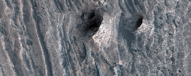
One particular layered deposit, called Ceti Mensa, attracted attention because its deep red color in images collected by the Viking Orbiter mission during the 1970s. Located in west Candor Chasma in the north of the Valles Marineris, Ceti Mensa is an undulating plateau that rises 3 kilometers above the canyon floor and is bounded by steep scarps up to 1.5 kilometers in height. Deep red hues are on the west-facing scarp in particular. The red tint may be due to the presence of crystalline ferric oxide, suggesting that the material may have been exposed to heat or water, or both. [More at link]

Posted in Reports | Tagged , , , , , , , , , , , | Comments Off

Curiosity update: Feeding SAM some sand

NLB_561731647EDR_F0661804NCAM00353M_-br2Sol 1852, October 20, 2017, update by MSL scientist Ken Herkenhoff: MSL drove over 20 meters on Sol 1850, to an area with lots of bedrock exposed. We had several nice targets to choose from, but were limited in what we could plan because we want to prepare for a SAM evolved gas analysis (EGA) of sand from “Ogunquit Beach,” which requires significant power. We are planning only 2 sols today, to get synced back up with “Mars time” on Monday, so will not be driving this weekend.

Despite the power constraints, we were able to plan a lot of activities today. Sol 1852 will start with Navcam searches for clouds and dust devils, followed by Mastcam mosaics of the expected path ahead (southward). Then ChemCam and Right Mastcam will observe bedrock target “Balfour” and a block named “Ripon.” Late that afternoon, MAHLI will acquire a full suite of images of Balfour before APXS is placed on it for an overnight integration. We considered brushing Balfour… [More at link]

Posted in Reports | Tagged , , , , , , , , , , , , , | Comments Off

THEMIS: Thin lines of dunes on Meroe Patera

Dunes in Meroe Patera (THEMIS_IOTD_20171023)THEMIS Image of the Day, October 23, 2017. This image shows part of the dune field near Meroe Patera. High resolution imaging by other spacecraft has revealed that the dunes in this region are moving. Winds are blowing the dunes across a rough surface of regional volcanic lava flows. The paterae are calderas on the volcanic complex called Syrtis Major Planum. Dunes are found in both Nili and Meroe Paterae and in the region between the two calderas.

NASA’s Mars Odyssey spacecraft has spent over 15 years in orbit around Mars, circling the planet more than 69,000 times. It holds the record for longest working spacecraft at Mars. THEMIS, the IR/VIS camera system, has collected data for the entire mission and provides images covering all seasons and lighting conditions.

Over the years many features of interest have received repeated imaging, building up a suite of images covering the entire feature. From the deepest chasma to the tallest volcano, individual dunes inside craters and dune fields that encircle the north pole, channels carved by water and lava, and a variety of other feature, THEMIS has imaged them all.

For the next several months the Image of the Day will focus on the Tharsis volcanoes, the various chasmata of Valles Marineris, and the major dunes fields. We hope you enjoy these images!

More THEMIS Images of the Day by geological topic.

Posted in Reports | Tagged , , , , , , , , , , | Comments Off

HiRISE: A highly disrupted crater

tumblr_oxq14dq3pP1rlz4gso1_1280This 2.5-kilometer diameter crater has been significantly altered from the usual bowl-shaped appearance we associate with craters. Material has covered significant portions of the ejecta and filled in the crater. This fill material has since been subject to erosion—like boulders weathering out of the slopes—and the crater rim is also highly irregular.

This crater is located in Elysium Planitia, an area dominated by volcanic processes. It’s likely that the crater fill material is volcanic in origin, and possible that the rim was etched by lava, either flowing into the crater or spilling over after the crater filled completely. However, there are also signs of erosion by wind, like the parallel ridges in the rim breaches and between high-standing regions of the crater fill. It’s likely that the current appearance of this crater is due to a combination of surface processes. [More at link]

Posted in Reports | Tagged , , , , , , , , , | Comments Off

Opportunity spends the week imaging

4884-la-bajada-pancamFCOpportunity Status Report, October 20, 2017: Opportunity is continuing her winter exploration of “Perseverance Valley” on the west rim of Endeavour Crater.

Although winter conditions are constraining activity, rover energy production has improved slightly, and more of the earlier relay passes from the Mars Reconnaissance Orbiter are helping, as well. Opportunity has been able to avoid having to dedicate any sols to battery recharging.

The rover spent seven consecutive sols, Sols 4876 to 4882 (Oct. 11 to Oct. 17, 2017), collecting Panoramic Camera (Pancam) panoramas of the subject, called “La Bajada,” totaling over 40 color stereo image pairs. Also, on Sol 4876 (Oct. 11, 2017), Opportunity was able to support an evening atmospheric argon measurement with the Alpha Particle X-ray Spectrometer (APXS).

[Editor’s note: The composite image above is from Sol 4884 (October 20) and uses false-color Pancam images by Holger Isenberg. It shows part of the La Bajada target area; click the image to enlarge it.]

Posted in Reports | Tagged , , , , , , , | Comments Off

ExoMars aerobraking becomes too severe; shifts automatically to higher orbit

ExoMars-FCT-1024x709ExoMars has successfully performed a Flux Reduction Manoeuvre (FRM) for the first time. The manoeuvre was triggered by the excessive density of Mars’ atmosphere, which had slowed the spacecraft above the limit the operations team normally allows.

The manoeuvre happened on 19 September, just a month before ExoMars’ first arrival anniversary.

FRM together with the so-called ‘Popup’ manoeuvre are the spacecraft’s automatic responses meant to save it from critical conditions that could cause damage, such as excessive heat or deceleration.

They both trigger the propulsion system to bring the spacecraft out of a current (problematic) orbit into a higher orbit. The FRM raises the orbit by just a little so that aerobraking can continue with reduced drag. (…)

Unfortunately, predicting the Martian atmosphere is very complex and conditions can change significantly from one orbit to the next, hence these automatic manoeuvres are maintained on-board by the team in case the spacecraft encounters a much denser atmosphere than expected. [More at link]

Posted in Reports | Tagged , , , , , , , , | Comments Off

THEMIS: Wind streaks near Meroe Patera

Northeast winds make streaks in Syrtis Major (THEMIS_IOTD_20171020)THEMIS Image of the Day, October 20, 2017. This image shows part of the dune field near Meroe Patera. High resolution imaging by other spacecraft has revealed that the dunes in this region are moving. Winds from the northeast (upper right) are blowing the dunes across a rough surface of regional volcanic lava flows and leaving wind streaks behind craters. The paterae are calderas on the volcanic complex called Syrtis Major Planum. Dunes are found in both Nili and Meroe Paterae and in the region between the two calderas.

NASA’s Mars Odyssey spacecraft has spent over 15 years in orbit around Mars, circling the planet more than 69,000 times. It holds the record for longest working spacecraft at Mars. THEMIS, the IR/VIS camera system, has collected data for the entire mission and provides images covering all seasons and lighting conditions.

Over the years many features of interest have received repeated imaging, building up a suite of images covering the entire feature. From the deepest chasma to the tallest volcano, individual dunes inside craters and dune fields that encircle the north pole, channels carved by water and lava, and a variety of other feature, THEMIS has imaged them all.

For the next several months the Image of the Day will focus on the Tharsis volcanoes, the various chasmata of Valles Marineris, and the major dunes fields. We hope you enjoy these images!

More THEMIS Images of the Day by geological topic.

Posted in Reports | Tagged , , , , , , , , , , , | Comments Off

Solar eruptions could electrify Martian moons

Powerful solar eruptions could electrically charge areas of the Martian moon Phobos to hundreds of volts, presenting a complex electrical environment that could possibly affect sensitive electronics carried by future robotic explorers, according to a new NASA study. The study also considered electrical charges that could develop as astronauts transit the surface on potential human missions to Phobos.

Phobos has been considered as a possible initial base for human exploration of Mars because its weak gravity makes it easier to land spacecraft, astronauts and supplies. The idea would be to have the astronauts control robots on the Martian surface from the moons of Mars, without the considerable time delay faced by Earth-based operators.

“We found that astronauts or rovers could accumulate significant electric charges when traversing the night side of Phobos — the side facing Mars during the Martian day,” said William Farrell of NASA’s Goddard Space Flight Center, Greenbelt, Maryland. “While we don’t expect these charges to be large enough to injure an astronaut, they are potentially large enough to affect sensitive equipment, so we would need to design spacesuits and equipment that minimizes any charging hazard.”

Farrell is lead author of a paper on this research published online Oct. 3 in Advances in Space Research. [More at links]

Posted in Reports | Tagged , , , , | Comments Off

Curiosity update: A change of scenery

NLB_561562205EDR_F0661654NCAM00312M_-br2Sol 1850-51, October 18, 2017, update by MSL scientist Mark Salvatore: Since the start of our investigation of the Vera Rubin Ridge (VRR, a narrow and winding ridge that exhibits signs of oxidized iron phases from orbit), we’ve been primarily driving around on fractured bedrock material with a general lack of sand. This is unlike the landscape in the Murray formation at the base of the ridge, which was dominated by a combination of bedrock exposures and wind-mobilized sands. However, following Curiosity’s drive two days ago, the team found a local landscape dominated by small cobbles and pebbles with an abundance of fine soil surrounding these fragments. We had planned to investigate this location based on both ground- and satellite-based observations due to its different appearance relative to the rest of VRR, but this was our first up-close glimpse of this different landscape.

The science team had a few decisions to make during today’s planning session. There was time available to use the MAHLI (high-resolution imaging) and APXS (bulk chemistry) instruments located on Curiosity’s arm to investigate the surroundings, and the team was able to choose to perform either a quick “touch and go” analysis (where we are able to drive away the same day as making the measurements) or a… [More at link]

Posted in Reports | Tagged , , , , , , , , , , , | Comments Off

MAVEN: Mars has a twisted magnetotail

mars-twisted-tailMars has an invisible magnetic “tail” that is twisted by interaction with the solar wind, according to new research using data from MAVEN.

MAVEN is in orbit around Mars gathering data on how the Red Planet lost much of its atmosphere and water, transforming from a world that could have supported life billions of years ago into a cold and inhospitable place today. The process that creates the twisted tail could also allow some of Mars’ already thin atmosphere to escape to space, according to the research team.

“We found that Mars’ magnetic tail, or magnetotail, is unique in the solar system,” said Gina DiBraccio of NASA’s Goddard Space Flight Center in Greenbelt, Maryland. “It’s not like the magnetotail found at Venus, a planet with no magnetic field of its own, nor is it like Earth’s, which is surrounded by its own internally generated magnetic field. Instead, it is a hybrid between the two.”

DiBraccio is project scientist for MAVEN and presented this research at a press briefing Thursday, Oct. 19, during the 49th annual meeting of the American Astronomical Society’s Division for Planetary Sciences in Provo, Utah. [More at links]

[Editor’s note: A Powerpoint presentation (45 MB) is available here.]

Posted in Reports | Tagged , , , , , , | Comments Off