


-
Recent Posts
Archives
Links
general
mission instruments
- CRISM: Compact Reconnaissance Imaging Spectrometer for Mars
- CTX: Context Camera
- HiRISE: High Resolution Imaging Science Experiment
- MARSIS: Mars Advanced Radar for Subsurface and Ionosphere Sounding
- SHARAD: Shallow Radar
- THEMIS: Thermal Emission Imaging System
missions
- All Mars missions list
- Curiosity rover
- ExoMars
- Hope (al-Amal) orbiter
- InSight
- Mars Atmosphere and Volatile Evolution Mission (MAVEN)
- Mars Exploration Rovers (MER)
- Mars Express (MEX)
- Mars Odyssey
- Mars Orbiter Mission (MOM) / Mangalyaan
- Mars Reconnaissance Orbiter (MRO)
- Mars Science Laboratory (MSL)
- Perseverance Rover
- Tianwen-1 orbiter/rover
news
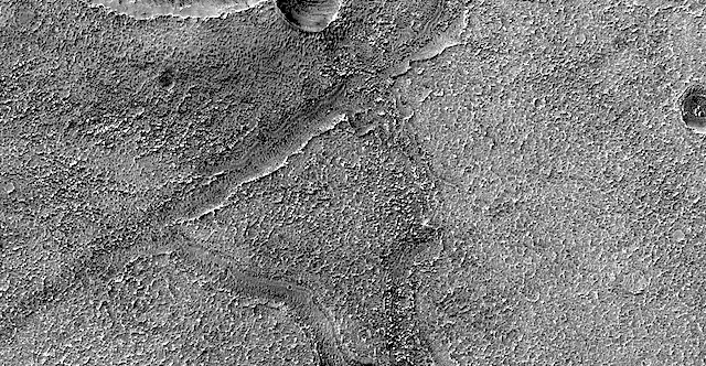
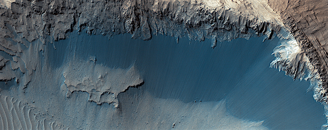
HiRISE: Fresh shallow valleys
Posted in Reports
Tagged Beautiful Mars, High Resolution Imaging Science Experiment, HiRISE, Mars Reconnaissance Orbiter, MRO, NASA, Terra Cimmeria, University of Arizona, valleys
Comments Off
Missions could make oxygen on Mars using plasma technology
 Plasma technology could hold the key to creating a sustainable oxygen supply on Mars, a new study has found.
It suggests that Mars, with its 96 per cent carbon dioxide atmosphere, has nearly ideal conditions for creating oxygen from CO2 through a process known as decomposition.
Published today in the journal Plasma Sources Science and Technology, the research by the universities of Lisbon and Porto, and École Polytechnique in Paris, shows that the pressure and temperature ranges in the Martian atmosphere mean non-thermal (or non-equilibrium) plasma can be used to produce oxygen efficiently.
Lead author Dr Vasco Guerra, from the University of Lisbon, said: “Sending a manned mission to Mars is one of the next major steps in our exploration of space. Creating a breathable environment, however, is a substantial challenge.
“Plasma reforming of CO2 on Earth is a growing field of research, prompted by the problems of climate change and production of solar fuels. Low temperature plasmas are one of the best media for CO2 decomposition – the split-up of the molecule into oxygen and carbon monoxide – both by direct electron impact, and by transferring electron energy into vibrational excitation.” [More at links]
Take a walk on Mars — from home
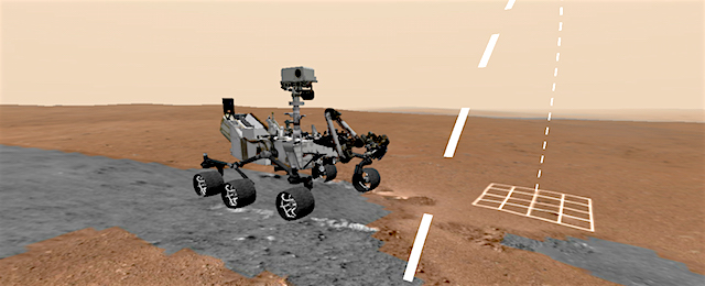 When NASA scientists want to follow the path of the Curiosity rover on Mars, they can don a mixed-reality headset and virtually explore the Martian landscape.
Starting today, everyone can get a taste of what that feels like. NASA’s Jet Propulsion Laboratory in Pasadena, California, collaborated with Google to produce Access Mars, a free immersive experience. It’s available for use on all desktop and mobile devices and virtual reality/augmented reality (VR/AR) headsets. That includes mobile-based virtual reality devices on Apple and Android.
The experience was adapted from JPL’s OnSight software, which assists scientists in planning rover drives and even holding meetings on Mars. Imagery from NASA’s Curiosity rover provided the terrain, allowing users to wander the actual dunes and valleys explored by the spacecraft. Since being rolled out to JPL’s scientists in 2015, OnSight has made studying Martian geology as intuitive as turning your head and walking around.
Access Mars lets anyone with an internet connection take a guided tour of what those scientists experience. A simple walkthrough explains what the Curiosity rover does and details its dramatic landing in 2012. Users also can visit four sites that have been critical to NASA’s Mars Science Laboratory mission: Curiosity’s landing site; Murray Buttes; Marias Pass and Pahrump Hills. Additionally, the rover’s latest location on lower Mt. Sharp will be periodically updated to reflect the mission’s ongoing progress. [More at link]
Posted in Reports
Tagged Aeolis Mons, Curiosity, Gale Crater, Marias Pass, Mars Science Laboratory, Mount Sharp, MSL, Murray Formation, NASA, OnSight, Pahrump Hills, Vera Rubin Ridge, virtual reality
Comments Off
THEMIS: Dunes in Nili Patera
 THEMIS Image of the Day, October 19, 2017. This is a false color image of part of the Nili Patera dune field. High resolution imaging by other spacecraft has revealed that the dunes in this region are moving. Winds are blowing the dunes across a rough surface of regional volcanic lava flows. The paterae are calderas on the volcanic complex called Syrtis Major Planum. Dunes are found in both Nili and Meroe Paterae and in the region between the two calderas.
The THEMIS VIS camera contains 5 filters. The data from different filters can be combined in multiple ways to create a false color image. These false color images may reveal subtle variations of the surface not easily identified in a single band image.
NASA’s Mars Odyssey spacecraft has spent over 15 years in orbit around Mars, circling the planet more than 69,000 times. It holds the record for longest working spacecraft at Mars. THEMIS, the IR/VIS camera system, has collected data for the entire mission and provides images covering all seasons and lighting conditions.
Over the years many features of interest have received repeated imaging, building up a suite of images covering the entire feature. From the deepest chasma to the tallest volcano, individual dunes inside craters and dune fields that encircle the north pole, channels carved by water and lava, and a variety of other feature, THEMIS has imaged them all.
For the next several months the Image of the Day will focus on the Tharsis volcanoes, the various chasmata of Valles Marineris, and the major dunes fields. We hope you enjoy these images!
More THEMIS Images of the Day by geological topic.
Posted in Reports
Tagged Arizona State University, ASU, Mars Odyssey, NASA, Nili Patera, sand dunes, THEMIS, THEMIS Image of the Day, Thermal Emission Imaging System, volcanics
Comments Off
MARCI weather report, October 9-15, 2017
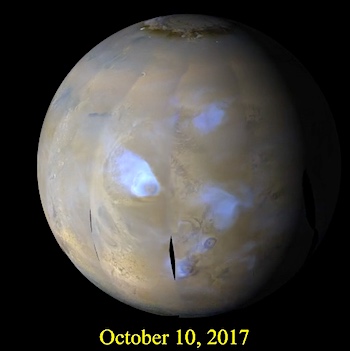 The dominant weather feature last week was the aphelion equatorial condensate (water-ice) cloud belt. Predominately a northern hemisphere feature, it does extend a distance into the southern tropics. In addition, orographic condensate clouds were observed over all the major shield volcanoes across the planet. In terms of dust storm activity, occasional local dust storms were observed extending southward from the… [More at link, including video]
Posted in Reports
Tagged atmosphere, clouds, dust, haze, Malin Space Science Systems, MARCI, Mars Color Imager, Mars Reconnaissance Orbiter, MRO, MSSS, NASA, storms, weather, wind
Comments Off
Seeking microbial biosignatures for studying Mars rocks
 Scientists around Tetyana Milojevic from the Faculty of Chemistry at the University of Vienna are in search of unique biosignatures, which are left on synthetic extraterrestrial minerals by microbial activity. The biochemist and astrobiologist investigates these signatures at her own miniaturized “Mars farm” where she can observe interactions between the archaeon Metallosphaera sedula and Mars-like rocks. These microbes are capable of oxidizing and integrating metals into their metabolism. The original research was currently published in the journal Frontiers in Microbiology.
At the Department of Biophysical Chemistry at the University of Vienna, Tetyana Milojevic and her team have been operating a miniaturized “Mars farm” in order to simulate ancient and probably extinct microbial life – based on gases and synthetically produced Martian regolith of diverse composition. The team investigates interactions between Metallosphaera sedula, a microbe that inhabits extreme environments, and different minerals which contain nutrients in form of metals. Metallosphaera sedula is a chemolithotroph, means being capable of metabolizing inorganic substances like iron, sulphur and uranium as well.
To satisfy microbial nutritional fitness, the research team uses mineral mixtures that mimic the Martian regolith composition from different locations and historical periods of Mars: “JSC 1A” is mainly composed of palagonite – a rock that was created by lava; “P-MRS” is rich in hydrated phyllosilicates; the sulfate containing “S-MRS”, emerging from acidic times on Mars and the highly porous “MRS07/52″ that consists of silicate and iron compounds and simulates sediments of the Martian surface.
“We were able to show that due to its metal oxidizing metabolic activity, when given an access to these Martian regolith simulants, M. sedula actively colonizes them, releases soluble metal ions into the leachate solution and alters their mineral surface leaving behind specific signatures of life, a ‘fingerprint’, so to say”, explains Milojevic. The observed metabolic activity of M. sedula coupled to the release of free soluble metals can certainly pave the way to extraterrestrial biomining, a technique which extracts metals from ores, launching the biologically assisted exploitation of raw materials from asteroids, meteors and other celestial bodies… [More at links]
Posted in Reports
Tagged biosignatures, hydrated minerals, hydrated sulfates, life, Metallosphaera sedula, microorganisms, palagonite, phyllosilicates, regolith
Comments Off
Opportunity report, Sol 4864, by A.J.S. Rayl, The Planetary Society
 October 2, 2017: Opportunity Braves Onset of Winter to Picture Perseverance. The Martian winter began to grip Endeavour Crater in September, slowing the pace of the Mars Exploration Rovers mission. But Opportunity braved the brutal cold in Perseverance Valley and followed her commands to visually document everything in sight with images, and even check out a couple of pebbles up close.
The veteran robot field geologist is on a small rise along the southern ‘wall’ or side of the valley, which cuts into the western rim of Endeavour at Cape Byron. Opportunity drove onto the slope, at the end of August. The second of seven planned science stops on a route that extends from the top to the bottom of the valley and the interior of Endeavour Crater, the site is about a third of the way down the valley. Known simply as station 2, it’s where the rover would spend the month of September.
“Winter is setting in and we’re getting cold,” said MER Chief of Engineering Bill Nelson, of the Jet Propulsion Laboratory (JPL), the NASA center that has produced all of the American Mars rovers. (…)
Opportunity is producing enough energy to survive and to work, but she’s had to use a lot of that energy just to keep warm. The robot’s two rechargeable lithium ion [Li-ion] batteries, which provide energy for the rover when the Sun isn’t shining, are in effect her heartbeat. That heartbeat is being strained and the depths of the season are still ahead. (…)
“The morphology of the valley is quite interesting … there’s a little more diversity of rocks here than what I think we expected,” Golombek elaborated. “You never know what you’re going to get until you get there, but it looks like there are different things here. If there are other rock types, then maybe they can tell us something about the structure, the rim of the crater, and the erosion that’s occurred to preserve it.” [More at link]
Posted in Reports
Tagged Cape Byron, Endeavour Crater, Mars Exploration Rover, MER, NASA, Opportunity, Perseverance Valley
Comments Off
HiRISE: Where does the sand come from?
 The grains of sand that make up sand dunes on Earth and Mars have a hazardous existence because of the way that they travel. Wind-blown sand is lifted above the surface of each planet before crashing onto the ground and bouncing in a sequence of repeated hops, a process called saltation.
Sand grains can also roll along the ground as they are blown by the wind, and they are also jostled by other sand gains that are similarly flying across the surface. All of these repeated impacts tend to wear down the sand grains, smoothing them into a more spherical shape and breaking off small fragments that supply the vast dust deposits of Mars. This process (known as comminution) ultimately destroys sand grains and limits the length of time that the particles exist. The fact that we see active sand dunes on Mars today… [More at link]
Posted in Reports
Tagged High Resolution Imaging Science Experiment, HiRISE, Mars Reconnaissance Orbiter, MRO, NASA, sand, sand dunes, sand grains, University of Arizona
Comments Off
THEMIS: Nili Patera dunes in false color
 THEMIS Image of the Day, October 18, 2017. This is a false color image of part of the Nili Patera dune field. High resolution imaging by other spacecraft has revealed that the dunes in this region are moving. Winds are blowing the dunes across a rough surface of regional volcanic lava flows. The paterae are calderas on the volcanic complex called Syrtis Major Planum. Dunes are found in both Nili and Meroe Paterae and in the region between the two calderas.
The THEMIS VIS camera contains 5 filters. The data from different filters can be combined in multiple ways to create a false color image. These false color images may reveal subtle variations of the surface not easily identified in a single band image.
NASA’s Mars Odyssey spacecraft has spent over 15 years in orbit around Mars, circling the planet more than 69,000 times. It holds the record for longest working spacecraft at Mars. THEMIS, the IR/VIS camera system, has collected data for the entire mission and provides images covering all seasons and lighting conditions.
Over the years many features of interest have received repeated imaging, building up a suite of images covering the entire feature. From the deepest chasma to the tallest volcano, individual dunes inside craters and dune fields that encircle the north pole, channels carved by water and lava, and a variety of other feature, THEMIS has imaged them all.
For the next several months the Image of the Day will focus on the Tharsis volcanoes, the various chasmata of Valles Marineris, and the major dunes fields. We hope you enjoy these images!
More THEMIS Images of the Day by geological topic.
Posted in Reports
Tagged Arizona State University, ASU, false color, Mars Odyssey, NASA, Nili Patera, sand dunes, Syrtis Major, THEMIS, THEMIS Image of the Day, Thermal Emission Imaging System, volcanics
Comments Off
How water could flow on icy early Mars
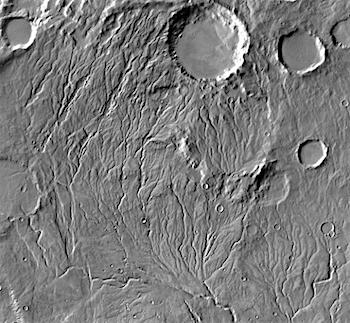 Research by planetary scientists at Brown University finds that periodic melting of ice sheets on a cold early Mars would have created enough water to carve the ancient valleys and lakebeds seen on the planet today.
For scientists trying to understand what ancient Mars might have been like, the red planet sends some mixed signals. Water-carved valleys and lakebeds leave little doubt that water once flowed on the surface. But climate models for early Mars suggest average temperatures around the globe stayed well below freezing.
A recent study led by Brown University geologists offers a potential bridge between the “warm and wet” story told by Martian geology and the “cold and icy” past suggested by atmospheric models. The study shows that it’s plausible, even if Mars was generally frozen over, that peak daily temperatures in summer might sneak above freezing just enough to cause melting at the edges of glaciers. That meltwater, produced in relatively small amounts year after year, could have been enough to carve the features observed on the planet today, the researchers conclude.
The study is published online in the journal Icarus. Ashley Palumbo, a Ph.D. student at Brown, led the work with Jim Head, a professor in Brown’s Department of Earth, Environmental and Planetary Science, and Robin Wordsworth, a professor in Harvard’s School of Engineering and Applied Sciences. [More at links]