Curiosity update: How far we’ve come

NRB_561372639EDR_F0661516NCAM00281M_-br2
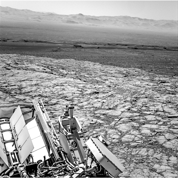
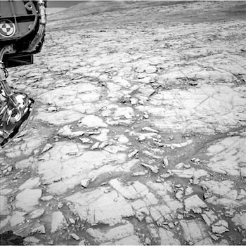
Sol 1848-49, October 17, 2017, update by MSL scientist Lauren Edgar: Today felt like any other planning day: a straightforward plan involving remote sensing, a drive, post-drive imaging, and some untargeted observations on the second sol. Just a typical day in the office. Maybe even an easy one. It wasn’t until I sat down to write this blog that I fully processed how far we’ve come and just how awesome Curiosity’s “office” is. I was looking through the drive imagery and came across this Navcam frame (posted above), which looks down on the Murray Buttes and Bagnold Dune Field, across Aeolis Palus and the northern rim of Gale crater. It’s pretty spectacular to see just how much we’ve explored in 5 years. But that was just a quick glance over Curiosity’s shoulder (or the RTG, which hangs off the back of the rover), because our sights were mostly set on the terrain ahead of us to choose where to go next… [More at link]

Posted in Reports | Tagged , , , , , , , , , , , , , | Comments Off

Mars Express webcam surveys high-altitude clouds

Cloud_over_MarsAn unprecedented catalogue of more than 21,000 images taken by a webcam on ESA’s Mars Express is proving its worth as a science instrument, providing a global survey of unusual high-altitude cloud features on the Red Planet.

The low-resolution camera was originally installed on Mars Express for visual confirmation that the Beagle-2 lander had separated in 2003. In 2007 it was switched back on and used primarily for outreach, education and citizen science, with images automatically posted to a dedicated Flickr page, sometimes within just 75 minutes of being taken at Mars.

Last year, with new software, the camera was adopted as a supporting science instrument. Now, the first paper has been published [in Icarus], on detached, high-altitude cloud features and dust storms over the edge, or ‘limb’, of the planet.

While these limb clouds can be imaged by other instruments or spacecraft, it is not necessarily their main task – they are usually looking directly at the surface with a narrow field of view that covers a small portion of the planet for specialised study. By contrast, the webcam often has a global view of the full limb.

“For this reason, limb observations in general are not so numerous, and this is why our images are so valuable in contributing to our understanding of atmospheric phenomena, ” says Agustin Sánchez-Lavega, lead author of the study from the University del Pais Vasco in Bilbao, Spain.

“Combining with models and other datasets we were able to gain a better insight to understanding atmospheric transport and seasonal variations that play a role in generating the high-altitude cloud features.” [More at links]

Posted in Reports | Tagged , , , , , , , | Comments Off

Opportunity: Recent drive improves energy levels slightly

Opportunity Status Report, October 16, 2017: Opportunity is continuing her winter exploration of “Perseverance Valley” on the west rim of Endeavour Crater.

The cold, low-light winter conditions continue to constrain activity, although with a recent drive, energy levels have improved slightly. Sol 4873 (Oct. 8, 2017), was a recharge sol and sol 4872 (Oct. 7, 2017), had little activity.

Opportunity drove on Sol 4874 (Oct. 9, 2017), about 59 feet (18 meters) back up slope to visit some interesting geology. The end-of-drive location provided favorable solar orientation, improving power production. When not driving or recharging, the rover is collecting extensive Panoramic Camera (Pancam) stereo panoramas of the surrounding geology… [More at link]

Posted in Reports | Tagged , , , , , , | Comments Off

HiRISE: Pitted material in large crater

tumblr_oxw43uJaiG1rlz4gso1_1280Pitted material in large crater north of Hellas Planitia. Beautiful Mars series.

Posted in Reports | Tagged , , , , , , , | Comments Off

THEMIS: Dunes in Syrtis Major

Dunes in Syrtis Major (THEMIS_IOTD_20171017)THEMIS Image of the Day, October 17, 2017. This image shows part of the Nili Patera dune field. High resolution imaging by other spacecraft has revealed that the dunes in this region are moving. Winds are blowing the dunes across a rough surface of regional volcanic lava flows. The paterae are calderas on the volcanic complex called Syrtis Major Planum. Dunes are found in both Nili and Meroe Paterae and in the region between the two calderas.

NASA’s Mars Odyssey spacecraft has spent over 15 years in orbit around Mars, circling the planet more than 69,000 times. It holds the record for longest working spacecraft at Mars. THEMIS, the IR/VIS camera system, has collected data for the entire mission and provides images covering all seasons and lighting conditions.

Over the years many features of interest have received repeated imaging, building up a suite of images covering the entire feature. From the deepest chasma to the tallest volcano, individual dunes inside craters and dune fields that encircle the north pole, channels carved by water and lava, and a variety of other feature, THEMIS has imaged them all.

For the next several months the Image of the Day will focus on the Tharsis volcanoes, the various chasmata of Valles Marineris, and the major dunes fields. We hope you enjoy these images!

More THEMIS Images of the Day by geological topic.

Posted in Reports | Tagged , , , , , , , , , , | Comments Off

Trace Gas Orbiter: Clouds over lava flows

ImageJ=1.51nDiffuse, water-ice clouds, a hazy sky and a light breeze. Such might have read a weather forecast for the Tharsis volcanic region on Mars on 22 November 2016, when this image was taken by the ExoMars Trace Gas Orbiter.

Clouds, most likely of water-ice, and atmospheric haze in the sky are coloured blue/white in this image.

Below, 630 km west of the volcano Arsia Mons, the southernmost of the Tharsis volcanoes, outlines of ancient lava flows dominate the surface. The dark streaks are due to the action of wind on the dark-coloured basaltic sands, while redder patches are wind blown dust. A handful of small impact craters can also be seen.

The Trace Gas Orbiter, a joint effort between ESA and Roscosmos, arrived at Mars on 19 October last year. Since March it has been repeatedly surfing in and out of the atmosphere, generating a tiny amount of drag that will steadily pull it into a near-circular 400 km altitude orbit. It is expected to begin its full science operational phase from this orbit in early 2018. [More at link]

Posted in Reports | Tagged , , , , , , , , , , | Comments Off

Curiosity update: Winter is coming

NLB_560929716EDR_F0661332NCAM00279M_-br2Sol 1843-44, October 16, 2017, update by MSL scientist Scott Guzewich: The seasons on Mars are long, and even though Curiosity is near the equator, the change in weather between the seasons is noticeable and winter is coming to Gale Crater. Right now it’s late fall in the southern hemisphere on Mars and the colder weather changes how we operate Curiosity. In colder weather, we need more power to heat the instruments and keep Curosity’s electronics and mechanisms warm. This reduces the amount of electricity we have to conduct science, but we were still able to prepare a full plan for the next two sols.

We identified two new bedrock targets to analyze with ChemCam (“Woodlands” and “Montecristo”, which are near the bottom portion of this image [above]). For Sol 1843, we also planned a series of Mastcam images of nearby bedrock targets that were analyzed with ChemCam as well as interesting spots in the distance, including a layered ledge on the Vera Rubin Ridge and a possibly hematite-rich patch called “Iron Mask” which we may drive near in the future. We also will drive approximately 22 m towards our next target on Sol 1843. [More at link]

Posted in Reports | Tagged , , , , , , , , , , , | Comments Off

HRSC: Colorful dunes on wind-swept Mars

Dune_field_in_a_crater_perspective_viewDunes are prominent indicators of prevailing winds, as can be seen on this crater floor on Mars, imaged by ESA’s Mars Express on 16 May.

Depressions such as impact craters can act as traps for sediments that have been blown in from elsewhere, accumulating in various patterns whipped up by strong winds.

The dune field in this unnamed 48 km-wide impact crater in the southern highlands of Mars includes sickle-shaped dunes known as barchans, and parallel ridges of dunes called transverse dunes.

A smoothly distributed sand sheet stretches between the dunes and the western wall of the crater.

Barchans are the most common dune type found on Mars, and are also prevalent in Earth’s deserts. The shallower slope faces the wind, with the steeper, curved slope downwind, the ‘horns’ of the individual dunes pointing in the direction the wind is blowing. In this example, a southeasterly wind at the time of dune formation can be assumed.

Many nearby craters in this region also host dunes, and show a northwest shift of their dune fields relative to the crater centre, arguing for a uniform wind direction from the southeast. [More at link]

Posted in Reports | Tagged , , , , , , , , , , , , | Comments Off

Ancient sea-floor hydrothermal deposits in Eridania

PIA22058_hiresThe discovery of evidence for ancient sea-floor hydrothermal deposits on Mars identifies an area on the planet that may offer clues about the origin of life on Earth.

A recent international report [published in Nature Communications by a team led by Joseph Michalski] examines observations by NASA’s Mars Reconnaissance Orbiter (MRO) of massive deposits in a basin on southern Mars. The authors interpret the data as evidence that these deposits were formed by heated water from a volcanically active part of the planet’s crust entering the bottom of a large sea long ago.

“Even if we never find evidence that there’s been life on Mars, this site can tell us about the type of environment where life may have begun on Earth,” said Paul Niles of NASA’s Johnson Space Center, Houston. “Volcanic activity combined with standing water provided conditions that were likely similar to conditions that existed on Earth at about the same time — when early life was evolving here.”

Mars today has neither standing water nor volcanic activity. Researchers estimate an age of about 3.7 billion years for the Martian deposits attributed to seafloor hydrothermal activity. Undersea hydrothermal conditions on Earth at about that same time are a strong candidate for where and when life on Earth began. Earth still has such conditions, where many forms of life thrive on chemical energy extracted from rocks, without sunlight. But due to Earth’s active crust, our planet holds little direct geological evidence preserved from the time when life began. (…)

Observations by MRO’s Compact Reconnaissance Spectrometer for Mars (CRISM) provided the data for identifying minerals in massive deposits within Mars’ Eridania basin, which lies in a region with some of the Red Planet’s most ancient exposed crust.

“This site gives us a compelling story for a deep, long-lived sea and a deep-sea hydrothermal environment,” Niles said. “It is evocative of the deep-sea hydrothermal environments on Earth, similar to environments where life might be found on other worlds — life that doesn’t need a nice atmosphere or temperate surface, but just rocks, heat and water.” [More at links]

Posted in Reports | Tagged , , , , , , | Comments Off

THEMIS: Meroe and Nili Paterae in Syrtis Major

Nili and Meroe Paterae (THEMIS_IOTD_20171016)THEMIS Image of the Day, October 16, 2017. This image shows part of the Nili Patera dune field. High resolution imaging by other spacecraft has revealed that the dunes in this region are moving. Winds are blowing the dunes across a rough surface of regional volcanic lava flows. The paterae are calderas on the volcanic complex called Syrtis Major Planum. Dunes are found in both Nili and Meroe Paterae and in the region between the two calderas.

NASA’s Mars Odyssey spacecraft has spent over 15 years in orbit around Mars, circling the planet more than 69,000 times. It holds the record for longest working spacecraft at Mars. THEMIS, the IR/VIS camera system, has collected data for the entire mission and provides images covering all seasons and lighting conditions.

Over the years many features of interest have received repeated imaging, building up a suite of images covering the entire feature. From the deepest chasma to the tallest volcano, individual dunes inside craters and dune fields that encircle the north pole, channels carved by water and lava, and a variety of other feature, THEMIS has imaged them all.

For the next several months the Image of the Day will focus on the Tharsis volcanoes, the various chasmata of Valles Marineris, and the major dunes fields. We hope you enjoy these images!

More THEMIS Images of the Day by geological topic.

Posted in Reports | Tagged , , , , , , , , , , | Comments Off