Opportunity: Seven-frame MI closeup on Waverly

4656-7_MI1P541437354ESFCW17P2509L5M1_L2L5L5L7L7Sol 4656, February 28, 2017. The Microscopic Imager usually captures a target with four frames in a 2-by-2 array. This time, at a target named Waverly, there’s a fifth frame added. (Edit: On Sol 4657, the MI added two more frames, left and bottom, to the composite seen above.)

Note the variety of shapes (both round and angular) and light and dark tones among what look like embedded fragments.

At right is a false-color Pancam shot of the rover’s workplane, taken on the sol before, indicating the target area. (Color version by Holger Isenberg.)

Click either image to enlarge it.

Opportunity raw images, its latest mission status, a location map, and atmospheric opacity, known as tau.

Posted in Reports | Tagged , , , , , , , | Comments Off

HiRISE: North polar layers

ESP_018636_2745The North Polar layered deposits are a 3-kilometer thick stack of dusty water ice layers that are about 1000 kilometers across. The layers record information about climate stretching back a few million years into Martian history.

In many locations erosion has created scarps and troughs that expose this layering. The tan colored layers are the dusty water ice of the polar layered deposits; however a section of bluish layers are is visible below them. These bluish layers contain sand-sized rock fragments that likely formed a large polar dunefield before the overlying dusty ice was deposited. [More at link]

Posted in Reports | Tagged , , , , , , | Comments Off

THEMIS: Hills of Ariadnes Colles

Hills in Ariadnes Colles (THEMIS_IOTD_20170228)THEMIS Image of the Day, February 28, 2017. This VIS image shows part of Ariadnes Colles. The term colles means hills. The hills in this image are much brighter than the surroundings, possibly due to erosion or removal of the darker material from the upper elevations of the hills.

More THEMIS Images of the Day by geological topic.


Posted in Reports | Tagged , , , , , , , , | Comments Off

Curiosity update: MAHLI diagnostics and remote sensing

1620MR0083060000801194E01_DXXXSol 1623-24, February 27, 2017, update by USGS scientist Lauren Edgar: Today’s two-sol plan is devoted to MAHLI diagnostics and remote sensing.  It’s another late slide sol, so planning started three and half hours later than usual.  The plan kicks off with arm activities to better understand the fault that MAHLI experienced last week.  Then ChemCam will investigate “Dunn Brook,” a target that is just above “Chase Brook” from the weekend plan, and is shown in the above Mastcam image.  The target shows some interesting color variations so ChemCam will be used to investigate changes in composition.  We’ll also acquire a ChemCam observation of “Leighton,” to study the coarse sand grains at the crest of a ripple. Then Navcam will look for dust devils and clouds, in response to orbital observations that suggest recent increasing atmospheric opacity.  On the second sol… [More at link]

Posted in Reports | Tagged , , , , , , , , , , , , , , | Comments Off

HiRISE: Polar pits — are they active?

PSP_009834_2645This 2008 image shows a portion of the North Polar layered deposits with lines of very small pits, only about 1 meter in diameter.

Such small pits should be quickly filled in by seasonal ice and dust, so their existence suggests active processes such as faults pulling apart the icy layers. [More at link]

Posted in Reports | Tagged , , , , , , , | Comments Off

Mars’ mantle more Earth-like than Moon-like

Geology_Susko_ScientificReportsMars’ mantle may be more complicated than previously thought. In a new study published [February 24] in the Nature-affiliated journal Scientific Reports, researchers at Louisiana State University document geochemical changes over time in the lava flows of Elysium, a major martian volcanic province.

LSU Geology and Geophysics graduate researcher David Susko led the study with colleagues at LSU including his advisor Suniti Karunatillake, the University of Rahuna in Sri Lanka, the SETI Institute, Georgia Institute of Technology, NASA Ames, and the Institut de Recherche en Astrophysique et Planétologie in France.

They found that the unusual chemistry of lava flows around Elysium is consistent with primary magmatic processes, such as a heterogeneous mantle beneath Mars’ surface or the weight of the overlying volcanic mountain causing different layers of the mantle to melt at different temperatures as they rise to the surface over time. [More at links]

Posted in Reports | Tagged , , , , | Comments Off

Mars winds carve mountains, move & raise dust

PIA21270_fig1PIA21143_fig1_thumbOn Mars, wind rules. Wind has been shaping the Red Planet’s landscapes for billions of years and continues to do so today. Studies using both a NASA orbiter and a rover reveal its effects on scales grand to tiny on the strangely structured landscapes within Gale Crater.

NASA’s Curiosity Mars rover, on the lower slope of Mount Sharp — a layered mountain inside the crater — has begun a second campaign of investigating active sand dunes on the mountain’s northwestern flank. The rover also has been observing whirlwinds carrying dust and checking how far the wind moves grains of sand in a single day’s time.

Gale Crater observations by NASA’s Mars Reconnaissance Orbiter have confirmed long-term patterns and rates of wind erosion that help explain the oddity of having a layered mountain in the middle of an impact crater.

“The orbiter perspective gives us the bigger picture — on all sides of Mount Sharp and the regional context for Gale Crater. We combine that with the local detail and ground-truth we get from the rover,” said Mackenzie Day of the University of Texas, Austin, lead author of a research report in the journal Icarus about wind’s dominant role at Gale.

The combined observations show that wind patterns in the crater today differ from when winds from the north removed the material that once filled the space between Mount Sharp and the crater rim. Now, Mount Sharp itself has become a major factor in determining local wind directions. Wind shaped the mountain; now the mountain shapes the wind. [More at links]

Posted in Reports | Tagged , , , , , , , , , , , , , | Comments Off

ExoMars: Science checkout continues for orbiter

ESA_TGO_science_orbit_5-6Mar2017_1280Next week, the ExoMars orbiter will devote two days to making important calibration measurements at the Red Planet, which are needed for the science phase of the mission that will begin next year.

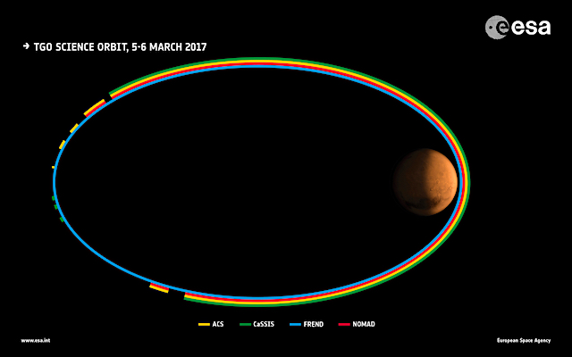
The Trace Gas Orbiter (TGO), a joint endeavour between ESA and Roscosmos, arrived at Mars on 19 October. During two dedicated orbits in late November, the science instruments made their first calibration measurements since arriving at Mars. These included images of Mars and one of its moons, Phobos, and basic spectral analyses of the martian atmosphere.

At that time, the orbiter was in a highly elliptical path that took it from between 230 and 310 km above the surface to around 98 000 km every 4.2 days.

The main science mission will only begin once it reaches a near-circular orbit about 400 km above the planet’s surface after a year of ‘aerobraking’ – using the atmosphere to gradually brake and change its orbit.

Earlier this year, in preparation for the aerobraking phase, TGO conducted a series of manoeuvres to shift its angle of travel with respect to the planet’s equator to almost 74º. This raised it from a near-equatorial arrival orbit to one that flies over more of the northern and southern hemispheres.

This inclination will provide optimum coverage of the surface for the science instruments, while still offering good visibility for relaying data from current and future landers – including the ExoMars rover scheduled for launch in 2020. [More at link, including video]
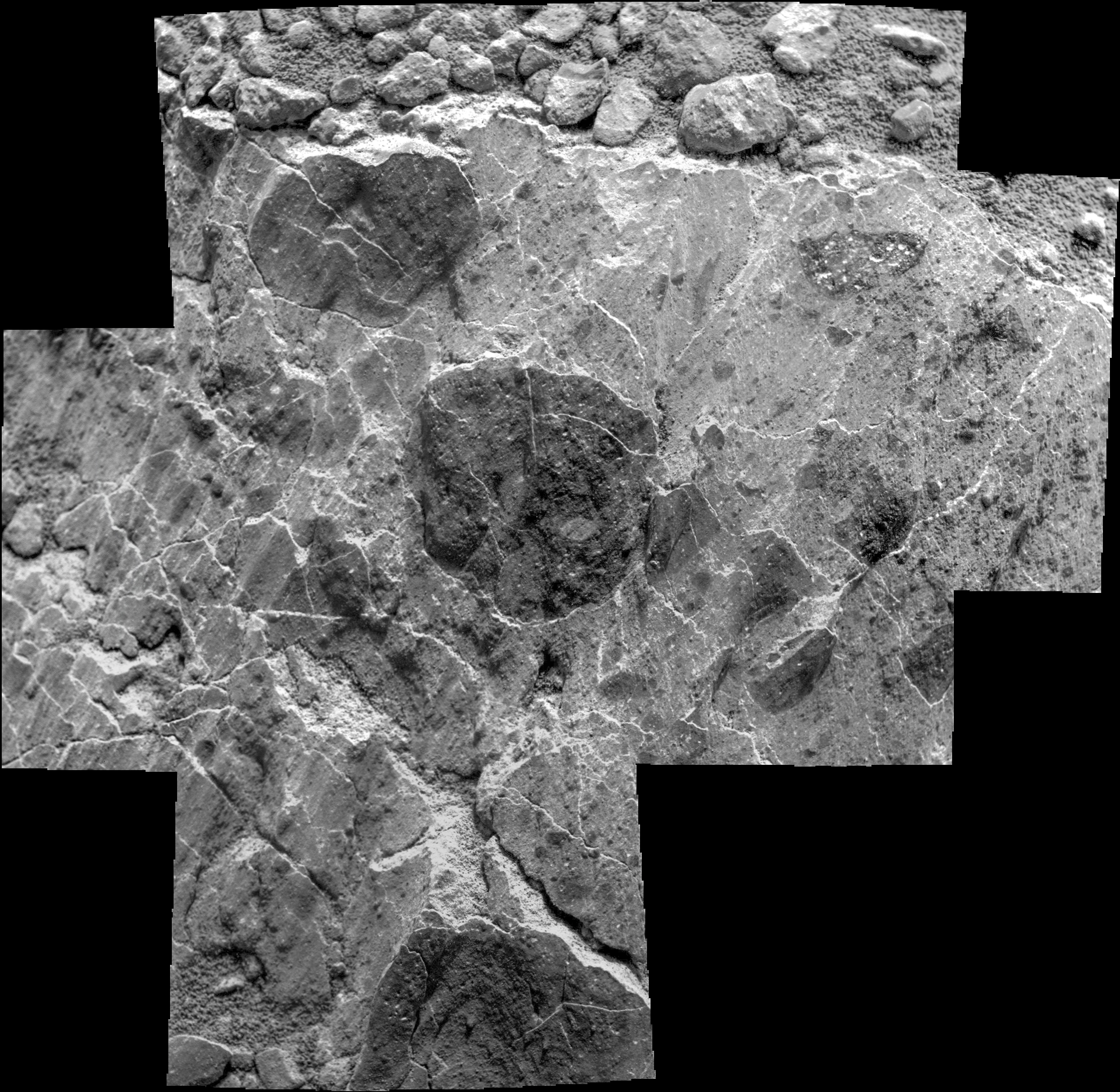
Posted in Reports | Tagged , , , , , | Comments Off

HiRISE: Aeolian erosion textures near Cerberus Fossae

tumblr_olh7faFGt41rlz4gso1_1280Aeolian erosion textures near Cerberus Fossae. Beautiful Mars series.

Posted in Reports | Tagged , , , , , , , , | Comments Off

THEMIS: Lava rough and smooth on Daedalia Planum

Daedalia lava flows rough and smooth (THEMIS_IOTD_20170227)THEMIS Image of the Day, February 27, 2017. his VIS image shows a small portion of Daedalia Planum. The lava flows in this region originated at Arsia Mons, one of the large Tharsis volcanoes. Several different elevations of lava flow are visible in this image, some much smoother in appearance than others.

More THEMIS Images of the Day by geological topic.

Posted in Reports | Tagged , , , , , , , , | Comments Off