Curiosity update: Finishing at Stop 1

NLB_539716750EDR_F0603162NCAM00207M_-br2
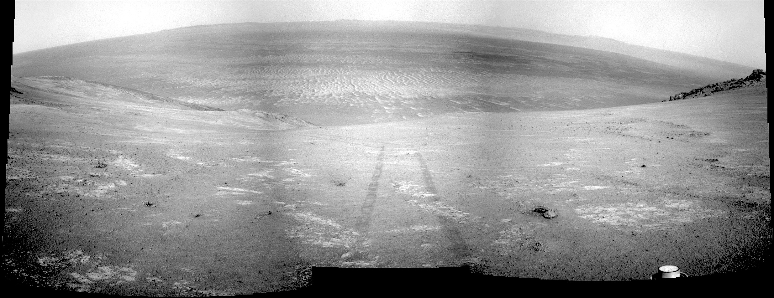
Sol 1603, February 9, 2017, update by USGS scientist Ryan Anderson: Yesterday’s plan went well, and ChemCam has run all of the planned diagnostics and will be back in action tomorrow! Similar to yestersol’s plan, the Sol 1603 plan begins with a pair of Mastcam observations which will be repeated throughout the day to look for any changes in the nearby sand. Mastcam also has multispectral observations of targets “Matagamon,” “Scarboro,” and “Flume Ridge”. Next, Mastcam has a mosaic of some interesting sand ripples. We will wrap up the early afternoon science block with Mastcam atmospheric observations and a… [More at link]

Posted in Reports | Tagged , , , , , , , , , , , , , , , | Comments Off

Opportunity: Making tracks for the rim

4637-navcam1P539846617EFFCVRPP2539L5M1_L2L5L5L7L7Sol 4637, February 8, 2017. After a 13-meter (40-foot) uphill drive on Sol 4636, Opportunity is nearly at the head of the shallow valley that leads to the crest of the Cape Tribulation rim segment. The Navcam view above shows the rover’s tracks and a rock (right center) dubbed Weston.

At right, a false-color Pancam view of Weston (by Holger Isenberg) shows that the rock’s composition differs from the bedrock exposures nearby. Also, Weston appears to be the source for a tail of weathering debris trickling downhill to the left, and at bottom center of the image lies a small clump of fragments (?) with the same color and perhaps composition as Weston. (Click either image to enlarge it.)

Opportunity raw images, its latest mission status, a location map, and atmospheric opacity, known as tau.

Posted in Reports | Tagged , , , , , , , | Comments Off

HiRISE: 9-km impact crater and its central peak

ESP_048173_1930This image reveals an impact crater, nine kilometers in diameter, with a central peak. Impact craters of various sizes and ages can be found across the Martian surface. Each impact crater on Mars possesses a unique origin and composition, which makes the HiRISE team very interested in sampling as many of them as possible!

Like the impact of a droplet into fluid, once an impact has occurred on the surface of Mars, an ejecta curtain forms immediately after, contributing to the raised rim visible at the top of the crater’s walls. After the formation of the initial crater, if it is large enough, then a central peak appears as the surface rebounds. These central peaks can expose rocks that were previously deeply buried beneath the Martian surface. [More at link]

Posted in Reports | Tagged , , , , , , , | Comments Off

MRO: Looking for landing sites

PIA21267At an international workshop this week about where NASA’s next Mars rover should land, most of the information comes from a prolific spacecraft that’s been orbiting Mars since 2006.

Observations by NASA’s Mars Reconnaissance Orbiter (MRO) provide the basis for evaluating eight candidate landing sites for the Mars 2020 rover mission. The landing site workshop this week in Monrovia, California, will narrow the Mars 2020 candidate list to four or fewer sites. MRO observations have been used to identify, characterize and certify past landing sites and are also in use to assess possible sites for future human-crew missions.

“From the point of view of evaluating potential landing sites, the Mars Reconnaissance Orbiter is the perfect spacecraft for getting all the information needed,” said the workshop’s co-chair, Matt Golombek of NASA’s Jet Propulsion Laboratory, Pasadena, California. “You just can’t overstate the importance of MRO for landing-site selection.” [More at link]

Posted in Reports | Tagged , , , , , , , , , | Comments Off

THEMIS: Coprates Chasma, in false colors

False colors in Coprates Chasma (THEMIS_IOTD_20170209)THEMIS Image of the Day, February 9, 2017. Today’s false color image shows part of Coprates Chasma, one of the sub-canyons making up the equatorial rift system named Valles Marineris.

The THEMIS VIS camera contains 5 filters. The data from different filters can be combined in multiple ways to create a false color image. These false color images may reveal subtle variations of the surface not easily identified in a single band image.

More THEMIS Images of the Day by geological topic.

Posted in Reports | Tagged , , , , , , , , | Comments Off

MARCI weather report, Jan 30-Feb 5, 2017

jan-31-2017Continued local-scale dust storm activity across many regions of the northern hemisphere of Mars this past week. The Acidalia storm-track was active with short-lived dust storms on most afternoons. Looking towards the other northern lowlands, Amazonis, Utopia, and eastern Elysium were also busy with small dust storms. The north polar hood has started to reveal some ground frost on a number of crater walls and rims where the atmospheric feature was less optically thick. The southern highlands continued to be relatively uneventful by comparison. Dust clouds and hazes from Acidalia storm-track activity were observed near Argyre and over western Noachis Terra. [More at link, including video]

Posted in Reports | Tagged , , , , , , , , , , , , , | Comments Off

Curiosity: Zooming in on Bagnold sands

1603MH0005550010602024C00_DXXXSol 1603, February 8, 2017. Three MAHLI views of one patch of Bagnold Dunes sand.

As the instrument steps in, each successive image lies nested in the center of the previous one. The final view at bottom shows well-rounded and colorful sand grains in a variety of sizes. Click any image to enlarge it.

1603MH0005490010602038C00_DXXXSol 1603 raw images (from all cameras), and Curiosity’s latest location.

1603MH0005620010602049C00_DXXX

Posted in Reports | Tagged , , , , , , , , , | Comments Off

How Mars got its layered north polar cap

mars-north-polar-cap-800x600

One of Mars’s most striking features is the giant dome of layered ice and dust at its northern pole, analogous to Earth’s ice sheets. Scientists have long debated what formed this dome, thought to have begun developing about 5 million years ago, as well as a much older dome at the south pole. In a new study [published in Geophysical Research Letters], researchers have linked the layers within the northern cap to climatic shifts caused by variations in the planet’s orbit.

Since 1972, when the first close-up image of Mars’s polar caps was captured by the Mariner 9 spacecraft, researchers have debated what mechanisms built them. (…)

In recent years, the High Resolution Imaging Science Experiment (HiRISE) on board NASA’s Mars Reconnaissance Orbiter has made it possible to digitally reconstruct those complex layers…. Now, by analyzing the differences in shape, steepness, and brightness of the icy layers exposed in these trough walls of the northern cap, Becerra et al. have found recurring characteristics in the virtual cores that had not been detected before.

By comparing these regular shifts to distinct, periodic alterations in the orbit and rotation angle of Mars as it circles around the Sun, the team now believes they have solid observational evidence that the emplacement of the icy layers was influenced by orbital changes that occur every 50,000 to 120,000 years and cause periodic shifts in the planet’s climate. [More at links]

Posted in Reports | Tagged , , | Comments Off

HiRISE: Cluster of recent impacts

ESP_047768_1995The dark spots in this enhanced-color infrared image are the recent impact craters that occurred in the Tharsis region between 2008 and 2014. These impact craters were first discovered by the Mars Context Camera (or CTX, also onboard the Mars Reconnaissance Orbiter) as a cluster of dark spots. The meteoroid that formed these craters must have broken up upon atmospheric entry and fragmented into two larger masses along with several smaller fragments, spawning at least twenty or so smaller impact craters.

The dark halos around the resulting impact craters are a combination of the light-toned dust being cleared from the impact event and the deposition of the underlying dark toned materials as crater ejecta. The distribution and the pattern of the rayed ejecta suggests that the meteoroid most-likely struck from the south (which is up in the cutout). [More at link]

Posted in Reports | Tagged , , , , , , , , | Comments Off

THEMIS: Thaumasia Planum in false color

Thaumasia Planum in false color (THEMIS_IOTD_20170208)THEMIS Image of the Day, February 8, 2017. Today’s false color image shows part of the plains of Thaumasia Planum.

The THEMIS VIS camera contains 5 filters. The data from different filters can be combined in multiple ways to create a false color image. These false color images may reveal subtle variations of the surface not easily identified in a single band image.

More THEMIS Images of the Day by geological topic.

Posted in Reports | Tagged , , , , , , , , , , , | Comments Off