Curiosity update: Bagnold Dunes 2: Electric Boogaloo

NLB_539621513EDR_F0603162NCAM00260M_-br2Sol 1602, February 7, 2017, update by USGS scientist Ryan Anderson: The weekend plan went well and today we begin the second half of the campaign to study the “Bagnold Dunes”.

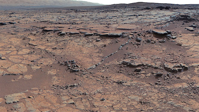
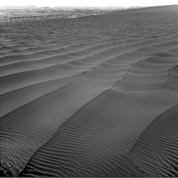
The Sol 1602 plan starts off with two Mastcam mosaics of the dunes which will be repeated several times later in the sol to watch for changes. Navcam also has a dust devil monitoring observation in the morning science block.

Around midday, Mastcam will do a couple of measurements to determine the amount of dust in the atmosphere, and ChemCam will do an active LIBS observation of the soil target “Mapleton” as the final step in the diagnostics that will allow it to return to active duty! In addition to change detection, Mastcam has a stereo image of some bedforms at “Flume Ridge,” a 9×2 mosaic of the… [More at link]

Posted in Reports | Tagged , , , , , , , , , , , , , , , , | Comments Off

ExoMars: Angling up for Mars science

ExoMars2016_TGO_Cruise_In_Orbit_20150625_1280ESA’s latest Mars orbiter has moved itself into a new path on its way to achieving the final orbit for probing the Red Planet.

The ExoMars Trace Gas Orbiter arrived last October on a multiyear mission to understand the tiny amounts of methane and other gases in the atmosphere that could be evidence for biological or geological activity.

In January, it conducted a series of crucial manoeuvres, firing its main engine to adjust its orbit around Mars. The three firings shifted its angle of travel with respect to the equator to almost 74° from the 7° of its October arrival. This essentially raised the orbit from equatorial to being much more north–south.

The arrival orbit was set so that it could deliver the Schiaparelli lander to Meridiani Planum, near the equator, with good communications.

Once science observations begin next year, the new 74º orbit will provide optimum coverage of the surface for the instruments, while still offering good visibility for relaying data from current and future landers. (…)

The inclination change was also a necessary step for the next challenge: a [13-] months-long ‘aerobraking’ campaign designed to bring the spacecraft to its near-circular final science orbit, at an altitude of around 400 km. [More at link]

Posted in Reports | Tagged , , , , , , | Comments Off

Opportunity field report, February 6, 2017

4633_NNE_modelSol 4633, February 6, 2017; Rover Field Report by Larry Crumpler, MER Science Team & New Mexico Museum of Natural History & Science: Several sols ago Opportunity made it up and past the steepest section of its climb out of Endeavour crater. Slopes that were exceeding 20 degrees or locally more, went to less than 20 degrees. Then in the last couple of drives slopes have dropped a little more.

This is a big relief because Opportunity had been exploring deep inside the Endeavour crater rim where the slopes were approaching the angle of repose of loose materials. It was not entirely certain that it could drive out. There was one place were drives were just digging in because the slopes were too steep. These are slopes that you would have difficulty standing upright on.

The view southwest now and ahead is of the crater rim. Opportunity is about to do the impossible and escape from inside a 22 km impact crater. And the things we just saw down in there have never been seen before. This is natural history exploration at its finest. [More at link]

Posted in Reports | Tagged , , , , , | Comments Off

THEMIS: Basaltic sands in Argyre hills

Dunes of Argyre Planitia (THEMIS_IOTD_20170207)THEMIS Image of the Day, February 7, 2017. Today’s false color image shows several areas of dunes and sand sheets with dune forms between the numerous hills in this region west of Argyre Planitia. Basaltic sand appears dark blue in this false color image.

The THEMIS VIS camera contains 5 filters. The data from different filters can be combined in multiple ways to create a false color image. These false color images may reveal subtle variations of the surface not easily identified in a single band image.

More THEMIS Images of the Day by geological topic.

Posted in Reports | Tagged , , , , , , , , , | Comments Off

Curiosity findings from Yellowknife Bay sharpen CO2 paradox of ancient Mars climate

PIA17595-16Mars scientists are wrestling with a problem. Ample evidence says ancient Mars was sometimes wet, with water flowing and pooling on the planet’s surface. Yet, the ancient sun was about one-third less warm and climate modelers struggle to produce scenarios that get the surface of Mars warm enough for keeping water unfrozen.

A leading theory is to have a thicker carbon-dioxide atmosphere forming a greenhouse-gas blanket, helping to warm the surface of ancient Mars. However, according to a new analysis of data from NASA’s Mars rover Curiosity, Mars had far too little carbon dioxide about 3.5 billion years ago to provide enough greenhouse-effect warming to thaw water ice.

The same Martian bedrock in which Curiosity found sediments from an ancient lake where microbes could have thrived is the source of the evidence adding to the quandary about how such a lake could have existed. Curiosity detected no carbonate minerals in the samples of the bedrock it analyzed. The new analysis concludes that the dearth of carbonates in that bedrock means Mars’ atmosphere when the lake existed — about 3.5 billion years ago — could not have held much carbon dioxide.

“We’ve been particularly struck with the absence of carbonate minerals in sedimentary rock the rover has examined,” said Thomas Bristow of NASA’s Ames Research Center, Moffett Field, California. “It would be really hard to get liquid water even if there were a hundred times more carbon dioxide in the atmosphere than what the mineral evidence in the rock tells us.” Bristow is the principal investigator for the Chemistry and Mineralogy (CheMin) instrument on Curiosity and lead author of the study being published this week in the Proceedings of the National Academy of Science. [More at links]

Posted in Reports | Tagged , , , , , , , , , , , , , , | Comments Off

Curiosity: Drill brake issue, ChemCam, REMS, and the terrain ahead

20170202_mount_sharp_perspective_sean_doran_labeled[Editor note: Blog post by Emily Lakdawalla, the Planetary Society] Since my last update, the Curiosity mission has developed a better understanding of the problem that prevented them from drilling at Precipice, but its intermittent nature has slowed the development of a workable solution that will allow them to use the drill again. In the meantime, the rover has driven onward, making good use of its other instruments, but unfortunately passing by two locations (Precipice and one other) where drilling would have continued the team’s rhythmic survey of the Murray mudstones.

The rover is now approaching a new band of active sand dunes, different from the ones explored at the northern edge of the dune field, and plans to spend several weeks in dune investigations, using the scoop to sample and deliver sand to CheMin and SAM. (Scooping activities are unaffected by the drill problems.) The time spent at the sand dunes will enable arm engineers to spend time troubleshooting the drill. (…)

Drilling depends upon three motors in the drill. One, the drill spindle mechanism, rotates the drill. Another, the drill percussion mechanism, pounds on an anvil rod behind the drill 30 times a second in order to pulverize the rock below the drill bit. Finally, the drill feed mechanism moves the whole shebang (drill bit, spindle, and percussion components) along a set of linear rails to advance the drill into the ground…. But drilling will not work at all unless the drill feed mechanism can advance the drill into the ground. So this is a serious problem. [More at link]

Posted in Reports | Tagged , , , , , , , , , , , , , , | Comments Off

HiRISE: Interesting terrain in mid-latitude crater

tumblr_oklun4GbX01rlz4gso1_1280Interesting terrain within mid-latitude crater. Beautiful Mars series.

Posted in Reports | Tagged , , , , , , , , | Comments Off

Opportunity report, Sol 4630, by A.J.S. Rayl, The Planetary Society

20170204_14Gullyorbust-Opportunity-MarathonValley-GullyjpgFebruary 5, 2017: Opportunity Celebrates the Big 1-3, Begins 14th Year of Ops!: As people all around Earth partied and watched fireworks signal the launch of 2017, some 45 million miles away the New Year got off to a start that was unprecedented in every good way: the Mars Exploration Rover (MER) mission completed its 13th Earth year of surface operations and Opportunity drove the first overland expedition of the Red Planet into its 14th year, giving the world something to be universally proud of in January.

More than 13 years on Mars on a mission that began as a three-month tour. Talk about right stuff. “I don’t think anyone in 2004 thought that we’d be commanding this bad girl in 2017,” said MER Deputy Principal Investigator Ray Arvidson of Washington University St. Louis. “It’s just truly amazing.”

And Opportunity is not slowing down. In fact, this robot field geologist is on her way to an ancient gully and traversing now some of the most treacherous terrain she has ever encountered to get to what just may be the most significant research site the mission will visit on its quest to “Follow the Water” and find evidence for past environments that once may have been inhabitable.

“This gully has been calling us for years now,” said MER Principal Investigator, Steve Squyres, of Cornell University. “We saw this thing a long time ago and for the longest time I didn’t even dare talk about it, because it seemed so impossibly far off.” [More at link]

Posted in Reports | Tagged , , , , , , , , | Comments Off

THEMIS: Beruri Crater ejecta in false color stripes

Colored stripes of Beruri Crater ejecta (THEMIS_IOTD_20170206)THEMIS Image of the Day, February 6, 2017. Today’s false color image shows the outer rim of Beruri Crater. This image is of the material ejected by the impact along the eastern rim of the crater. The striped color variations show the radial nature of the ejecta emplacement.

The THEMIS VIS camera contains 5 filters. The data from different filters can be combined in multiple ways to create a false color image. These false color images may reveal subtle variations of the surface not easily identified in a single band image.

More THEMIS Images of the Day by geological topic.

Posted in Reports | Tagged , , , , , , , , , | Comments Off

HiRISE: Chaotic terrain in Xanthe Terra

tumblr_okltq7GsLo1rlz4gso2_1280Chaotic terrain in Xanthe Terra. Beautiful Mars series.

Posted in Reports | Tagged , , , , , , , , , | Comments Off