Curiosity: Ireson Hill, in Mastcam color

1598-mastcam100-hill-6kSol 1598, February 3, 2017. Four hours before driving to a position to take the Ireson Hill image seen here, Curiosity used its Mastcam (with the 100mm lens) to shoot an incomplete color portrait of the hill. The reduced-size composite image above is 6,000 pixels wide and 2 MB in file size; click to enlarge it. The highly detailed full-resolution composite image is here; caution: 29 MB file size.

Sol 1598 raw images (from all cameras), and Curiosity’s latest location.

Posted in Reports | Tagged , , , , , , , , , | Comments Off

Curiosity update: Celebrating Sol 1600 with ‘Whiskey’ and ‘Rye’

NRB_539351147EDR_F0602730NCAM00207M_Sol 1600-01, February 3, 2017, update by USGS scientist Lauren Edgar: Wow, 1600 sols on Mars – that is quite an accomplishment!  And we’re at an exciting point in the traverse as we approach the next segment of the Bagnold Dunes.  Curiosity’s weekend plan includes more contact science and driving as we continue to investigate the Murray formation and prepare for observations at the active sand dunes.  This Saturday is a soliday (a day without planning to allow Earth and Mars schedules to sync back up), so we’ll transition from a late slide sol today to early slide sols next week.  The plan begins with additional imaging of “Ireson Hill” to document the bedding geometry and cap rock from a different viewing position.  We’ll also take a Mastcam tau, a Navcam dust devil movie, and a Mastcam image to monitor the rover deck.  Then Curiosity will acquire MAHLI images of two targets: “Whiskey” and “Rye” (hmmm, perhaps some… [More at link]

Posted in Reports | Tagged , , , , , , , , , , , , | Comments Off

HiRISE: Contrasting colors of crater dunes & gullies

ESP_020957_1290Gullies are relatively common features in the steep slopes of crater walls, possibly formed by dry debris flows, movement of carbon dioxide frost, or perhaps the melting of ground ice.

This example shows a section of crater wall from the rocky crater rim at the far left of the image, down to the dark dusty dunes on the crater floor in the bottom right. (North is to the left.) The rock of the crater walls shows up deep orange, and the sandy deposits on the crater floor and the base of the crater walls appear blue. The sand isn’t really blue; the different colors in this image represent different material compositions. [More at link]

Posted in Reports | Tagged , , , , , , , | Comments Off

Two billion years’ volcanism recorded from a single Mars meteorite ejection site

Mars-Meteorite-for-CMSAnalysis of a Martian meteorite found in Africa in 2012 has uncovered evidence of at least 2 billion years of volcanic activity on Mars. This confirms that some of the longest-lived volcanoes in the solar system may be found on the Red Planet.

Shield volcanoes and lava plains formed from lava flowing over long distances, similar to the formation of the Hawaiian Islands. The largest Martian volcano, Olympus Mons, is nearly 17 miles high. That’s almost triple the height of Earth’s tallest volcano, Mauna Kea, at 6.25 miles.

Tom Lapen, a geology professor at the University of Houston and lead author of a paper published Feb. 1 in the journal Science Advances, said the findings offer new clues to how the planet evolved and insight into the history of volcanic activity on Mars. (…)

Something slammed into the surface of Mars 1 million years ago, hitting a volcano or lava plain. This impact ejected rocks into space. Fragments of these rocks crossed Earth’s orbit and fell as meteorites.

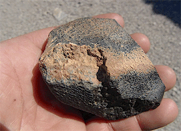
The meteorite, known as Northwest Africa 7635 and discovered in 2012, was found to be a type of volcanic rock called a shergottite. Eleven of these Martian meteorites, with similar chemical composition and ejection time, have been found.

“We see that they came from a similar volcanic source,” Lapen said. “Given that they also have the same ejection time, we can conclude that these come from the same location on Mars.” [More at links]
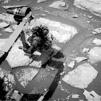
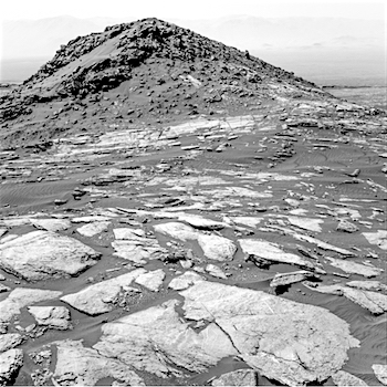
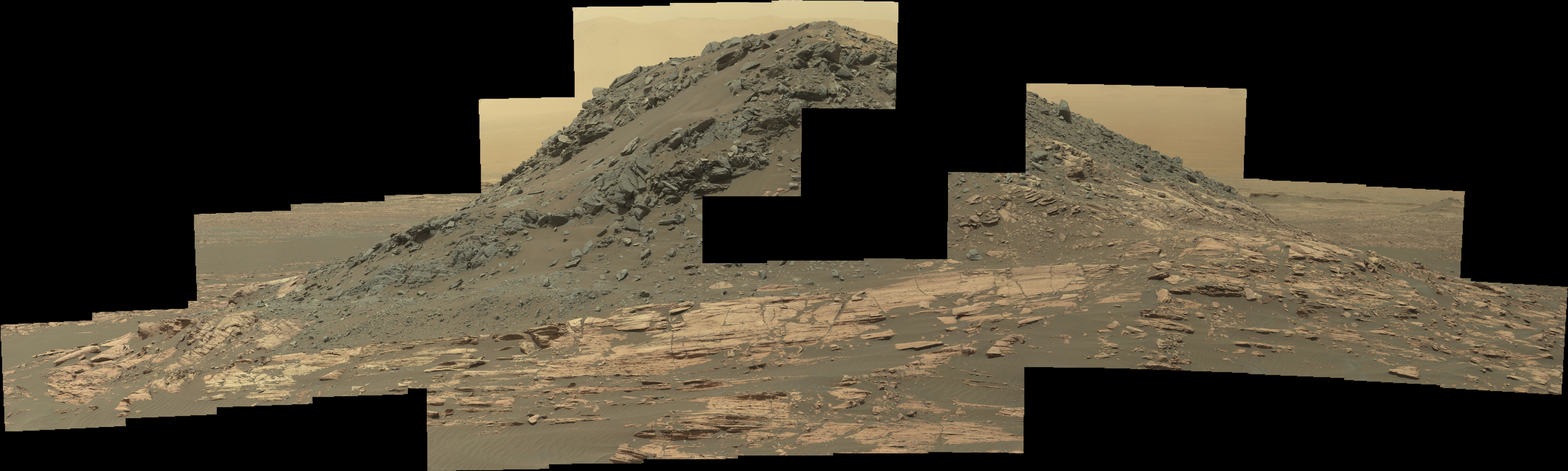
Posted in Reports | Tagged , , , , , | Comments Off

Curiosity: Rounding Ireson Hill

1598-navcam-hillSol 1598, February 3, 2017. Curiosity’s course has taken it around Ireson Hill for a close look at the feature’s south side, where the hill’s sediments appear to have slumped. The wave-like sand dunes at right center suggest that winds have swirled turbulently around the hill. Click image to enlarge it.

Sol 1598 raw images (from all cameras), and Curiosity’s latest location.

Posted in Reports | Tagged , , , , , , , , , | Comments Off

HiRISE: Hard knocks in Tyrrhena Terra

ESP_021716_1685This enhanced-color image shows a small portion of a dark crater floor in the Tyrrhena Terra region of Mars. This is largely ancient hard bedrock that has been cratered by numerous impacts over the eons.

Two other interesting geological features in Tyrrhena Terra (not pictured here): Herschel Crater and Tyrrhena Patera, one of the oldest volcanoes on Mars. [More at link]

Posted in Reports | Tagged , , , , , , , , | Comments Off

THEMIS: Young crater ejecta crosses ridge

Young crater ejecta - south (THEMIS_IOTD_20170203)THEMIS Image of the Day, Febraur 3, 2017. This VIS image shows the same young crater from earlier this week. In this image, covering the area to the south of the young crater, we can see how the thin radial ejecta has lapped up and over the ridge at the bottom of the image.

More THEMIS Images of the Day by geological topic.

Posted in Reports | Tagged , , , , , , , , , | Comments Off

HiRISE: Phantom lands of Mars

tumblr_oklubtQHri1rlz4gso1_1280Phantom lands of Mars. Beautiful Mars series.

Posted in Reports | Tagged , , , , , , , , , , | Comments Off

MEX: Swirling spirals at the north pole of Mars

Perspective_view_of_Mars_north_polar_ice_capA new mosaic from ESA’s Mars Express shows off the Red Planet’s north polar ice cap and its distinctive dark spiralling troughs.

The mosaic was generated from 32 individual orbit ‘strips’ captured between 2004 and 2010, and covers an area of around a million square kilometres.

The ice cap is a permanent fixture, but in the winter season – as it is now in early 2017 – temperatures are cold enough for around 30 percent of the carbon dioxide in the planet’s atmosphere to precipitate onto the cap, adding a seasonal layer up to a metre thick.

During the warmer summer months most of the carbon dioxide ice turns directly into gas and escapes into the atmosphere, leaving behind the water-ice layers.

Strong winds are thought to have played an important role in shaping the ice cap over time, blowing from the elevated centre towards its lower edges and twisted by the same Coriolis force that causes hurricanes to spiral on Earth. [More at link]

Posted in Reports | Tagged , , , , , , , , , , | Comments Off

Curiosity update: Imaging Ireson Hill

NRB_539185942EDR_F0602730NCAM00255M_Sol 1598-99 January 30, 2017, update by USGS scientist Lauren Edgar: The drive on Sol 1598 went well, and Curiosity drove ~21 m to the southwest, providing a great view of “Ireson Hill,” seen in the above Navcam image.  Today’s two-sol plan looks pretty similar to the last.  We’ll start with MAHLI and APXS of the target “Digdeguah” to investigate typical local bedrock with some exposed stratification.  Then ChemCam will continue its recovery activities with an RMI observation of the titanium calibration target.  We’ll use Mastcam to acquire a large mosaic of “Ireson Hill” to characterize the contact and color variations exposed on the south side of this feature. [More at link]

Posted in Reports | Tagged , , , , , , , , , , , | Comments Off