Curiosity: Northwest exposure

1589-mastcam
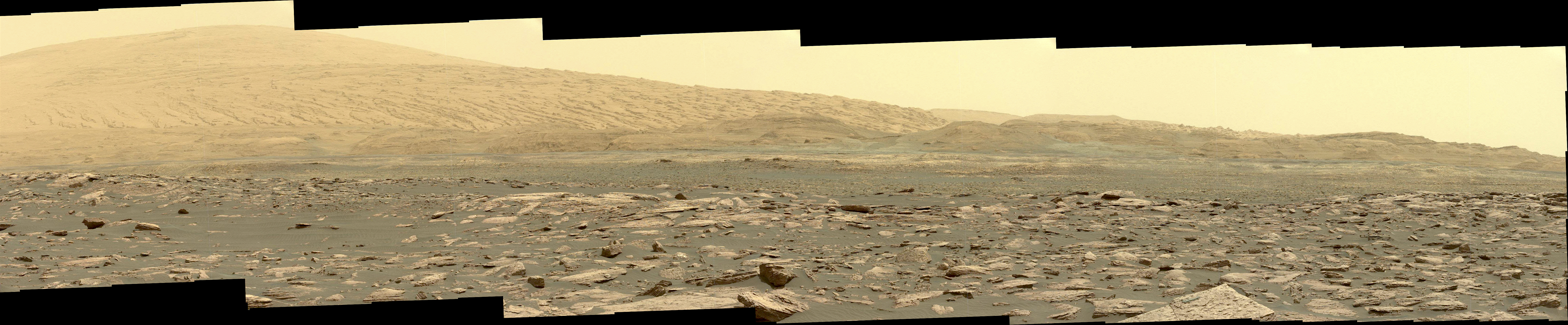
Sol 1589, January 24, 2017. Six Mastcam images (34mm lens) composited into a single view reveal the sweep of Mt. Sharp’s northwest-facing side with its multitude of layers.  Click image (5 MB) to enlarge it.
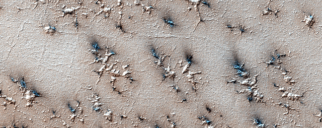
Sol 1589 raw images (from all cameras), and Curiosity’s latest location.

Posted in Reports | Tagged , , , , , , | Comments Off

HiRISE: Pits and channels of Hebrus Valles

ESP_048036_2025The drainages in this image are part of Hebrus Valles, an outflow channel system likely formed by catastrophic floods.

Hebrus Valles is located in the plains of the Northern lowlands, just west of the Elysium volcanic region. Individual channels range from several hundred meters to several kilometers wide and form multi-threaded (anastamosing) patterns. Separating the channels are streamlined forms, whose tails point downstream and indicate that channel flow is to the north. The channels seemingly terminate in an elongated pit that is approximately 1875 meters long and 1125 meters wide. Using the shadow that the wall has cast on the floor of the pit, we can estimate that the pit is nearly 500 meters deep. [More at link]

Posted in Reports | Tagged , , , , , , , , | Comments Off

Curiosity update: Early wheel check-up

1589MR0080950020800423E01_DXXX-br2Sol 1591-92 January 25, 2017, update by USGS scientist Ryan Anderson: The Sol 1589-1590 plan went well, with a successful ~31 meter drive. ChemCam remains “sick” and some diagnostic activities are being planned for the weekend plan. We are approaching the Bagnold Dunes, so in order to save time and allow more room for science activities at the dunes, today’s plan does not include a drive. Instead, we will do a MAHLI check-up of the wheels. Before checking on the wheels, the Sol 1591 plan starts with APXS and MAHLI of the bedrock… [More at link]

Posted in Reports | Tagged , , , , , , , , , , , , , , , | Comments Off

THEMIS: Grazing light at sunrise on lava flows

Layers on layers of lava in Daedalia (THEMIS_IOTD_20170126)THEMIS Image of the Day, January 26, 2017. The grazing light of sunrise, coming from the right, reveals edges and other details in lava flows of Daedalia Planum. These flows come from Arsia Mons volcano. A windstreak is visible at the top of the image, downwind from a small crater.

More THEMIS Images of the Day by geological topic.


Posted in Reports | Tagged , , , , , , , , , , , | Comments Off

Blade-like ridges on Mars have diverse origins

PIA21264_hiresThin, blade-like walls, some as tall as a 16-story building, dominate a previously undocumented network of intersecting ridges on Mars, found in images from NASA’s Mars Reconnaissance Orbiter.

The simplest explanation for these impressive ridges is that lava flowed into pre-existing fractures in the ground and later resisted erosion better than material around them.

A new survey of polygon-forming ridges on Mars examines this network in the Medusae Fossae region straddling the planet’s equator and similar-looking networks in other regions of the Red Planet.

“Finding these ridges in the Medusae Fossae region set me on a quest to find all the types of polygonal ridges on Mars,” said Laura Kerber of NASA’s Jet Propulsion Laboratory, Pasadena, California, lead author of the survey report published this month in the journal Icarus.

The pattern is sometimes called boxwork ridges. Raised lines intersect as the outlines of multiple adjoining rectangles, pentagons, triangles or other polygons. Despite the similarity in shape, these networks differ in origin and vary in scale from inches to miles. [More at links]

Posted in Reports | Tagged , , , , , , , , , , | Comments Off

Mars mantle models pave way for InSight lander

figure_8When NASA’s Interior Exploration using Seismic Investigations, Geodesy and Heat Transport (InSight) lander touches down on Mars in November 2018, it will become the planet’s most advanced geophysical monitoring station. From its landing site on the plains of Elysium Planitia, the craft will attempt to probe the inner depths of the planet with its suite of instruments.

InSight’s goal is to reconstruct how rocky planets like Mars — and Earth — form. One of its most important objectives (to be performed with the Heat Flow and Physical Properties Probe developed at the German Aerospace Center) will be measuring how much heat rises from the planet’s mantle to the surface. This heat, produced by the decay of radiogenic elements, has been building and escaping to the surface since Mars was forged in the early solar system. Knowing the planet’s global average heat flux will help scientists determine the composition and structure of its interior and constrain different models of planet formation.

But to make a truly global measurement, InSight will need some help. It’s not a rover: It will remain stationary, and thus, its heat flux readings will be heavily biased if, for example, it happens to land atop an enormous mantle plume stretching out below the Elysium Mons volcano, roughly 1500 kilometers to the north. To generalize its findings to the rest of the planet, scientists must rely on computer models that simulate how heat flows up through the mantle and crust to the surface.

To that end, Plesa et al. [in the Journal of Geophysical Research] have produced the most detailed simulations to date. They’re the first to use 3-D thermal evolution models with crustal thickness changes across the planet based on gravity and topographical data. These models are combined with an inference of residual radioactivity in the rock of the crust, which also emits heat that makes its way to the surface. Such residual radioactivity wouldn’t be unprecedented: Patches of radioactivity near the Apollo 15 landing site caused surface heat flux readings to be an estimated 2–4 times higher than elsewhere on the Moon. [More at links]

Posted in Reports | Tagged , , , , , | Comments Off

MARCI weather report, January 16-22, 2017

jan-18-2017Martian weather this past week was highlighted by the onset of the Northern hemisphere mid-winter/ Southern hemisphere mid-summer cross-equatorial regional dust storms. This part of the regional storm season on Mars is denoted by local storms that develop in the northern mid-latitudes and travel southwards across the equator along several storm-tracks into the southern low-to-mid latitudes where they can develop into massive regional-scale storms transporting surface dust to heights above 40 km altitude. None of these storms observed this past week were of the scale and duration necessary to transport dust into the mid-atmosphere. The week began with a local dust storm that was spotted over southern Chryse, this storm pushed southward towards Margaritifer Terra by the… [More at link, including video]

Posted in Reports | Tagged , , , , , , , , , , , , , | Comments Off

Did bursts of methane warm early Mars?

figure_3The presence of water on ancient Mars is a paradox. There’s plenty of geographical evidence that rivers periodically flowed across the planet’s surface. Yet in the time period when these waters are supposed to have run — three to four billion years ago — Mars should have been too cold to support liquid water.

So how did it stay so warm?

Researchers from the Harvard John A. Paulson School of Engineering and Applied Sciences (SEAS) suggest that early Mars may have been warmed intermittently by a powerful greenhouse effect. In a paper published in Geophysical Research Letters, researchers found that interactions between methane, carbon dioxide and hydrogen in the early Martian atmosphere may have created warm periods when the planet could support liquid water on the surface.

“Early Mars is unique in the sense that it’s the one planetary environment, outside Earth, where we can say with confidence that there were at least episodic periods where life could have flourished,” said Robin Wordsworth, assistant professor of environmental science and engineering at SEAS, and first author of the paper. “If we understand how early Mars operated, it could tell us something about the potential for finding life on other planets outside the solar system.” [More at links]

Posted in Reports | Tagged , , , | Comments Off

THEMIS: Crater channels, gullies, dunes & a pit

Crater channels gullies and dunes (THEMIS_IOTD_20170125)THEMIS Image of the Day, January 25, 2017. This VIS image shows part of an unnamed crater in Terra Cimmeria. The crater rim is dissected by gullies, and the central pit has several channels entering from the higher elevation of the crater floor. Dunes are also visible in the crater pit. The dark tone of the dunes suggests they are free of dust and therefore likely moveable by the wind.

More THEMIS Images of the Day by geological topic.

Posted in Reports | Tagged , , , , , , , , , , , , | Comments Off

HiRISE: How gas carves channels

ESP_046845_0975A layer of dry ice covers the South Polar layered deposits every winter. In the spring, gas created from heating of the dry ice escapes through ruptures in the overlying seasonal ice, entraining material from the ground below. The gas erodes channels in the surface, shown in this image, generally exploiting weaker material.

The ground likely started as polygonal patterned ground (common in water-ice-rich surfaces), and then escaping gas widened the channels. Fans of dark material are bits of the surface carried onto the top of the seasonal ice layer and deposited in a direction determined by local winds. [More at link]

Posted in Reports | Tagged , , , , , , , , | Comments Off