Everything you wanted to know about Martian scoria cones, but were afraid to ask…

figure_1Planetary Geomorphology Image of the Month, January 30, 2017: Petr Brož (Institute of Geophysics, Czech Academy of Science). Volcanism is an important process which shapes the surfaces of all terrestrial planets, and is still active on Earth, Jupiter’s moon Io, and perhaps on Venus.

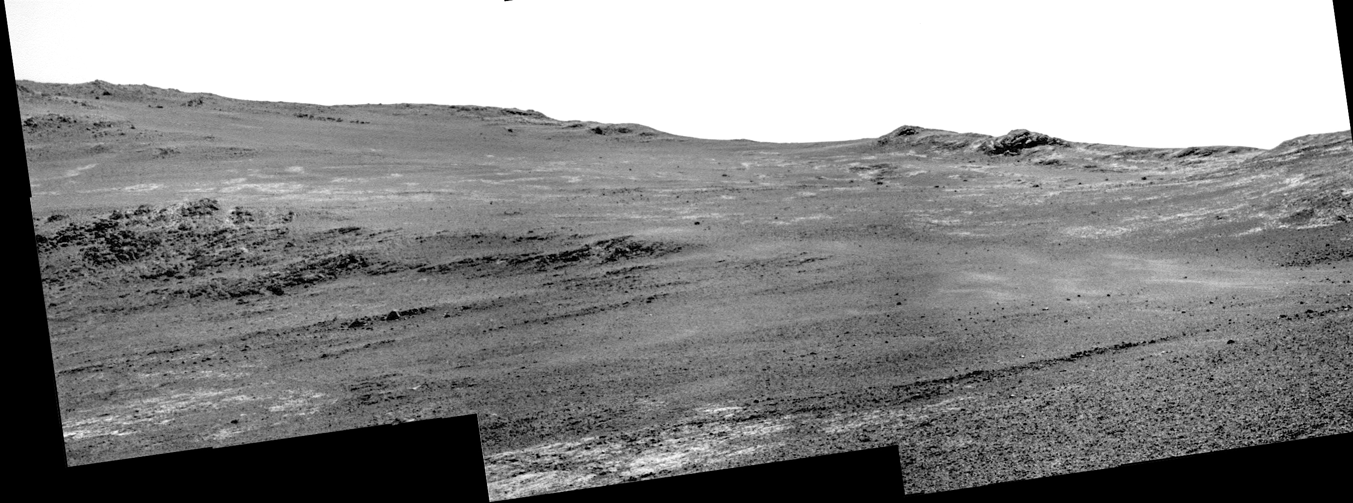
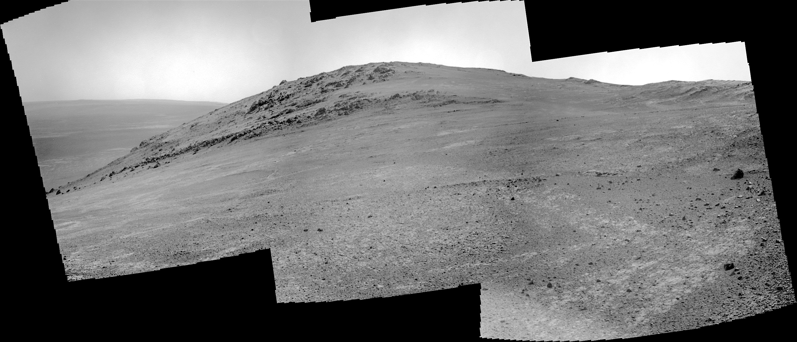
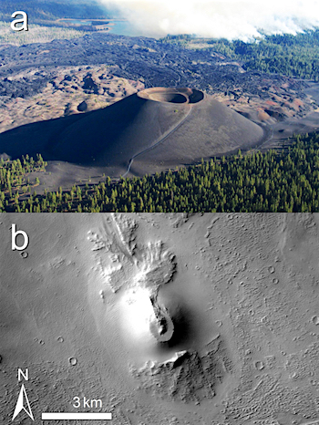
On Earth, volcanoes with wide variety of shapes and sizes exist; however, the size of volcanoes is anti-correlated with their frequency, i.e. small volcanoes are much more numerous than large ones. The most common terrestrial volcanoes are represented by kilometre-sized scoria cones (Figure 1a). These are conical edifices of pyroclastic material originating from explosive volcanic activity. Degassing of ascending magma causes magma fragmentation on eruption piling up the pyroclasts around the vent as a cone.

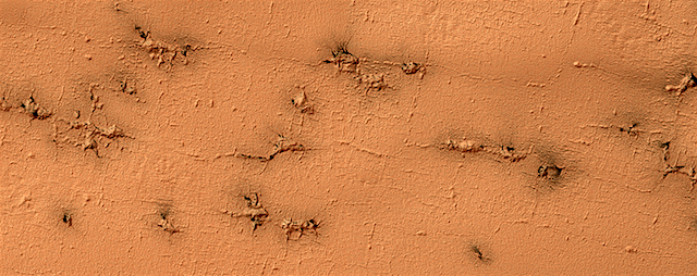
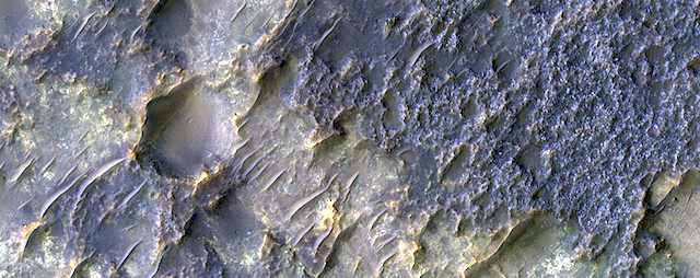
Interestingly, scoria cones as known from Earth, have not been observed commonly on any other terrestrial body in the solar system despite the fact that magma degassing, and hence magma fragmentation, has to occur on these bodies as well. [More at link]

Posted in Reports | Tagged , , , | Comments Off

Opportunity: Southwestward the course

4627-pancam1F538951418EFFCVGZP1214R0M_Sol 4627, January 29, 2017. Rover pilots use the Pancam’s narrower field of view — one-third that of the Navcam — to scout farther ahead in the direction they plan to drive.

Here the Pancam made a three-frame composite of the shallow valley leading to the southwest from the rover’s position on the rim crest.

At right is the view from the front Hazcam, with Mt. Jefferson lying directly ahead and the shallow valley to the right. (Both images enlarge when clicked.)

Opportunity raw images, its latest mission status, a location map, and atmospheric opacity, known as tau.

Posted in Reports | Tagged , , , , , , , | Comments Off

HiRISE: Rectangles with wiggly sides

ESP_048124_0975Ground that has a lot of water ice mixed with dirt tends to crack in polygonal patterns bounded by short straight channels. In the South Polar region of Mars this type of terrain may be covered by a seasonal polar cap composed of dry ice.

In the spring as the seasonal cap sublimates gas is trapped underneath the seasonal ice layer until it can escape to an opening. At this site, faint rectangular channels in the surface are visible. The escaping carbon dioxide gas has exploited these channels and in the process, deepened them and added sinuosity to the formerly straight segments. [More at link]

Posted in Reports | Tagged , , , , , , , , , | Comments Off

Curiosity update: Dead River, Misery, and Boil Mountain?

NRB_538748736EDR_F0602346NCAM00346M_Sol 1593-95 January 27, 2017, update by USGS scientist Lauren Edgar: Looks like the team had some fun using the less desirable names for rock targets in today’s plan!  These are all named after rock formations and geologic features from Bar Harbor, Maine.  MSL drove another 8 meters on Sol 1591, and we’ll continue to drive in the weekend plan.  The three-sol plan starts with a few data management activities for Mastcam and MAHLI, and a recovery sequence to restart ChemCam after it has been marked sick.  Then we’ll take some Mastcam mosaics of “Dead River” and “Boil Mountain” to investigate laminations within the Murray formation and provide some context imaging of the “Misery” outcrop.  Then we’ll use MAHLI and APXS to study “Misery” and… [More at link]

Posted in Reports | Tagged , , , , , , , , , , , , | Comments Off

THEMIS: Field of dunes in Sumgin Crater

Sumgin Crater fields of dunes (THEMIS_IOTD_20170130)THEMIS Image of the Day, January 30, 2017. Today’s VIS image shows sand dunes on the floor of Sumgin Crater. The crater is located in Noachis Terra north of Argyre Planitia. The dunes’ darker tone suggests they are relatively dust-free and likely actively moving under the wind.

More THEMIS Images of the Day by geological topic.

Posted in Reports | Tagged , , , , , , , , , , , , | Comments Off

HiRISE: Interesting texture & thermal properties

tumblr_ok8w9qolaQ1rlz4gso1_1280Interesting texture and thermal properties. Beautiful Mars series.

Posted in Reports | Tagged , , , , , , , , | Comments Off

Opportunity: Gazing at Mt. Jefferson

4625-navcamSol 4625, January 27, 2017. Opportunity has reached the approximate crest of the Cape Tribulation segment of Endeavour Crater’s rim.

Following a 19-meter (61-foot) drive southward, the rover’s Navcam shot a three-frame composite of Mt. Jefferson. This large knob dotted with outcrops lies straight south of Opportunity’s current position, while the Endeavour Crater floor is visible at left.

The mission team is planning to drive Opportunity to the south toward its next major target, a large gully in the rim. The rover’s route to the gully may take it along that shallow valley on the right side of the composite image. Click to enlarge.

Opportunity raw images, its latest mission status, a location map, and atmospheric opacity, known as tau.

Posted in Reports | Tagged , , , , , , , | Comments Off

HiRISE: Youthful dark-rayed crater with boulders

tumblr_ok8vu2du4B1rlz4gso1_1280A youthful dark rayed crater with boulders. Beautiful Mars series.

Posted in Reports | Tagged , , , , , , , , | Comments Off

THEMIS: Morning light on Reull Vallis

Morning light on Reull Vallis (THEMIS_IOTD_20170127)THEMIS Image of the Day, January 27, 2017. Today’s VIS image, made soon after local sunrise, shows a small portion of Reull Vallis. Reull Vallis is one of the major channels entering eastern Hellas Planitia.

More THEMIS Images of the Day by geological topic.

Posted in Reports | Tagged , , , , , , , , , , | Comments Off

HiRISE: Contact between two distinct types of bedrock northwest of Hellas Planitia

ESP_047762_1585In this context image is an old degraded crater that has undergone a complex history of burial and erosion. The image shows a surface with at least two types of exposed bedrock, one that is light-toned and one that is dark. An enhanced color infrared image highlights these two exposures in yellows and blues, which such colors representing altered and unaltered surfaces, respectively.

The overlying, rougher blueish-toned bedrock appears to have undergone the most extensive erosion, revealing the smoother, fractured yellowish-toned bedrock below. We see windblown (aeolian) bedforms across the image, possibly the culprit behind the erosive forces that have removed and uncovered the underlying yellowish-toned bedrock visible today. [More at link]

Posted in Reports | Tagged , , , , , , , | Comments Off