HiRISE: Preserved ejecta and impact melt

ESP_047735_1610This image of a well-preserved unnamed elliptical crater in Terra Sabaea, is illustrative of the complexity of ejecta deposits forming as a by-product of the impact process that shapes much of the surface of Mars.

Here we see a portion of the western ejecta deposits emanating from a 10-kilometer impact crater that occurs within the wall of a larger, 60-kilometer-wide crater. In the central part is a lobe-shaped portion of the ejecta blanket from the smaller crater. The crater is elliptical not because of an angled (oblique) impact, but because it occurred on the steep slopes of the wall of a larger crater. This caused it to be truncated along the slope and elongated perpendicular to the slope. As a result, any impact melt from the… [More at link]

Posted in Reports | Tagged , , , , , , , , | Comments Off

Curiosity update: Another touch and go

NLB_537410481EDR_F0600396NCAM00375M_Sol 1577, January 11, 2017, update by USGS scientist Ken Herkenhoff: MSL drove almost 30 meters on Sol 1576, stopping in a location with a nice exposure of bedrock in the arm workspace.  MAHLI’s optics look clean, so we planned a full suite of MAHLI images and a short APXS integration on a bedrock target named “Mansell Mountain.”  Fitting the remote sensing observations we wanted, along with the contact science and a ~46-meter drive, into the Sol 1577 plan was a challenge.  But the tactical team did a great job, working together to put together an excellent plan.  After the contact science is completed… [More at link]

Posted in Reports | Tagged , , , , , , , , , , , , , | Comments Off

THEMIS: Tectonics in Sirenum Fossae

Faulting in Sirenum Fossae (THEMIS_IOTD_20170112)THEMIS Image of the Day, January 12, 2017. The linear depressions in this VIS image are graben. Graben are formed from tectonic activity with large blocks of material moving downward between paired faults. The crater in the bottom half of the image is oval rather than round, which could have been due to impacting into this region of tectonic deformation.

More THEMIS Images of the Day by geological topic.

Posted in Reports | Tagged , , , , , , , , , , | Comments Off

Seeking signs of life and more: NASA’s Mars 2020 rover mission

nasa-mars-mission-rover-f01Ed. note: The following is an except from a story in Eos, published by the American Geophysical Union. Full story here.

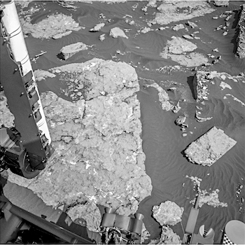
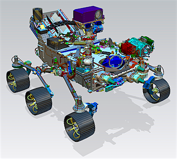
The next Mars rover will be able to land near rugged terrain, giving scientists access to diverse landscapes. It will also cache core samples, a first step in the quest to return samples to Earth.

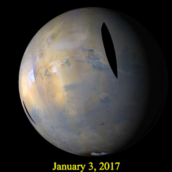
NASA recently confirmed that it plans to fly to Mars in 2020, sending the fifth in a series of increasingly ambitious rovers to investigate the Red Planet. The specific landing site hasn’t been chosen yet, but the Mars 2020 mission will explore one of several possible paleoenvironments older than 3.5 billion years that might once have been conducive to microbial life.

The rover will assess the geology of the landing site and analyze surface targets for signs of ancient life using imaging, organic and inorganic geochemistry, and mineralogy. Notably, the rover, also called Mars 2020, will also be the first to select, collect, and cache a suite of samples from another planet for possible future return to Earth, fulfilling the vision of the most recent planetary science decadal survey to take the first step toward Mars Sample Return [National Research Council, 2011]. (…)

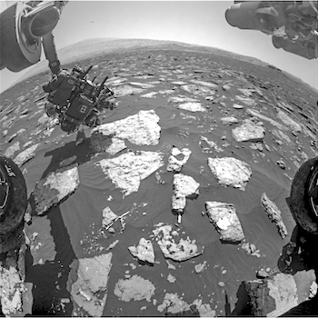
The rover’s scientific instruments will observe the surrounding terrain and provide the critical context for choosing where samples will be collected.

Previous rovers used sophisticated analytic instruments and prepared rock and soil specimens for analysis on board the rover itself. Mars 2020, however, will be the first rover tasked with detailed exploration of the surface to support the collection of a large, high-value sample suite designated for possible later study in laboratories back on Earth. [More at link]
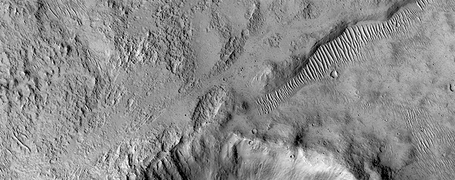
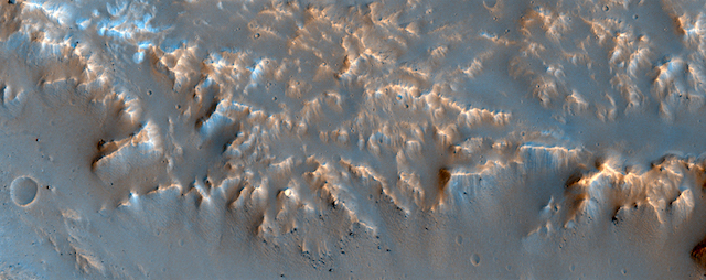
Posted in Reports | Tagged , , , , | Comments Off

HiRISE: Muddy ejecta flow

ESP_046843_1940This small 2 kilometer-wide crater was sitting around, minding its own business when a meteoroid struck the ground just to the west and created a new, larger crater almost 10 kilometers in diameter (not pictured).

The ejecta spraying out of the new crater landed back on the ground and then continued to flow away from the new crater, and the smaller crater was in the way of that muddy flow. You can see where much of the muddy material flowed around the crater’s uplifted rim and forms a squiggly ridge, but you can also see where the mud flow slid over the rim and ponded down in the bottom of the crater. [More at link]

Posted in Reports | Tagged , , , , , , , | Comments Off

Opportunity: Onward and upward

4609-navcamSol 4609, January 10, 2017. After driving 23 meters (75 feet) to the west-northwest, Opportunity used the Navcam to shoot three frames showing the way upslope for the next drive. Click image (1.8 MB) to enlarge it.

Opportunity raw images, its latest mission status, a location map, and atmospheric opacity, known as tau.

Posted in Reports | Tagged , , , , , , , | Comments Off

Curiosity update: Arm fault

FRB_537309558EDR_F0600180FHAZ00190M_Sol 1576, January 10, 2017, update by USGS scientist Ken Herkenhoff: MSL planning started 2 hours later than usual today because the Sol 1575 data needed for planning weren’t expected until almost 10 AM PST.  Unfortunately, the news was not good:  An arm fault prevented the MAHLI full suite from completing, leaving the camera close to the surface with its dust cover open.  The remote science and drive that were planned to follow were also precluded.  Fortunately, this fault has occurred before and is well understood, but recovering from the anomaly made for a rather hectic day for me as SOWG Chair!  The first order of business was to get MAHLI into a safe configuration, so the Sol 1576 plan starts with a single MAHLI image to look for evidence… [More at link]

Posted in Reports | Tagged , , , , , , , , , , , | Comments Off

HiRISE: Wide, branching channels

ESP_047718_0995Southern spring on Mars brings sublimation of the seasonal dry ice polar cap. Gas trapped under the seasonal ice sheet carves channels on its way to escaping to the atmosphere.

At this site, the channels are wider than we see elsewhere on Mars, perhaps meaning that the spider-like (or more scientifically, “araneiform”) terrain here is older, or that the surface is more easily eroded. Seasonal fans of eroded surface material, pointed in two different directions, are deposited on the… [More at link]

Posted in Reports | Tagged , , , , , , , | Comments Off

MARCI weather report, January 2-8, 2017

jan-3-2017There was a slight increase in local-scale dust storm activity this past week on Mars. Short-lived dust storms were observed over Alba, Tempe, Acidalia, and Chryse Planitia. Dust hazes were spotted over Xanthe Terra on the sol following activity over Chryse. Looking west, to the other side of the Tharsis bulge, the plains of Amazonis also experienced a transient dust storm. The southern hemisphere was nearly inactive by comparison. A few tiny dust events, likely kicked up by katabatic winds, were spotted near the south polar ice cap edge. Focusing on the equatorial latitudes, afternoon water-ice clouds were… [More at link]

Posted in Reports | Tagged , , , , , , , , , , , , , | Comments Off

THEMIS: Channels in Noachis Terra craters

Noachis Terra channels (THEMIS_IOTD_20170111)THEMIS Image of the Day, January 11, 2017. This VIS image shows several channels in and around unnamed craters in Noachis Terra. (If the channels look more like tubes or worms, remember that the sunlight is coming from the right side of the image. Craters are round depressions — let them be your guide.)

More THEMIS Images of the Day by geological topic.

Posted in Reports | Tagged , , , , , , , , , | Comments Off