THEMIS: Moreux Crater

Dunes in Moreux Crater (THEMIS_IOTD_20150908)THEMIS Image of the Day, September 8, 2015. The THEMIS VIS camera contains 5 filters. The data from different filters can be combined in multiple ways to create a false color image. These false color images may reveal subtle variations of the surface not easily identified in a single band image. Today’s false color image shows dunes on the floor of Moreux Crater.

More THEMIS Images of the Day by geological topic.

Posted in Reports | Tagged , , , , , , , , , | Comments Off

THEMIS: Iani Chaos – false color

Iani Chaos (THEMIS_IOTD_20150907)THEMIS Image of the Day, September 7, 2015. The THEMIS VIS camera contains 5 filters. The data from different filters can be combined in multiple ways to create a false color image. These false color images may reveal subtle variations of the surface not easily identified in a single band image. Today’s false color image shows part of Iani Chaos.

More THEMIS Images of the Day by geological topic.

Posted in Reports | Tagged , , , , , , , , , | Comments Off

Curiosity update: ‘Laboring away in the Stimson’

1093ML0048440040500338E01_DXXXSol 1095-1098, September 4, 2015, update from USGS scientist Lauren Edgar: As many of us in the U.S. take a break over Labor Day weekend, Curiosity will be keeping busy by using every instrument in her science payload!  Curiosity is currently making her way towards Bridger Basin and studying the Stimson unit along the way.

The weekend 4-sol plan is packed with exciting science.  On Sol 1095, we’ll acquire ChemCam and Mastcam on the targets “Bullwacker,” “Damnation,” and “Bootlegger,” to assess the chemistry of some of the bright bands along fractures and unaltered bedrock.  We’ll also take some Mastcam mosaics to investigate the local geology.  In the evening, SAM will run a diagnostic test, and CheMin will dump the Buckskin sample and analyze an empty cell to prepare for analysis of a future drill sample.  On Sol 1096… [More at link]

Posted in Reports | Tagged , , , , , , , , , , , | Comments Off

Opportunity: Investigating Pvt. Silas Goodrich

1P494567162ESFCO97P2509L5M1_L2L5L5L7L7Sol 4127, September 3, 2015. The Pancam is focusing on an exposed outcrop named Pvt. Silas Goodrich, which shows signs of chemical alteration, probably by water. (The image is a false-color one created by Holger Isenberg.)

Opportunity raw images, its latest mission status, a location map. and atmospheric opacity, known as tau.


Posted in Reports | Tagged , , , , , , , | Comments Off

Curiosity update: ‘Turning in to Bridger Basin’

NLB_494529240EDR_F0492026NCAM00263M_Sol 1094, September 3, 2015, update from USGS scientist Lauren Edgar: The drive on Sol 1093 went well, and Curiosity drove ~15 m towards Bridger Basin.  In the Sol 1094 plan, we’ll drive for ~30 m to round the turn into the basin, as we continue making our way through the Stimson unit.  These rocks exhibit a lot of beautiful cross-bedding, as seen in the Sol 1093 Navcams.

Today’s plan consists of ChemCam and Mastcam observations on the targets “Whitewater” and “Whitefish,” two targets that are within a bright, bleached area near a fracture.  After a short drive, we’ll take standard post-drive imaging to help with targeting in tomorrow’s plan. [More at link]

Posted in Reports | Tagged , , , , , , , , , , | Comments Off

THEMIS: Tectonics

Fractures in Ceraunius Fossae (THEMIS_IOTD_20150904)THEMIS Image of the Day, September 4, 2015. The graben and collapse features in this image are part of Ceraunius Fossae, which is located south of Alba Mons.

More THEMIS Images of the Day by geological topic.

Posted in Reports | Tagged , , , , , , , , , , , , | Comments Off

HiRISE: Steep sloped crater on Meridiani Planum

tumblr_ntlxu9PyJP1rlz4gso2_1280Simply stupendous steep slope Meridiani Planum. Beautiful Mars series.

Posted in Reports | Tagged , , , , , , , , | Comments Off

MAVEN: Deep-dip campaign #4 begins

MVN-deep-dip4MAVEN has successfully entered the fourth deep-dip campaign of the mission. Two maneuvers executed over the past two days have placed the MAVEN spacecraft into a deep-dip corridor, with a periapsis altitude of 121.2 km (75.3 mi), where Mars’ atmospheric density is 2.2 kg/km³. At a periapsis latitude of 65.7ºS, this deep-dip campaign will provide coverage of Mars’ south polar region… [More at link, including video]

Posted in Reports | Tagged , , , , | Comments Off

Opportunity report, Sol 4125, by A.J.S. Rayl, The Planetary Society

20150902_11-Pvt-George-Gibson-Sol4118B-082415-False_L257
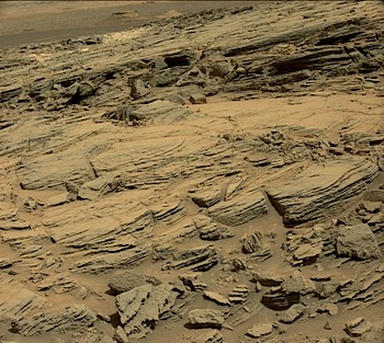
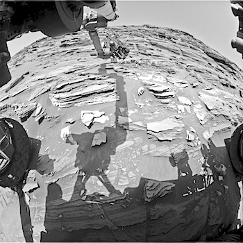
September 3, 2015: Opportunity Digs Marathon Valley Walkabout: Opportunity drove farther into Marathon Valley in August, dug into what appears to be a water-altered rock, and took a lot of picture postcards in what is turning out to be a distinctively different site from any that the Mars Exploration Rovers mission has found since the robot field geologist landed in 2004.

“It’s a place that’s unique relative to where we’ve been before,” said Ray Arvidson, MER deputy principal investigator, of Washington University St. Louis. “This is virgin territory for us.” [...]

Opportunity entered the Marathon Valley last month and is in the midst of a geological walkabout to see what’s there. “The objective is to cover the whole territory pretty comprehensively before winter sets in later this year,” said Steve Squyres, MER principal investigator, of Cornell University. But Marathon Valley is a lot bigger than Matijevic Hill, where the mission made history in 2013 ground-truthing the first clay minerals found by a surface mission on Mars. “So this walkabout will take time,” he said.  [More at link]

Posted in Reports | Tagged , , , , , , | Comments Off

Curiosity update: ‘Leaving the Williams area’

FLB_494434209EDR_F0491876FHAZ00323M_Sol 1093, September 2, 2015, update from USGS scientist Lauren Edgar: After successful contact science on the Stimson unit in the Williams area, it’s time to get back on the road.  In today’s plan we’ll finish up a few activities at the Williams area, and then continue on our drive towards Bridger Basin and eventually the Bagnold Dunes.

Today’s plan consists of ChemCam and Mastcam observations on the targets “Interlake,” “Ledger,” and “Mackay Dome.”  Then we’ll image the “Ledger” target using all of the Mastcam camera filters, and take another Mastcam clast survey image to look for any changes in the time that we’ve been here.  We’ll also use Mastcam to… [More at link]

Posted in Reports | Tagged , , , , , , , , , , , , | Comments Off