CRISM: Iron-magnesium phyllosilicates near rim of Gale Crater

B5A3
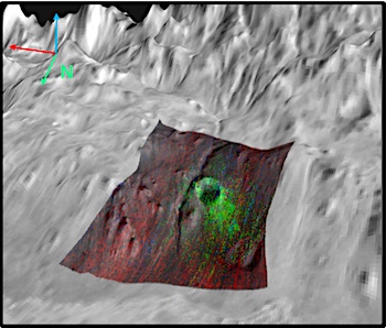
CRISM scene FRT0000B5A3 covers the southern wall of Gale crater, 15 km downslope from the rim. This region is gently sloping, compared to the northern wall, potentially indicating that the Gale basement rocks in the crater rim are mantled by newer material. A fluvial channel also bisects this scene. Fe/Mg phyllosilicates (green) have been exhumed by the central impact crater in this scene. This morphological feature along with the material inside the smaller crater toward the northwest are correlated to mass wasting events in this region of Gale Crater. The Mars Science Laboratory (MSL) Curiosity Rover is investigating the layered materials that make up the large mountain in the middle of Gale Crater. [More at link]

Posted in Reports | Tagged , , , , , , , , , , , | Comments Off

Curiosity: Charting a path forward

2302-navcamSol 2302, January 27, 2019. Curiosity’s Navcam shot a new composite of the scenery ahead, after a sequence of drives totaling a little over 27 meters (88 feet). Click the image to enlarge it.

Sol 2302 raw images (from all cameras).

Posted in Reports | Tagged , , , , , , , , , , | Comments Off

THEMIS: Lava flow fronts in Daedalia Planum

Lava plains of Daedalia (THEMIS_IOTD_20190128)THEMIS Image of the Day, January 28, 2019. Today’s VIS image shows a small portion of the immense lava plains of Daedalia Planum. These flows originated from Arsia Mons, one of the three large Tharsis volcanoes.

See more THEMIS Images of the Day by geological subject.

Posted in Reports | Tagged , , , , , , , , , , | Comments Off

Ocean shoreline in Cydonia Mensae?

figure-1[Editor’s note: From a paper by Steven Sholes and two co-authors recently published in the Journal of Geophysical Research.]

Quantitative High‐Resolution Re‐Examination of a Hypothesized Ocean Shoreline in Cydonia Mensae on Mars

• We apply a proposed paleoshoreline identification toolkit to newer high resolution data of an exemplar site for paleoshorelines on Mars.
• Any wave-generated paleoshorelines should exhibit expressions identifiable in the residual topography from an idealized slope.
• Our analysis of these curvilinear features does not support a paleoshoreline
interpretation, and is more consistent with eroded lithologies.

There is an ongoing controversy about whether Mars had ancient oceans. Abundant evidence for past surface liquid water exists but it is debated how much and for how long it persisted on Mars’ surface.

Features have previously been traced out in relatively low‐resolution images and interpreted as shorelines of episodic ancient oceans. However, new high‐resolution data allows for better and more complete analyses. Here, we present methods to determine whether any proposed ancient shoreline feature meets the requirements to be classified as a shoreline using these improved data.

Shorelines should form flat “step‐like” landforms at a near‐constant elevation, so one critical analysis looks at the shape and elevation of proposed features. We examine a site that has been promoted in the literature as an exemplar of ancient shorelines and find that this site lacks a diagnostic shoreline shape. Instead features at this site are better explained as exposed and eroded rock layers that mimic shoreline shapes in low‐resolution images.

Our findings do not mean that oceans never existed on Mars, only that this specific site does not support the ocean hypothesis. Application of our methods to similar sites could shed further light on the ocean hypothesis. [More at link]

Posted in Reports | Tagged , , | Comments Off

Curiosity: Clay-bearing viewpoint

2299-mastcam34Sol 2299, January 24, 2019. Using its wide-angle (34mm) camera, Curiosity’s Mastcam shot a five-frame view overlooking the reverse slope of Vera Rubin Ridge (foreground and top left).

Mission scientists and engineers are planning to drive Curiosity down off the ridge and onto the clay-bearing unit which lies ahead. This will be the next major geological feature to be explored by the rover. Click the image (6.9 MB) to enlarge it.

Sol 2299 raw images (from all cameras).

Posted in Reports | Tagged , , , , , , , , , , | Comments Off

Opportunity: Over 600 recovery commands have been sent

NASA Mars Exploration Rover Status Report, January 25, 2019: Mars atmospheric opacity (tau) over the rover site is uncertain due to recent storm activity.

No signal from Opportunity has been heard since Sol 5111 (June 10, 2018) during the historic global dust storm. Opportunity likely experienced a low-power fault, a mission clock fault and an up-loss timer fault. The team is continuing to listen for the rover over a broad range of times, frequencies and polarizations using the Deep Space Network (DSN) Radio Science Receiver.

The team is continuing to command “sweep and beeps” throughout each daily DSN pass to address a possible complexity with certain conditions within mission clock fault on the rover. Since loss of signal, over 600 recovery commands have been radiated to the rover. [More at link]

Posted in Reports | Tagged , , , , , , , | Comments Off

Weather at Gale Crater

Posted in Reports | Tagged , , , , , , , | Comments Off

Curiosity update: Beam me up Scotty!

NLA_601599724EDR_F0731944NCAM00258M_-br2Sol 2300, January 24, 2019, update by MSL scientist Lucy Thompson: Curiosity is on the brink of descending down off the Vera Rubin Ridge (VRR) onto the clay-bearing unit. We are hoping to ‘beam up’ lots of interesting new data to the Mars orbiters, to be relayed to Earth after executing our plan on Mars tosol. We planned a typical ‘Touch and Go’ sol today, which includes using the arm to place our contact science instruments (APXS and MAHLI) on a rock target to document chemistry and texture, followed by remote science by ChemCam and Mastcam to also look at chemistry and the larger scale view out the front window, before a drive. We are documenting how the chemistry and appearance of the rock is changing as we transition from the resistant VRR to the less resistant, orbitally distinct clay-bearing unit, and taking larger-scale images and mosaics to assist in future planning of our investigation of the clay-bearing unit… [More at link]

Posted in Reports | Tagged , , , , , , , , , , , , , , | Comments Off

THEMIS: Gullies in Terra Sirenum

Gullies in Terra Sirenum (THEMIS_IOTD_20190125)THEMIS Image of the Day, January 25, 2019. Multiple gullies dissect the rim of an unnamed crater located in Terra Sirenum. Towards the bottom of the image several small gullies are visible located on the rim of an older crater.

See more THEMIS Images of the Day by geological subject.

Posted in Reports | Tagged , , , , , , , , | Comments Off

HiRISE: Cross-section of a complex crater

ESP_058057_1465This image shows a cross-section of a complex crater in Terra Cimmeria.

Starting in the center, we see a series of peaks with exposed bedrock. These peaks formed during the impact event when material that was originally several kilometers below the surface was uplifted and exposed. The impact also melted the rocks. This eventually cooled, forming the pitted materials that coat the crater floor around the uplift.

The rim of the crater was unstable, and collapsed inwards to form terraces, and we see additional pitted materials between the terraces and the rim. Just outside the crater we can see dark-toned material that was excavated and thrown out after the impact. [More at link]

Posted in Reports | Tagged , , , , , , , , , , | Comments Off