HiRISE: Textures in Deuteronilus Mensae

ESP_018515_2225
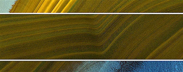
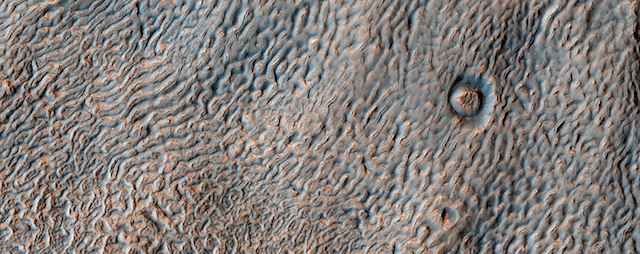
This enhanced color image shows the surface of a lobate debris apron in the Deuteronilus Mensae region of Mars, on the boundary between the Northern plains and Southern lowlands. These lobe-shaped formations commonly emanate from mesas in this region and have pitted, lineated textures that suggest the flow of water ice.

Results from the SHARAD (SHAllow RADar) instrument on MRO indicate that lobate debris aprons in Deuteronilus Mensae, similar to those visible here, are composed of material dominated by ice and are interpreted to be potential debris-covered glaciers or rock glaciers… [More at link]

Posted in Reports | Tagged , , , , , , , , , , , | Comments Off

Curiosity: Higher levels ahead

1822-navcamSol 1822, September 21, 2017. Mission controllers have driven Curiosity about 40 meters (82 feet) drive to the south-southeast. As the Navcam looks ahead, upper surface of Vera Rubin Ridge is revealing stepped layers not far away. These are visible in overhead images from HiRISE, but now they are visible from ground level and will become factors in the rover’s operation plans. Click image to enlarge it.

Sol 1822 raw images (from all cameras), and Curiosity’s latest location.

Posted in Reports | Tagged , , , , , , , , | Comments Off

CRISM: Ice on rim of crater on Alba Mons

Alba Patera_uploadAlba Mons is the largest volcano, by area, on Mars. A low-lying volcano in the northern Tharsis region, Alba Mons has an elevation of 6.8 km, and volcanic flow fields that extend at least 1,350 km from the summit. Alba Mons is one of several areas on Mars that may contain thick deposits of near-surface ice preserved from when the planet’s climate could have allowed mountain glaciers to exist at the mid-latitudes (1 to 10 million years ago). Data collected by the Neutron Spectrometer on Mars Odyssey indicates that the northern flank of Alba Mons might contain up to 7.6% of water-equivalent hydrogen, suggesting the possible presence of water ice today. Since water is not stable on the surface, however, the water would need to be frozen and blanketed by at least 1 m of dust or… [More at link]

Posted in Reports | Tagged , , , , , , , , , | Comments Off

Opportunity continues to survey Perseverance Valley during winter

Opportunity Status Report, September 21, 2017: Opportunity is continuing the winter exploration of “Perseverance Valley” on the west rim of Endeavour Crater.

Winter continues to constrain activity. Sols 4849, 4852 and 4854 (Sept. 13, Sept. 16 and Sept. 19, 2017), were recharge sols with little to no science activity. However, the rover continues to make good progress is surveying the valley.

On Sol 4850 (Sept. 14, 2017), Opportunity collected a 10×1-frame Panoramic Camera (Pancam) stereo panorama. This was continued on Sol 4854 (Sept. 19, 2017), with a 14×1-frame Pancam stereo panorama, filling out the data set for a complete digital elevation model at this location in the valley. The robotic arm was used on Sol 4851 (Sept. 15, 2017), to set up for an early morning test of the Alpha Particle X-ray Spectrometer (APXS) on the morning of Sol 4854 (Sept. 19, 2017). A Microscopic Imager (MI) mosaic was collected prior to the APXS placement. The test of the APXS showed that good quality data can be collected in the winter early morning (versus the normal late night)…  [More at link]

Posted in Reports | Tagged , , , , , , | Comments Off

HiRISE: A world of crater clusters

tumblr_ou48dc6UYV1rlz4gso1_1280A world of crater clusters  — These are in Hesperia Planum. Beautiful Mars series.

Posted in Reports | Tagged , , , , , , , , , | Comments Off

Curiosity update: Onward and upward!

1819ML0093980010702705E01_DXXX-br2Sol 1822, September 21, 2017, update by MSL scientist Lauren Edgar: On Sol 1821, Curiosity successfully completed contact science activities at “Pennessewassee” and “Passadumkeag”. Perhaps in an effort to get to more easily pronounceable rock targets, today’s tactical team planned a nice long drive towards our next waypoint on Vera Rubin Ridge.

The Sol 1822 plan begins with a Navcam movie to look for clouds above the northern rim of the crater. Then Curiosity will turn her attention towards the bedrock targets in front of her, using both Mastcam and ChemCam to assess the spectral character of yesterday’s DRT target “Passadumkeag” and to assess the composition and sedimentary structures exposed at “Hypocrites Ledge.” We’ll also use Mastcam to monitor the movement of fines on the rover deck. Then Curiosity will gear up for a drive of ~40 m, as we work our way… [More at link]

Posted in Reports | Tagged , , , , , , , , , , , | Comments Off

THEMIS: Low hill divides the dunes

Hill amid the dunes of Siton Undae (THEMIS_IOTD_20170921)THEMIS Image of the Day, September 21, 2017. Siton Undae is a large dune field located in the northern plains near Escorial Crater. Siton Undae is west of the crater and is one of three dune fields near the crater. The nearby north polar cap is dissected by Chasma Boreale, which exposes an ice free surface. This image shows a cross section of the dune field. Collected in the early spring season the dunes still retain a frost cover.

NASA’s Mars Odyssey spacecraft has spent over 15 years in orbit around Mars, circling the planet more than 69,000 times. It holds the record for longest working spacecraft at Mars. THEMIS, the IR/VIS camera system, has collected data for the entire mission and provides images covering all seasons and lighting conditions.

Over the years many features of interest have received repeated imaging, building up a suite of images covering the entire feature. From the deepest chasma to the tallest volcano, individual dunes inside craters and dune fields that encircle the north pole, channels carved by water and lava, and a variety of other feature, THEMIS has imaged them all.

For the next several months the Image of the Day will focus on the Tharsis volcanoes, the various chasmata of Valles Marineris, and the major dunes fields. We hope you enjoy these images!

More THEMIS Images of the Day by geological topic.

Posted in Reports | Tagged , , , , , , , , , , , , , , | Comments Off

HiRISE: North polar layers: streaking and unconformity

ESP_018160_2595In geology, an unconformity is a buried erosion surface, where the bedding layers don’t match. It doesn’t mean a mismatch in attitudes and beliefs, with rebellious behavior like streaking. But Mars does have streaking of a different kind, from the wind.

This oblique image of part of the North Polar layered deposits, acquired in the summertime, shows both phenomena in the upper and lower panels, plus a topographic bend in the middle panel. Blue areas in this enhanced color image are covered by frost, whereas the darker colors are from differences in contamination and texture of the icy layers. [More at link]

Posted in Reports | Tagged , , , , , , , , | Comments Off

Curiosity: Nose on the pavement

FRB_559165415EDR_F0660246FHAZ00337M_Sol 1821, September 20, 2017. Curiosity continues its exploration of the bare rock “pavement” on top of Vera Rubin Ridge, as seen in the front and rear Hazcams. (The rear image is speckly with noise.) Click either image to enlarge it.

RRB_559165450EDR_F0660246RHAZ00337M_Sol 1821 raw images (from all cameras), and Curiosity’s latest location.

Posted in Reports | Tagged , , , , , , , , | Comments Off

MARCI weather report, September 11-17, 2017

MARCI-September-15-2017Weather conditions were relatively unchanged from last week. Tiny transient dust storms were spotted northwest of Elysium Mons and southwest of Syrtis near the middle of the week. During that time, frontal dust storms streamed off the seasonal cap over plains near the Phlegra Montes. Diffuse afternoon water-ice clouds associated with the aphelion cloud-belt continued to loom over the topographic highs of… [More at link, including video]

Posted in Reports | Tagged , , , , , , , , , , , , , | Comments Off