Curiosity update: Finishing up at Midland Valley

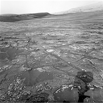
NRA_603465820EDR_F0740540NCAM00280M_-br2Sol 2338, March 4, 2019, update by MSL scientist Rachel Kronyak: Today we planned Sol 2338 chock full of science activities to finish up our observations at the “Midland Valley” outcrop. We’ll primarily use our Mastcam and ChemCam instruments to take a closer look at some interesting rock targets in our workspace.

We’ll kick off our block of science activities on Sol 2338 with a Mastcam mosaic looking ahead of the rover, where the team identified an interesting area of fractured bedrock, pictured in the Navcam image above; we named this target area “Longhope.” After that, we’ll use the ChemCam laser to analyze rock targets “Miller” and “Cuttyhill.” We’ll then take multispectral Mastcam images of targets Cuttyhill and another interesting rock named “Leslie.” After our science observations, we’ll hit the dusty trail and drive… [More at link]

Posted in Reports | Tagged , , , , , , , , , , , , , , , , | Comments Off

THEMIS: Terra Sabaea in false color

Terra Sabaea in false color (THEMIS_IOTD_20190305)THEMIS Image of the Day, March 5, 2019. This false-color image is located between Terra Sabaea and Isidis Planitia basin.

Blue tones in this band configuration indicate basaltic sands. The sands are more prevalent in the plains at the upper frame part of the image, and only occur in limited number of depressions in the bottom half of the image. The underlying reason for the difference may related to sand abundance or sand mobility by the wind.

The THEMIS VIS camera contains 5 filters. The data from different filters can be combined in multiple ways to create a false color image. These false color images may reveal subtle variations of the surface not easily identified in a single band image.

Explore more THEMIS Images of the Day by geological subject.

Posted in Reports | Tagged , , , , , , , , , , | Comments Off

InSight update, Sol 92, by Emily Lakdawalla, The Planetary Society

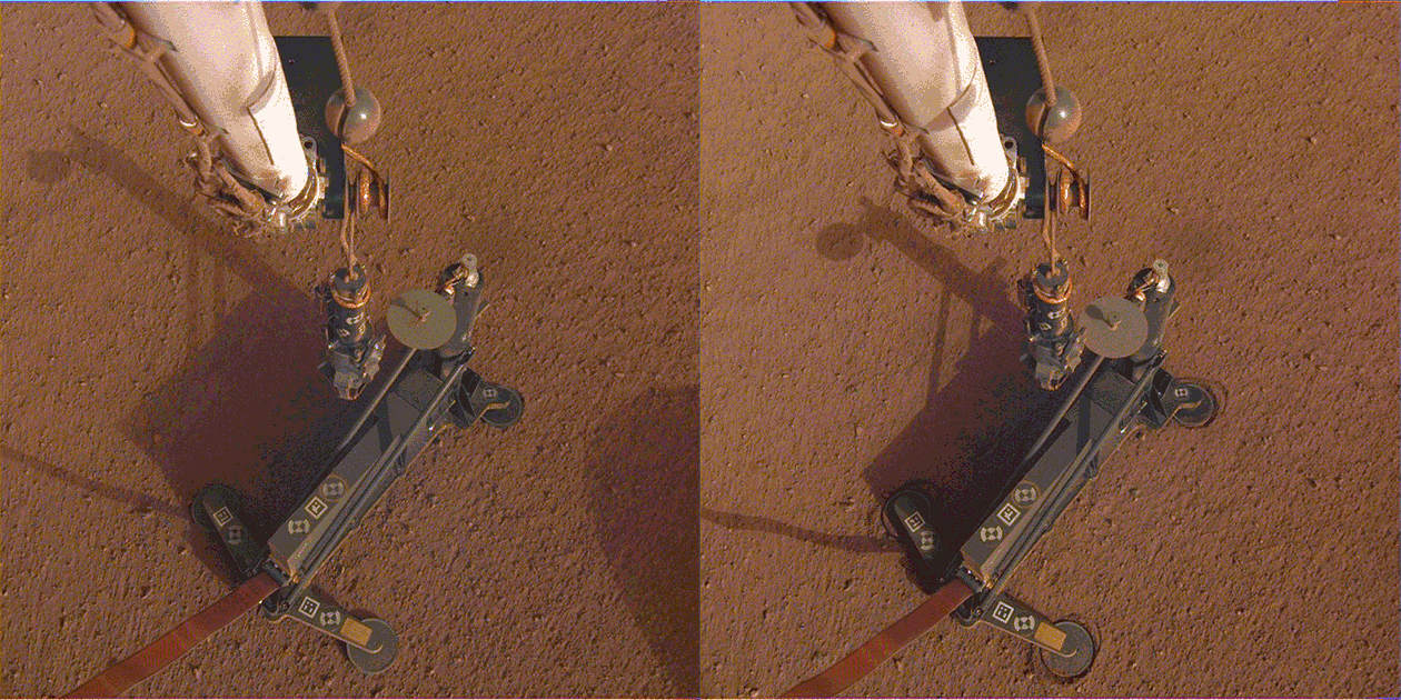
20190302_HP3_first_hammerThe mole did hit a rock. Mars could’ve given us a break, but it didn’t. The HP3 mole started hammering itself today, and almost immediately (after just 5 minutes) appears to have encountered a rock. After four hours of hammering, it may have pushed the rock aside, but doesn’t appear to have buried itself completely beneath the soil yet, because it’s still measuring temperatures consistent with the Martian air temperature. No matter; they’ll… [More at link]

Posted in Reports | Tagged , , , , , , , , , | Comments Off

HiRISE: The slow charm of brain terrain

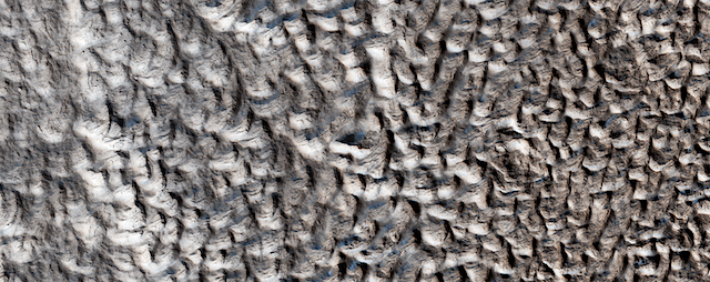
ESP_058008_2225You are staring at one of the unsolved mysteries on Mars. This surface texture of interconnected ridges and troughs, referred to as “brain terrain” is found throughout the mid-latitude regions of Mars. (This image is in Protonilus Mensae.)

This bizarrely textured terrain may be directly related to the water-ice that lies beneath the surface. One hypothesis is that when the buried water-ice sublimates (changes from a solid to a gas), it forms the troughs in the ice. The formation of these features might be an active process that is slowly occurring since HiRISE has yet to detect significant changes in these terrains. [More at link]

Posted in Reports | Tagged , , , , , , , , , , , , | Comments Off

THEMIS: Acidalia Colles in false color

Acidalia Colles (THEMIS_IOTD_20190304)THEMIS Image of the Day, March 4, 2019. This VIS image shows part of Acidalia Colles.

The term colles means hill. Dark blue tones in this band configuration typically identify basaltic sands. This “blue” material is found on the plains, but also on some of the hill faces. Acidalia Colles in located in central Acidalia Planitia.

The THEMIS VIS camera contains 5 filters. The data from different filters can be combined in multiple ways to create a false color image. These false color images may reveal subtle variations of the surface not easily identified in a single band image.

Explore more THEMIS Images of the Day by geological subject.

Posted in Reports | Tagged , , , , , , , , , , , | Comments Off

The banded terrain on Mars

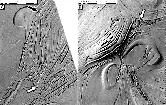
banded-terrain-hellasPlanetary Geomorphology Image of the Month, March 1, 2019: Hannes Bernhardt (Arizona State University). An article on the banded terrain cannot be commenced by a traditional definition, as it appears to be a truly singular occurrence in the Solar System. In a competition for the most mysterious landscapes on Mars, the so called “banded terrain” (Image 1) would certainly be a hot contender – a fact illustrated by one of its other descriptive appellations: “Taffy pull terrain.” It is a strong reminder of the limitations that are intrinsic to remote sensing geology but also of the strengths of comparative geomorphology.

The banded terrain is a unique landscape occupying over 30,000 km² of northwestern Hellas Planitia, the floor of Mars’ largest and deepest impact basin located in the mid-latitudes of its southern hemisphere (Diot et al., 2015; Bernhardt et al., 2019). The banded terrain consists of a smooth surface (at meter-scale) dissected by up to ∼30 m deep, crevice-like, curvilinear troughs (“inter-bands”) at a median spacing of few 100 s of m (Image 1A). These troughs… [More at link]

Posted in Reports | Tagged , , , , | Comments Off

HiRISE: Living on the edge

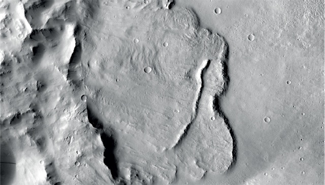
ESP_054641_1455Living on the edge. The rim of this crater looks fairly sharp, meaning it hasn’t degraded too much even though it is likely very old. The exposed, light-toned bedrock is a bonus.

HiRISE Picture of the Day archive [More at links]

Posted in Reports | Tagged , , , , , , , , , , | Comments Off

THEMIS: Near the river

Near the river (THEMIS_IOTD_20190301)THEMIS Image of the Day, March 1, 2019. This false color image contains several channel features. Towards the top of the image are several stream-lined islands, created by liquid flow eroding preexisting rock. The islands have a tear-drop shape, with the pointy end down stream from the rounded end.

In this case the fluid flowed from the bottom right of the frame towards the upper left. Just below the center of the image is a larger, deeper channel. All these channel features merge into Ares Vallis, a huge outflow channel that empties into Chryse Planitia.

The THEMIS VIS camera contains 5 filters. The data from different filters can be combined in multiple ways to create a false color image. These false color images may reveal subtle variations of the surface not easily identified in a single band image.

Explore more THEMIS Images of the Day by geological subject.

Posted in Reports | Tagged , , , , , , , , , , , | Comments Off

Mars Express: Geological evidence of a global groundwater system

Example_of_basin_features_node_full_image_2[Ed. note: This research was reported earlier here.]

Mars Express has revealed the first geological evidence of a system of ancient interconnected lakes that once lay deep beneath the Red Planet’s surface, five of which may contain minerals crucial to life.

Mars appears to be an arid world, but its surface shows compelling signs that large amounts of water once existed across the planet. We see features that would have needed water to form – branching flow channels and valleys, for example – and just last year Mars Express detected a pool of liquid water beneath the planet’s south pole.

A new study now reveals the extent of underground water on ancient Mars that was previously only predicted by models.

“Early Mars was a watery world, but as the planet’s climate changed this water retreated below the surface to form pools and ‘groundwater’,” says lead author Francesco Salese of Utrecht University, the Netherlands.

“We traced this water in our study, as its scale and role is a matter of debate, and we found the first geological evidence of a planet-wide groundwater system on Mars.”

Salese and colleagues explored 24 deep, enclosed craters in the northern hemisphere of Mars, with floors lying roughly 4000 m below martian ‘sea level’ (a level that, given the planet’s lack of seas, is arbitrarily defined on Mars based on elevation and atmospheric pressure). [More at links]

Posted in Reports | Tagged , , , , , , | Comments Off

Curiosity update: Back in action at Midland Valley

NLA_603465653EDR_F0740540NCAM00353M_-br2Sol 2333, February 28, 2019, update by MSL scientist Melissa Rice: Curiosity returned to science planning today after a two week hiatus because of a technical issue. Our most recent science plan, described in the blog for Sols 2320-2323, included a drive towards a blocky outcrop called “Midland Valley.” The drive was a success, bringing us right on top of the beautiful chunk of rock shown above – but before we could reach out and touch it, Curiosity went into safe mode. While the engineers worked to return Curiosity to nominal operations, the science team stood down from planning, eagerly awaiting our chance to get a closer look at Midland Valley.

Today’s plan includes that closer look. With Mastcam, ChemCam, MAHLI and APXS, we’ll investigate two spots on the outcrop: “Alloa” and “Auchterarder.” Mastcam will also survey our surroundings with mosaics of wind-blown sand features (“Mormond Hill,” “Motherwell” and “Mount Keen”), a look back at our previous workspace (towards the previously-explored targets “Curlew” and “Gannet”), a look ahead towards a potential future drive destination (at an area with blocky outcrop called “Milltimber”), and a look up to the sky at the dust in the atmosphere. In addition, ChemCam will use LIBS (the laser) to investigate another rock target called “Crathes.”

The engineering team is working hard to understand the issue that occurred on sol 2320… [More at link]

Posted in Reports | Tagged , , , , , , , , , , , , , , , , , , , , | Comments Off