Airblast avalanches

The aerial blast wave from a meteorite impact can trigger dust avalanches in the vicinity, says a new paper published in Icarus. A group of scientists led by Kaylan Burleigh (University of Arizona) reached this conclusion after studying a cluster of five craters that formed in the same impact event, which occurred on an unknown date between May 2004 and February 2006.

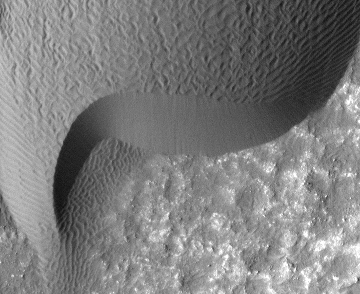
SHOCK OVERPRESSURE. The distribution of dust avalanches around this impact cluster follows a two-lobed pattern best explained by the interaction of blast waves in the air. General view at left, the crater cluster top right, and dust avalanches bottom right. (Image: NASA/JPL-Caltech/University of Arizona)

The crater cluster lies 825 kilometers (510 miles) south of Olympus Mons, on part of the wind-eroded Medusae Fossae formation. The largest crater in the cluster is about 22 meters (72 feet) in diameter. Wind-carved ridges called yardangs dominate the area, and it is thickly coated with dust deposits. The crater cluster was captured in image PSP_002764_1800 taken by the HiRISE camera on NASA’s Mars Reconnaissance Orbiter.

By the time the scientists were finished, they had nearly 65,000 dust avalanches counted and classified on yardang slopes within 6 km (4 mi) of the impact cluster. The team expected to find a pattern of avalanches that was symmetrical around the impact cluster, which is what would produced by seismic shock waves traveling radially through the ground after the impact.

Instead, they mapped a dust avalanche pattern that showed two wings shaped like scimitars, one extending south and another, fainter one to the northwest.

They write, “Models of airblasts generated by an obliquely traveling supersonic meteorite in the Martian atmosphere reproduce the “parabolic” scimitar-features we observe.” The meteorite was probably traveling in general west to east direction at an oblique angle.

In the light and dark features of each scimitar wing, the scientists see evidence for airblast waves from the incoming meteorite colliding and interfering with the outflowing blastwave after it struck the ground. Because the impact site shows a tightly spaced cluster of small craters, it is clear the incoming meteorite broke apart before striking the ground. Each piece likely contributed an aerial shockwave to blend and mix with the others.

“Impact-generated airblasts causing tens of thousands of avalanches or slope streaks may constitute a locally important and previously unrecognized process for slope degradation on Mars,” the team concludes.

Posted in Reports | Tagged , , , , , , , , , | Comments Off

Opportunity discovers water-precipitated gypsum at Cape York

The Mars Exploration Rover Opportunity has found thumb-wide veins of gypsum in a rock layer at Cape York, the Endeavour Cater rim segment where it will spend the coming Martian winter. The discovery was announced at the fall meeting of the American Geophysical Union.

IN THE VEIN. A light-colored vein of what is likely water-precipitated gypsum sticks up a new millimeters above the soil at Homestake, an exploration site near where Opportunity will spend the Martian winter. (NASA/JPL-Caltech/Cornell image)

The gypsum is, in the words of MER principal scientist Steven Squyres (Cornell University), “the single most bulletproof observation for water that Opportunity has seen.”

The rover first spotted the light-colored veins in an area of bedrock as it approached Cape York in August 2011. However, project scientists were eager to examine the rocks of the Endeavour rim, and simply noted that the veins looked interesting and drove onward.

The rim rocks proved unlike any seen before by Opportunity in the nearly eight years since it landed, in January 2004.

“When we got to Cape York,” says Squyres, “it was like starting a new mission all over.” The Cape York rim rocks include several — dubbed Tisdale, Chester Lake, and Transvaal — that bear clear hallmarks of the ancient impact that made Endeavour. These include pieces of broken rock embedded in a matrix of once-molten impact melt.

The impact-altered rocks collectively will be called the Shoemaker Formation when formally described in the geological literature. Earlier, the project named the high ground running down the spine of Cape York “Shoemaker Ridge,” to honor Eugene Shoemaker who was one of the founding fathers of planetary science.

After studying the impact-related rocks, scientists drove Opportunity northward along a bench-like layer to a site dubbed Homestake. Here was another light-colored vein, about as wide a thumb and standing a few millimeters above the soil. The scientists drove the rover’s wheel over the vein several timnes, then deployed the APXS spectrometer on it. This said the vein was full of calcium and sulfur, which pointed to gypsum, the commonest sulfate mineral that precipitates from water.

Big impacts, such as that which created the 22-kilometer (14-mile) wide Endeavour, trigger hydrothermal activity in the target rock. Existing groundwater below the crater creeps upward into fractures in the crater floor and rim. The lingering heat from the impact warms the groundwater and helps it extract minerals from the surrounding rock. Carried in solution through the fractures, the minerals then precipitate when the water cools.

“We can’t say for sure it’s gypsum because the vein is too small to fill the instrument’s field of view,” Squyres says. “But we subjected it to blunt-force trauma in the name of science.”

The team plans to do further tests on it when Martian spring arrives. That is also when the team will drive Opportunity south on the eastern side of Cape York to explore the Shoemaker formation more fully.

Posted in Reports | Tagged , , , , , , , , | Comments Off

High ground on Cape York rim segment named Shoemaker Ridge

Scientists with the Mars Exploration Rover Opportunity have given the name of Shoemaker Ridge to the highest “spine” of the Cape York segment of Endeavour Crater’s rim. The rover arrived at Cape York in early August and has been exploring this 3-meter (10 foot) high remnant of the crater’s original rim.

HEIGHT OF LAND. Cape York is a heavily eroded segment of the rim of Endeavour Crater, a 22-kilometer (14 mile) wide impact crater. The high spine running down the length of Cape York has been named Shoemaker Ridge. Opportunity is currently near the north end of Cape York, finding a location to spend the coming Martian winter. (NASA/JPL/Cornell/University of Arizona image)

“We named the ridge to honor Eugene Shoemaker, in many ways the founder of our science,” says Ray Arvidson (Washington University). Arvidson, deputy principal investigator for the MER project, spoke at the fall meeting of the American Geophysical Union.

“Our plan,” he continues, “is to use the Shoemaker Ridge’s name in the formal identification of the impact breccia rock which Opportunity is exploring. It will be called the Shoemaker Formation.” Rules for naming geological formations forbid naming them for a person directly, and require a reference to a specific geographical feature where the rock unit is exposed.

Opportunity is settling down at the north end of Cape York for the coming Martian winter on a slope that inclines northward, to maximize solar power generation.

When Martian spring arrives, if the rover remains healthy, project scientists plan to turn it south and explore along the east-facing slope of Cape York, where they believe the impact breccia is best exposed.

Posted in Reports | Tagged , , , , , , | Comments Off

Shifting sands

Sand — in wind-blown ripples, drifts, and dunes — lies all over Mars. But it poses a puzzle because the current atmosphere is too thin (less than 1% of Earth’s) to move that much sand around. So researchers in the past have proposed that most of the dunes are fossils, put in place during some previous era with a denser atmosphere.

MOVING SANDS IN HERSCHEL CRATER. A rippled dune front in Herschel Crater moved an average of about two meters (about two yards) between March 3, 2007 and December 1, 2010. The ripple pattern on the dune surface changed completely during the interval. Image credit: NASA/JPL-Caltech/Univ. of Ariz./JHUAPL.

Not so fast, says a group of scientists led by Nathan Bridges (Johns Hopkins University Applied Physics Laboratory). Writing in the journal Geology, they examined sand dunes and ripples in dozens of locations with high-resolution images from the HiRISE camera on Mars Reconnaissance Orbiter.

The study involved pairs of HiRISE images, with one to two Mars years (one Mars year lasts 679 Earth days) elapsing between them. Migration of sand ripples was detected in Nili Patera, Kaiser Crater, Herschel Crater (see this animated GIF), Matara Crater, Proctor Crater, and Meridiani Planum. (Future studies will continue the observational baseline.)

“We found that many sand ripples and dunes across Mars show movement of as much as a few meters per year,” the team writes. “This demonstrates that Martian sand can migrate under current conditions.”

Some changes they observed contradict previous interpretations. For example, in earlier images made with the MOC camera on Mars Global Surveyor, the dunes in Herschel Crater appeared to have a grooved texture. Scientists interpreted this as cemented sand that was undergoing abrasion. However, in the HiRISE images, the texture is seen as complex sets of intersecting ripples that change over time.

The key to the process, the researchers explain, is that most sand movement is probably driven by wind gusts. These are not figured into existing global wind circulation models which have generally coarse resolution.

“A past climate with a thicker atmosphere is required only to move large ripples that contain coarse grains,” they say.

Posted in Reports | Tagged , , , , | Comments Off

Valley networks were eroded quckly

Networks of valleys cross much of the ancient surface of Mars, and along with deltas and other features these all show that the environment once warm and wet enough to sustain liquid water at the surface. But when? And for how long?

WHERE WATER FLOWED. Valley networks cut across many parts of Mars, testifying to an early period when the environment was warmer and wetter than today's. But it didn't last long: 100,000 to perhaps 10 million years, says a new research report. (Image is Figure 1 from the paper.)

Concerning the When, the number of craters found in Martian valley networks suggest these formed around the late Noachian to early Hesperian eras, roughly 3.5 to 3.8 billion years ago.

As to How long, a group of scientists led by Monica Hoke (University of Colorado) studied seven large Martian valley networks to calculate how long it took to erode them. They then used this figure as a way to set bounds on how long that warm-and-wet period lasted.

The result, published in Earth and Planetary Science Letters (September 29, 2011) shows the period was brief in geologic terms, something like 100,000 to 10 million years.

Despite uncertainties in how fast the erosion would occur, the team says, “The amount of time required to form these large valley networks does not extend valley formation earlier than the Late Noachian.”  The results, they say, also fit with ideas that valley-making was constrained to the Noachian–Hesperian transition in geologic time.

Posted in Reports | Tagged , , , , | Comments Off

When Apollinaris Patera went boom

Stretching more than 5,000 kilometers (3,000 miles) between the two volcanic centers of Tharsis and Elysium is a geological enigma, the Medusae Fossae formation. The formation, which lies in several separate patches, appears to be made of easily eroded materials, but its origins remain unknown.

LOCATION, LOCATION, LOCATION. While Apollinaris Patera is a relatively small volcano, it's placed just right to be the source for the Medusae Fossae formation (outlined in black). This enigmatic deposit appears to be made of easily eroded material, such as the fine ash produced in explosive eruptions. (Image is Figure 1 from the paper.)

A recent study led by Laura Kerber (Brown University) and published in Icarus examines the question of whether the formation was created by explosive eruptions from Apollinaris Patera, a volcano that lies next to one part of the formation. Such eruptions are called pyroclastic and produce large volumes of ash and other fine particles that can easily be carried on the wind.

A volcanic origin for the Medusae Fossae formation has been proposed for almost 30 years, but geologists have looked to bigger volcanos than Apollinaris for a source. Apollinaris is 5 to 6 kilometers high and nearly 200 km across its base. That’s big, but nothing like the giants found in Tharsis and Elysium. However, scientists think that Apollinaris’ eruption style favored explosive events that produced windblown ash rather than large volumes of runny lava, as produced in Tharsis and elsewhere.

“The height of Apollinaris and its position in the center of the deposit would make it possible for the volcano to disperse voluminous amounts of ash over the widespread areas covered by the Medusae Fossae formation,” notes the team.

They add that it’s likely the volcanic activity depositing the formation came not in a single episode, but in “many short eruptions (days to months) taking place over random times of the year over hundreds of millions of years.”

A recent rethinking of the age of the formation also favors Apollinaris as a source. Initially, the formation was believed to be younger than the last activity from Apollinaris, and therefore the volcano couldn’t have been the formation’s source.  But because the soft materials in the formation erode easily, it presents a deceptively young appearance and more careful dating places it and the volcano as contemporaries.

Finally, while containing many uncertainties, computer models of the Martian climate support the idea that once lifted to altitudes of 15 to 20 kilometers in the atmosphere, pyroclastic debris from Apollinaris Patera could be carried by the wind for the distances required.

The team notes, “Depending on what time of the year a particular eruption took place, ash from Apollinaris could accumulate in different parts of the deposit.”

Posted in Reports | Tagged , , , , | Comments Off

Martian surface: icy, cold, and dry for 4 billion years

Maybe the warm and wet environment on early Mars that scientists have long proposed wasn’t at the surface, but rather buried in the crust. That’s one of the conclusions of a new review that looks at Martian clay minerals and the environments where they likely formed.

MOSTLY COLD AND DRY UP TOP, but warmer below? Mapping outcrops and exposures of clay minerals reveals they occur across nearly all of Mars, but their character differs. Crustal clays formed underground, while sedimentary clays were made at the surface, which has been warm and wet only rarely. (Image is Figure 1 from the paper.)

Scientists have now logged the detailed mineralogy at more than 350 places on Mars where clay minerals appear. By far the majority of these date from the earliest known period in Martian history, the Noachian, about 4 billion years ago to around 3.7 billion years ago. More important, the chemical nature of the clays suggest that they formed when warm groundwater came in contact with subsurface crustal rocks for long periods.

The review, by a team of scientists with lead author Bethany Ehlmann  (Caltech/Jet Propulsion Laboratory), was published in Nature November 3, 2011.

The team writes, “Evidence from the Martian rock record indicates that most clay minerals — specifically, those comprising Fe,Mg clay mineral units deep in the crust — formed in the subsurface in closed systems at temperatures ranging from ambient to low-grade hydrothermal (less than 400°C).”

The warmth, they note, could have come from any of several sources: volcanism, residual heat after large meteorite impacts, and a geothermal heat flow stronger than today’s.

Not all clays are likely to have formed underground, they say. Among the many clay deposits mapped across Mars are relatively rare ones rich in sulfates and chlorides. These appear to have been produced by weathering at the Martian surface, which washed the minerals into hollows, pockets, and craters. Also, a few locations with aluminum-rich clays at the top of the layers suggest that localized sources of water near the surface leached elements from basalts rich in iron and magnesium.

The new view of subsurface clay formation might ease a growing problem, namely that it has been getting difficult for scientists to argue for a Mars that was warm and wet at the surface for more than brief periods. The reason is that most of the Martian crust is not chemically leached, and evidence for a thick early atmosphere that would have sustained a warm climate has been hard to come by.

As the team writes, “Cold, arid conditions with only transient surface water may have characterized Mars’s surface for over 4 billion years, since the early-Noachian period, and the longest-duration aqueous, potentially habitable environments may have been in the subsurface.”

Posted in Reports | Tagged , , | Comments Off

Elysium’s eruptive history

STILL ACTIVE? Volcanic eruptions have had a varied history in Elysium, as seen in this graph with ages noted in millions of years. Note the large bump of activity about 2.2 billion years ago, and the continuing lower level of activity down toward today. (Image is Figure 8b from the paper.)

Elysium is Mars’ second-largest volcanic province after Tharsis. A new study by Thomas Platz and Gregory Michael (Freie Universität Berlin) published in Earth and Planetary Science Letters (October 30, 2011) counts craters on its volcanos and the main lava flows to sketch a history of volcanic activity in the province.

The researchers find that Elysium shows a few areas that are around 3.9 billion years old, which provides an oldest-known date for activity in the region. “This age is derived from buried craters underlying a shallow flow unit,” say the scientists. Volcanic activity could have occurred before then, but no traces of older surfaces remain.

The flows and crater counts show that Elysium underwent a major peak of volcanic activity centered about 2.2 billion years ago. Thereafter, volcanism dwindled sharply but continued until the recent past; there have been only 12 lava flows in the last 500 million years. The scientists estimate the youngest Elysium lava flows are about 60 million years old, and they note, “Extrapolating the eruption record, it appears likely that this region of Mars is still volcanically active today.”

Posted in Reports | Tagged , , | Comments Off

Dune activity in Arabia and Meridiani

Mars continues to show itself active, at least as far as dunes are concerned. A new study published in Geophysical Research Letters (October 22, 2011) by a group of scientists led by Simone Silvestro (SETI Institute) reports on dune movements in Arabia and Meridiani recorded between 2007 and 2010. The team used images from the Viking mission and THEMIS daytime infrared observations for a base map, and identified changes using the HiRISE camera.

SANDS OF ARABY. A Viking color mosaic shows the areas of dune motion studies in Arabia and northern Meridiani. At the Arabia 4 site (lower right), the team detected two lee dunes merging, a first for Mars. (Image is Figure 1a from the paper.)

They found six sites with clear signs of modifications due to wind over the course of a Martian year. One of their study sites, Arabia 4 (see image at right), offered the first known Martian example of lee dunes merging. In their Meridiani study areas, only one showed signs of change. Work by others has already located moving dunes in Endeavour Crater, currently the exploration target of the Mars rover Opportunity (See “Will Opportunity find dunes on the move?“)

The team concludes that, “Dune advancement may be common throughout the Martian tropics.”

Posted in Reports | Tagged , , , | Comments Off

Early Martian surface radiation not too strong for life

During the Noachian period (about 4.5 to 3.5 billion years ago), the Martian atmosphere was substantially thicker than it is currently, and the planet had a magnetosphere with a surface field strength about as strong as Earth’s today. Both factors would have dimished the amount of cosmic and solar radiation reaching the surface, and thus aided the possible emergence of life on Mars.

A group of researchers at Christian Albrechts University Kiel and the German Aerospace Center have calculated the surface radiation environment assuming densities 25, 50, and 100 times greater than today’s atmosphere. Writing in the Journal of Geophysical Research (October 20, 2011), they found that radiation rates at the surface (for neutrons, protons, muons, antimuons, and alpha particles) were comparable to present-day Earth. They note, “The Noachian radiation environment should have looked different from present-day Martian conditions. In particular, it should have been less hazardous for an emergence of life.”

Posted in Reports | Tagged , , , , | Comments Off